Before-and-after satellite images show flood devastation in B.C.'s Sumas Prairie
Historic rainfall flooded farm fields, forced evacuations and killed livestock
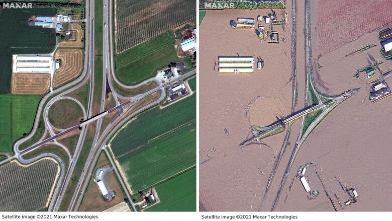
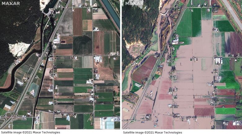
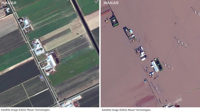
Dramaticsatellite images show the extent of flood damage in B.C.'s Sumas Prairiefollowing last weekend's historic rainfall.
The low-lying rural area, east of Abbotsford's town centre, is mostly farmland and was created by the draining of Sumas Lake in the 1920s.
Last week the area suffered extensive flooding as water gushed in from the Nooksack River from neighbouring Washington state, forcing evacuations and killing livestock.
In images provided by Maxar Technologies, farmland in the region is shown on June 27 this year and again on Friday.
Many homes, barns and roads were left submerged under murky brown water following the storm, as seen in the composites above and below.
A pilot who has been helping to bring supplies to affected communities in the regiontold CBC News on Monday that the Hell's Gate Airtram attraction in the Fraser Canyonarea was"gone" following the storm,but the company saidon Tuesdaythis is not the case.
Maintenance staff were on site at noon Tuesday and confirmed the airtram is intact, the management team said. They also noted the staff took a picture of it, which was posted to the company's Twitter page.
We would like to address the recent rumours that Hells Gate Airtram is completely gone due to the flood. According to the our maintenance staff on site, it is still intact. pic.twitter.com/bJPT2BNJzr
—@hellsgatetramWhen reached on Tuesday, the pilot, Shaun Heaps, saidhe was relieved by the news, adding that when he flew over Hell's Gate he couldn't see it.
Recovery efforts continue
More troops arrived in the province over the weekend to help farmers in the Sumas Prairie area save livestock and lend a hand in sandbagging efforts.
On Saturday, the mayor of Abbotsford told a news conference that round-the-clock work has improved the flooding situation in the region.
Flood gates at a pump station that has struggled to keep up with the influx of water in Sumas Prairie were able to partially reopen, allowing excess waterfrom the Sumas River to flow into the Fraser River, saidMayor Henry Braun.
"There's a dramatic change already in certain parts of the prairie," said Braun. "I can visually see a lot of green fields."
But withmore rain expected in the coming week,Braun has extended a local state of emergency untilNov. 29.
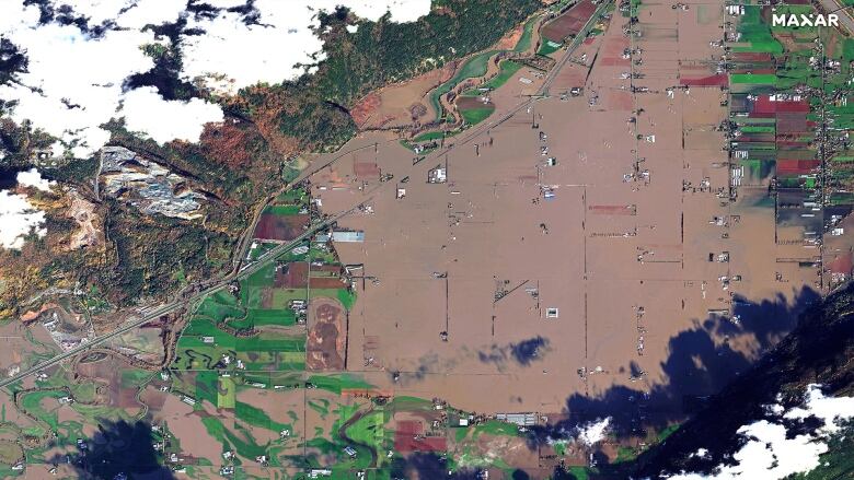
See more of the flood damage in the region (all images taken on Friday):


Corrections
- A previous version of this story quoted a pilot saying the Hell's Gate Airtram "is gone" due to the floods. The company has since told CBC News that the airtram is still intact.Nov 23, 2021 4:36 PM PT
With files from Chad Pawson and The Canadian Press


_(720p).jpg)


 OFFICIAL HD MUSIC VIDEO.jpg)
.jpg)


