Hundreds of properties evacuated in B.C.'s Interior as winds spur growth in wildfires
Winds up to 60 km/h making it difficult to fight area's largest blaze, officials say
Windy conditions in British Columbia's Interior have prompted authorities to order hundreds of properties evacuated and close several highways throughout the Okanagan and surrounding areas Sunday evening as wildfires grew in size.
The City of Armstrong, about 75 kilometres north of Kelowna,issued an evacuation alert for the entire communityof roughly 5,000 as the White Rock Lake fire burned about 20 kilometres outside of town.
Some of the largest and most dangerous fires are burning in the southern Interior in the Kamloops fire centre where most of the new evacuation orders have been issued.
The Okanagan Indian Band near Vernonissued an evacuation order for more than 80 propertiesSunday afternoon. Around the same time, the nearby Spallumcheen Township upgraded an evacuation alert for dozens of properties to an evacuation order.
And onSunday evening, the City of Kamloops issued an evacuation alert for 734 proprietiesin several neighbourhoods as the Tremont Creek wildfiregrew. The entire town of Merritt, four hours northeast of Vancouver, was also put on evacuation alert due to the Lytton Creek wildfire.
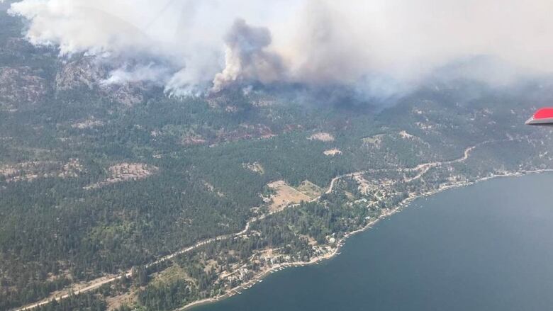
Meantime, the White Rock Lake fire iscurrently burning out of control and estimated at about 622 square kilometres.
WATCH | B.C. residents assess wildfire damage as winds pick up:

The strong winds and heavy smoke grounded air support crews working on the northeast flank of the fire in the Naswhito Creek area.
Fire information officer Erika Berg says wind gusts reaching up to 60 kilometres per hour saw flames jump containment lines in multiple areas.
TheThompson-Nicola Regional District said it would issue an evacuation order for all areas of Cherry Creek south of the Trans Canada Highway, near Kamloops, as well as properties on the south side of the highway in the Tobiano area.
It also issued an evacuation order for 656 properties in the Lower Nicola area north of Merritt due to the Lytton Creek wildfire burning nearby.
Meanwhile, the Central Okanagan Emergency Centre said a new wildfire in West Kelownathe MountLaw wildfire hasstarted near Highway 97C. It later declared astate of emergency for the city due to the fast-moving fire.
It also issued an evacuation order for dozens of propertiesin the immediate area of the fire.
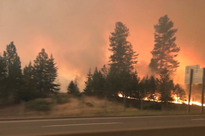
Early Sunday evening, Highway 5 between Hope and Merritt, just a couple hours drive east of Vancouver, was closedin both directions due to wildfire activity in the area.
The province issued a release Sunday evening warning travellers that highways in B.C.'s Interior could be closed, with limited notice,due to wildfire.
Woah! That was a terrifying experience driving the #coquihalla, just north of Britton Creek. Im shaking! We made it through just as they were stopping southbound traffic @DriveBC #bcwildfires #Kamloops 7pm August 15, 2021 pic.twitter.com/1hOepHLSmE
—@MarinaLeClairPotential for growth
Earlier in the day,Berg called the gusty winds a challenge for firefighters and residents, saying they were fanning the flames of blazes in the southern and Interior regions.
Berg saidmany of the bigger fires of note grew overnight, including the Tremont Creek fire, which led to the evacuation of the district of Logan Lake and the nearbyHighland Valley Copper Mine.
"What we're anticipating for todayis for it to be windy, more windy than yesterday, which will likely result in increased fire activity and potential for growth," Berg said.
"We did see the winds as forecasted and they did challenge our containment."

Logan Lake Fire and Rescue ChiefDoug WilsonsaysMonday that no structures havebeen lost to the wildfires, thanks to the rooftop sprinklers installed at homes in town since 2013.
He also says his crew slept for only four to five hours before getting back to work, and asks Logan Lake residents not to stay behind in fire zones.
"It's a risky move you put your family at harm, you put our people at harm because we have to stop firefighting to come rescue you," he told Doug Herbert, the guest host of CBC's Daybreak Kamloops.
Berg saidthere are about 270 active wildfires burning in the province, with a total of just under 7,000 square kilometres of land scorched.
Less than 10 square kilometres of land had burned by this time last year, she said, describing 2020as a particularly quiet year for wildfires.
Berg said the current burned area is about seven times greaterthan the 10-year average, which isabout1,770 square kilometres.
The two most active years for the service were 2017, whenabout 12,000 square kilometres of land charred, and 2018, when about13,500square kilometres burned.
Anyone placed under an evacuation order should leave the area immediately.
Evacuation centres have been set up throughout the province to assist anyone evacuating from a community under threat from a wildfire. To find the centre closest to you, visit theEmergency Management B.C. website.
Evacuees are encouraged to register withEmergency Support Servicesonline, whether or not they access services at an evacuation centre.
Corrections
- An earlier version of this story incorrectly stated the amount of land burned by wildfires in B.C. in 2017 and 2018.Aug 16, 2021 6:35 AM PT
With files from Akshay Kulkarni, the Canadian Press and Daybreak Kamloops


_(720p).jpg)


 OFFICIAL HD MUSIC VIDEO.jpg)
.jpg)


