Campfire bans now cover most of B.C. as heat records fall across the province
Daily temperature records have been set from Fort Nelson to Vancouver Island

More fire bans are coming into place as daily heat records are brokenacross B.C. and scientist continue to warn about the dangers of human-caused climate change.
According to data from Environment and Climate Change Canada (ECCC) newrecord daily temperatures were set for July 5 in Burns Lake (28.7 C), Comox(30.3 C), Fort Nelson (31.7 C), and Sechelt(31.5 C).
In Fort St. John, the temperature reached 27.2 C, tying a record set in 1961.
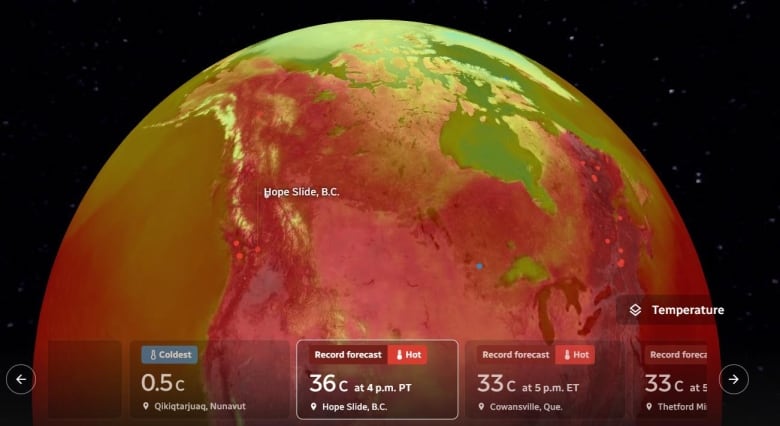
CBC's Climate Dashboard, which uses ECCC data, shows that record high temperatures are expected in five other places in B.C. on July 6. Record temperatures are forecastin several areas near Victoria, which is expected to be 28 C this afternoon.Qualicum Beachis forecast to hit 30 C. And temperatures at Hope Slide in the southern Interiorcould reach36 C by 4 p.m. PT.
WATCH | Drought conditions on Vancouver Island:

In part because of this persistent high heat and low precipitation, more campfire bans are on the way in British Columbia.
The B.C. Wildfire Service says the Cassiar and Bulkley fire zones within the Northwest Fire Centre will prohibit campfires starting at noon, adding to the ban imposed in that centre's Nadina fire zone last month.
Campfires will also be prohibited across the entire Cariboo Fire Centre at noon on Friday.
That leaves the Southeast Fire Centre and one zone within the Northwest Fire Centre as the only B.C. areas where campfires will still be permitted.
Additionally, water restrictions are in place in several regions including parts of Vancouver Island and the northeast because of high drought levels.
Dangerous heat could cost B.C. lives
The B.C. heat records come on the heels of what some scientists say was the hottest day ever recorded on earth.
According to scientists at the University of Maine's Climate Reanalyzer project, which uses satellite data and computer simulations, the entire planet sweltered on July 4 and 5, marking the two unofficial hottest days in human record-keeping history an average of 17.18 C (62.9 F). Earth's average temperature remained at that level early Wednesday.
Those records come as a new report commissioned and funded by the B.C. government found that extreme heat couldkill 1,370 people and send 6,000 to hospital each year inBritish Columbia by 2030 if the province doesn't adapt its essential infrastructure.
The report, titled The Case for Adapting to Extreme Heat: Costs of the 2021 B.C. Heat Wave, is the first cost analysis of the heat dome in late June 2021, during which temperaturessoared to record levels.
It saysthedisaster cost nearly $6 billion in human life lost, and $12 million in hospital care and expects that pattern to repeat if changes aren't made.
"All regions of Canada will need to adapt to these changes or risk repeating the deadly and costly outcomes of B.C.'s 2021 heat wave," reads the report.
More than 100 active wildfires
As campfire bans come into effect, theB.C. Wildfire Servicereports more than 100 active fires in B.C., most of them concentrated in the northeast, including a suspected lightning-caused fire south of Fort St. James that was spotted Wednesday and has the potential to cut off the only road to the community.
"Multiple initial attack crews are currently responding to assess the fire and determine additional resource needs,'' the wildfire service said in its description of the blaze that had charred half-a-square-kilometre of grass, brush and heavy timber on the west side of Highway 27 within hours of flaring up.
#BCWildfire Service is responding to the Tsah Creek wildfire (G41149), located ~24 km S of #FortStJames. This lightning-caused fire was detected this afternoon (July 5), is currently estimated at 30 hectares in size and is classified as out of control. pic.twitter.com/eDyd1XgOSj
—@BCGovFireInfoA heavy equipment team, air tankers and helicopters are also being deployed to the area about two hours by road northwest of Prince George, the wildfire service said.
Crews have also started arriving from Mexico to help with efforts tocontain the fires.
With files from the Canadian Press and the Associated Press


_(720p).jpg)


 OFFICIAL HD MUSIC VIDEO.jpg)
.jpg)


