Snowstorm creates travel chaos across B.C.'s South Coast
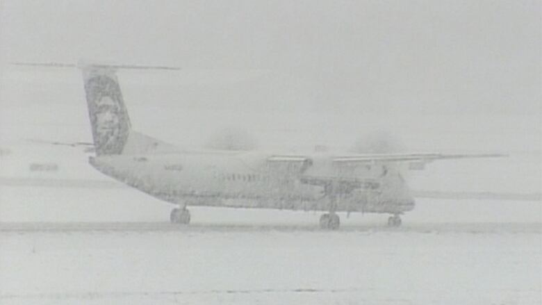
Victoria International Airport cancelled several flights after running out of de-icing fluid

A dump of wet snow across much of B.C.'s South Coast is causing headaches for travellers, after flights were delayed at major airports in Vancouver and Victoria.
Several flights at Victoria International Airport were cancelled, and many delayed, after the airport ran out of de-icing fluid. As the snow turned to rain, many of the cancelled flights resumed.
Airport spokesmanTerry Stewart said it's the first time the de-icing fluid supply has run out on Saturday, the airport had more than 12,000 litres of glycol, but none was left this morning. In the meantime, the airport is arranging to bring inde-icing fluid from other airports.
"We're looking at a secondary supply from Vancouver International trying to get that over here as quickly as possible, and the logistics of that are not easy," he said.
A spokespersonfor Vancouver International Airport said snow removal operations were in full effect Monday morning and the airport was fully staffed and equipped to handle the winter weather, but dozens of flights were delayed.
Some flight cancellations and delays are reportedly due to poorconditions at other airports.
The airport authority said thatif temperatures stay cold, many more delays and cancellations could be expected.
Power outages, school closures
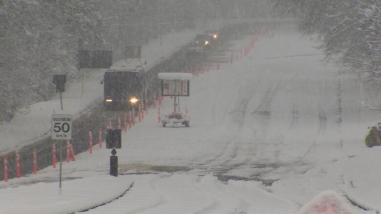
Snow continued to fall across much of the South Coast Monday, with accumulations varying greatly depending on location and elevation.
While some sea-level areas have seen almost no snow stick over the weekend, parts of Vancouver Island and the Fraser Valley have accumulated up to 30 centimetres.
Heavy snow overnight across parts ofVancouver Island forced anumber of school closures.
Poor weather conditions also contributed to a number of power outages.
BC Hydro spokeswoman Simi Heer said thousands of customers in Metro Vancouver and the Fraser Valley lost power Sunday night, including 4,300 in Surrey, 3,100 in White Rock, 4,100 in Maple Ridge, 12,000 in North Vancouver and 2,000 in Burnaby.
As of 11 a.m. PT Monday, around 1,800 customers were still without power in the Lower Mainland with the vast majority located in West Vancouver.
Lights were out across much of southern and eastern Vancouver Island as well, with as many as 18,000 BC Hydro customers affected by power outages Monday morning.
BC Hydro expects most lights to be back on before 4 p.m. PT on Monday, but warns there could be more power outages.
"Today, for the Lower Mainland and Vancouver Island, there is a risk of tree branches, weighed by heavy snow, coming down on power lines and causing more outages," Heersaid in a written statement.
Snowfall warnings in effect
Snowfall warnings are still in place for the east side of Vancouver Island, the Southern Gulf Islands, Greater Victoria, Metro Vancouver and the Fraser Valley.
At 8:30 a.m. PT Monday,Environment Canada was predicting anywhere from five to 10 more centimetres of snow for the mainland, while eastern Vancouver Island is likely to get between 10 and 15 more centimetres of snow.
The continuing snowdump is the result of two weather systems, thefirst of which slid in from Haida Gwaii Saturday morningand then hung around until Sunday.
The second system, which moved in late Sunday night, coupled with cold easterlywinds blowing across the Fraser Valley to make even more snow today.
The CBC's Johanna Wagstaffe said the paired snowstorms are a unique situation that none of the weather models saw coming Friday.
"This was a wild pair ofstormsto forecast," she said."I think this is one meteorologists will be talking about for some time."
The snow days will come to an end soon, however, asmildPacific air is expected toturn thesnowfall to rainfall in most areas starting late Monday afternoon.
Gallery:Snow days descend on South Coast
Unofficial snowfall totals forMonday, Feb. 24, at 2p.m. PT
- Burnaby (SFU): 20 cm
- Campbell River: 33cm
- New Westminster 25cm
- PortAlberni: 11cm
- Horseshoe Bay: 27cm
- Whatcom (Fraser Valley): 17cm
- Cloverdale: 15cm
- North Vancouver: 25-35cm
- East Vancouver Island: 20-40cm
- South Vancouver Island: 15-30cm
- Surrey: 15-20cm
Official snowfall totals for past 36 hours:
- Victoria International Airport (YYJ): 15 cm
- Comox: 16 cm
- Nanaimo: 34 cm
- Vancouver International Airport (YVR): 4 cm
- Downtown Vancouver: 0 cm
Source:Environment Canada weather summaries
With files from the CBC's Johanna Wagstaffe, Stephen Smart and Jesara Sinclair


_(720p).jpg)


 OFFICIAL HD MUSIC VIDEO.jpg)
.jpg)


