Earthquakes shake Lower Mainland, northern B.C.
Earthquakes Canada reports a mild earthquake in the Lower Mainland hours before a minor quake in northern B.C.

A 3.5magnitude earthquake near Tsawwassen, B.C., shook the Lower Mainland Friday morning, hours before a 4.2 magnitude earthquake in northern B.C. rattled Fort St. John, according to Earthquakes Canada.
While residents reportfeeling the first quake, Earthquakes Canada says there are no reports of damage from either of thequakes, and no damage is expected for earthquakes of their magnitude.
"[The earthquakes]would feel like a truck hit a curb outside of your house. Your whole house might kind of shake and there's a loud bang sound," saidBrindley Smith, a seismic analyst with Natural Resources Canada.
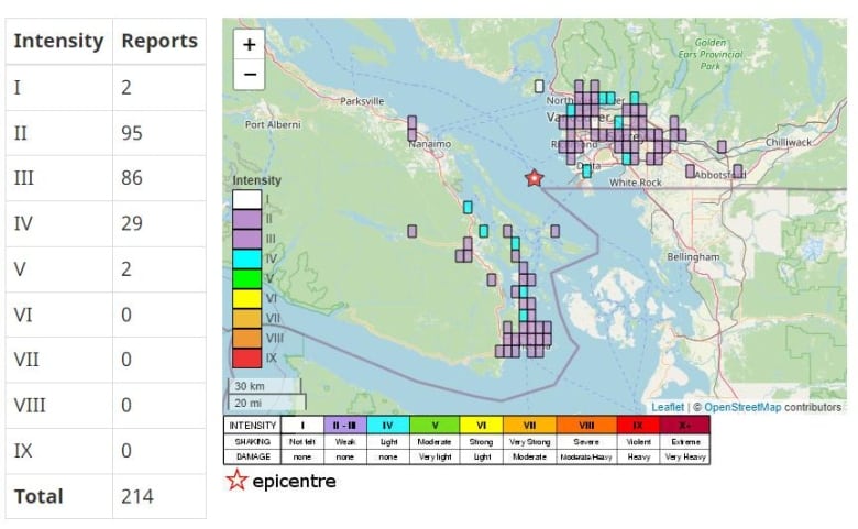
Earthquakes Canada says the first earthquake happened just after 2 a.m. PT in the Strait of Georgia, about 29 kilometres southwest of Vancouver and 17 kilometres west of Tsawwassen.
Smith said initially, it was detected as a 3.8 magnitude earthquake, before better modelling helped the agency determine the earthquake had a lower magnitude.
Residents report feeling the earthquake on Vancouver Island, between Nanaimo and Victoria. People across the Lower Mainland also report feeling the quake.
An interactive map from Earthquakes Canada shows where residents report feeling the earthquake.
Others took to social media to talk about the quake including VancouverCoun. Peter Meiszner.
Anyone else woken up by an apparent earthquake in Vancouver just now?
—@PeterMeisznerThe second earthquake happened at about 5 a.m. MT, about 63 kilometres west of Fort St. John.

Another interactive map from the agency shows residents felt the quake lightly near that town.
The occurrence of two earthquakes in a row is a coincidence, according to Smith.
"It's just pure chance, really," hesaid. "It's just the way seismicity tends to tends to work. It's very random."
Smith said the earthquakes could triggersmaller earthquakes, but not anything of equal or greater magnitude.
"We would not associate this with 'TheBig One'," he said. "People can rest assured there thatthese are not going to be causing a huge shift to happen."

Are we ready for "The Big One"?
CBC Vancouver's podcast seriesFault Linesexplores the potentially devastating effects of a massive magnitude earthquake predicted to hit the West Coast of North America.Hosted by CBC senior meteorologist and seismology expertJohanna Wagstaffe, you can listen to Fault Lines now atApple PodcastsandCBC Listen.


_(720p).jpg)


 OFFICIAL HD MUSIC VIDEO.jpg)
.jpg)


