University campuses close as winter storm approaches South Coast
Simon Fraser University, Camosun College cancel classes as system rolls in
Winter isn't done with the Lower Mainland just yet.
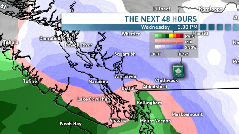
Environment Canada has issued a winter storm warning for the entire B.C. South Coast, from Victoria to the Fraser Canyon, with high winds, snow and freezing rain a possibility over an 18-hour period from Wednesday afternoon to Thursday.
In anticipation of the weather, several universities announced they'll be closed Wednesday afternoon.
- SimonFraserUniversity(Burnaby campus).
- British Columbia Institute of Technology (All campuses).
- Vancouver Community College evening classes (All campuses).
- Douglas College (all campuses).
- KwantlenPolytechnic University (All campuses).
- University of theFraserValley (All campuses).
- CamosunCollege.
- Vancouver Island University.
- University of Victoria.
"This is the finale," said CBC meteorologistJohanna Wagstaffe, warning that it willbe the most unpredictable of the weather systems to hit this season.
- PHOTOS: Huge snow dump at Harrison Hot Springs in pictures
- Here we go again: Metro Vancouver prepares for another wintry week
- Skiers rejoice after 'snorkel-deep' snow buries resorts in B.C., Alberta
"Because's there so much uncertainty with the timing and the exact changeover, it's one of those events where some people will say this was no big deal, and other will say this is the worst hit yet, because of how changing the conditions will be."
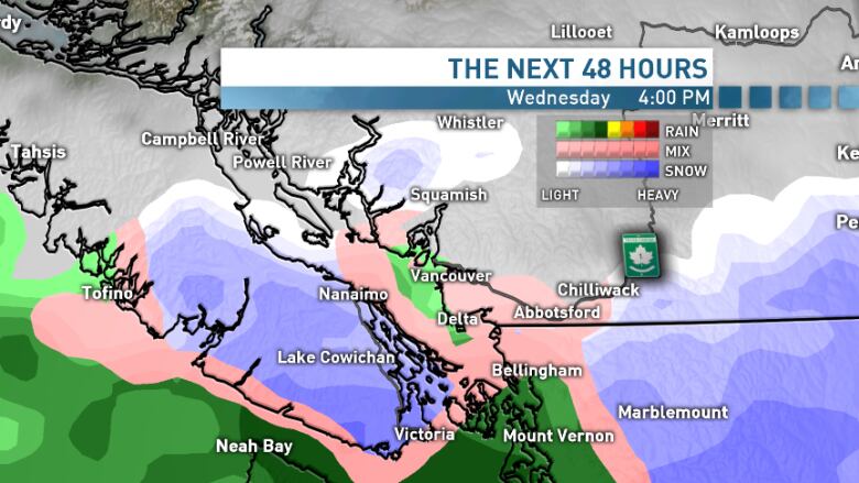
Here's how the stormexpected to play out.
Will arrive Wednesday afternoon
Wagstaffe says the storm will be the result of an intense, more traditional Pacific warm front arriving in the region on Wednesday afternoonbefore the cold front departs.
"We had this low-pressure system move in on Friday, that's been swinging through bands of precipitation, all falling as snow because of how cold the air is. This one should finally bring the warm air," she said.
The precipitation will begin falling as snow, with total amounts ranging from five to 10 centimetres at lower elevations and on Vancouver Island, and 15 to 20 centimetres further inland.
However, that will switch over to rain late Wednesday evening and overnight. At the same time, thewind is expected to pick up.
"This is a strong storm system. So on top of that, we'll have reduced visibility in the snow.We could be talking power outages, with the heavy wet snow becoming saturated," said Wagstaffe.
As a result, Environment Canada is urging extreme caution on the roads.
"Rapidly accumulating snow could make travel difficult over some locations. Surfaces such as highways, roads, walkways and parking lots may become icy and slippery. Localized flooding in low-lying areas is possible.
The system is expected to turn completely to rain by Thursday afternoon.


_(720p).jpg)


 OFFICIAL HD MUSIC VIDEO.jpg)
.jpg)


