What you need to know about B.C. wildfires for Aug. 16
Coquihalla Highway remains closed between Merritt and Hope after 2 fires merged
The latest on the wildfires:
- Thousands of properties in B.C. remain under evacuation orderMonday, including entirecities and communities in the Interior.
- Multiple buildings have been damaged by two separate fires in the Kelowna area.
- Some of the largest and most dangerous fires are burning nearKamloops.
- The Coquihalla Highway remains closed between Hope and Merritt.
- Drivers are being warned highways through the Interior couldshut downwith little to nonotice because of wildfires. Non-essential travelisbeing discouraged to keep evacuation routes clear for locals.
- For a full list of evacuation orders and alerts, visit Emergency Information B.C.
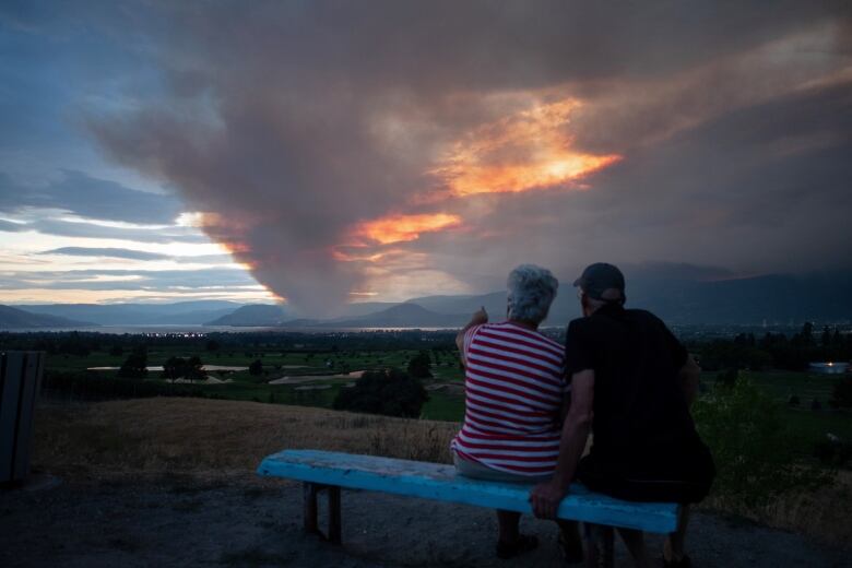
Thousands of properties remain under evacuation orderMonday after "exceptional" highwindsfuelled dozens of wildfires across B.C., sending flames barrelling toward entire communities.
Hundreds fled their homes under smoke-filled orange skies on Sunday as evacuation orders were issued, one after the other.Most of the newestevacuation orders are in the Kamloops area, where some of theof the largest and most dangerous fires in the province are burning.
There are at least a dozenwildfiresin the Kamloops Fire Centre district, including the Lytton, White Rock Lake, Tremont Creek and Sparks Lake fires.
Officials confirmed Monday the White Rock Lake fire has "significantly damaged" multiplebuildings in the quiet Killiney Beach area, north of Kelowna on the edgeof Okanagan Lake.
There has also been "limited damage" in West Kelowna, to the south,due to the separate Mount Law fire.
"Due to evolving conditions crews have not been able to complete a full assessment of structure damage.More information will be provided to property owners and the media as it becomes available," reads an email fromCentral Okanagan Emergency Operations.
To the northwest, more than 730 properties west of Kamloops remain on evacuation alertdue to the sudden growth of the Tremont Creekwildfire. Dozens more homes in the Cherry Creek area, south of Highway 1, are under evacuation order.
The Okanagan Indian Band near Vernon, B.C., is stillorderingresidents of about 80 properties to leave immediately if they have not yet done so.The North Okanagan was one of several parts of the Interior left in adark red twilight in the middle of the afternoon on Sunday, after thick smoke blocked out the sun.
Quick report from Armstrong where the sky is nothing short of surreal. pic.twitter.com/yYCTwOVubP
—@KatieNicholsonCare home residents and acute care patients in Armstrong, Lillooet, 100 Mile House, Merritt and West Kelowna have been relocated to other communities due to wildfire activity, according to Interior Health.
The health authority says families are being contacted withdetails of their loved one's temporary location, contact information and ongoing care.
In all, based on the Sunday count,the province said more than 6,600properties had been ordered evacuated. Another 16,000were on alert.
Fast-growing fire burning near West Kelowna
Another out-of-control wildfire,first spotted Sunday between Peachland and West Kelowna, just north of a major highway, forced nearly 500 evacuations in the Glenrosa neighbourhood of West Kelownawithin hours.
Evacuation orders issued overnightalso affect homes in Peachland.
Fire crews say "exceptional" winds quicklypushed the newly ignited Mount Law fire to eightsquare kilometres an area twice the size of Stanley Park.
"The fire quickly grew and became, quite frankly, a nightmare for our community," West Kelowna Fire Chief Jason Brolund said Monday in an interview.
"Like nothing I've ever seen before," he continued."The fire moved in almostevery direction and really acted like a snake. It surrounded an area of our community and then came down the hill towards the homes that were closest."
Carly Beatonhad to leaveWest KelownaforVernon, just a week after she was evacuated to West Kelownafrom her North Okanagan home in Fintry, due to the White Rock Lake wildfire.
"You could see the flames coming over the mountain and everybody was leaving," Beaton said Monday to Chris Walker, the host of CBC's Daybreak South, about what happened in West Kelowna'sGlenrosaneighbourhood over the weekend.
LISTEN| Carly Beaton had to move twice due to B.C. Interior wildfires:
Elsewhere in the Interior, entire communities remainon evacuation alert due to separate fires:theCity of Armstrong, the City of Merritt and the District ofBarriere. Combined, the communitiesare home to more than 12,000 people.
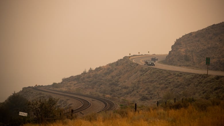
The Coquihalla Highway, a major link between the Interior and the Lower Mainland,remains closed between Hope and Merritt. The road had to beshut down after two fires on either side of the highway merged into one, according to the wildfire service.
Drivers who tookthe mountain route Sunday while it was still opendrove pastflames snapping at the edge of the pavement.
PLEASE RETWEET (photo from #Coquihalla last night)
Prepare for highway closures due to #BCWildfires - we may have to take action with limited notice.
Avoid non-essential travel to/within impacted areas to avoid traffic congestion on evacuation routes: https://t.co/QKhf3bl9Cl pic.twitter.com/ZUyhpE2AXe
—@TranBCOfficials are imploring tourists to stay away from Interior communities impacted by wildfires.
"If you're planning to travel to those areas, it's time to change your plans," Public Safety Minister Mike Farnworth said, suggesting travellers go elsewhere in the province.
There are nearly 270 active wildfires burning provincewide.Incessant heat and high winds have made the situation worse for weeks, but the B.C. Wildfire Service expects a break in the weather onMonday.
"We are looking at some reprieve. The heat wave is behind us. We're looking at precipitation, even, in the southern Interior, which has been a consistent area of concern for us this season," fire information officer Erika Berg told CBC Daybreak South in an interview Monday.
"We are anticipating some cooler temperatures, which will aid our fire suppression efforts, and [the] winds will not be as intense as they were last night," she said.
Air quality in the Kamloops and North Okanagan areas remainedpoor Monday. Cooler weather is expected to help with the haze from smoke.
A total of 1,513 wildfires haveburned a total of 7,667 square kilometres of land since April 1, accountingforanarea twice the size of Metro Vancouver.
"This is not a normal fire season by any measure," B.C. Minister of Forests, Lands, Natural Resource Operations Katrine Conroysaid during a press conference Monday.
The wildfire service said the total area burned is about seven times greater than the 10-year average.
Anyoneplacedunderanevacuationordershouldleavetheareaimmediately.
Evacuationcentreshavebeensetupthroughouttheprovincetoassistanyoneevacuatingfrom acommunityunderthreatfrom awildfire.
Tofindthecentreclosesttoyou,visittheEmergencyManagementB.C.website.
Evacuees are encouraged to register withEmergencySupport Servicesonline, whether or not they access services at anevacuationcentre.
READ MORE:
- Climate change is a top federal election issue for B.C. voters, poll finds.
- Property insurers are updating theirrisk modelling as Canada braces for climate impacts.
- Some residents of Monte Lake, a small B.C. community devastated by the White Rock Lake fire, were able to view the damage first-hand as the district confirmed on Saturday that 28 residences and one business have been lost.
- Annual forest fires fed by climate change are dragging winemakers and scientists into a high-stakes game of hide-and-seek to find and eliminate offensive aromas in vintages caused by smoke taint.
Do you have a story to share?
If you've been affected by the B.C. wildfires and want to share your story, emailus atcbcnewsvancouver@cbc.ca.
With files from Yvette Brend, The Canadian Press and Daybreak South


_(720p).jpg)


 OFFICIAL HD MUSIC VIDEO.jpg)
.jpg)


