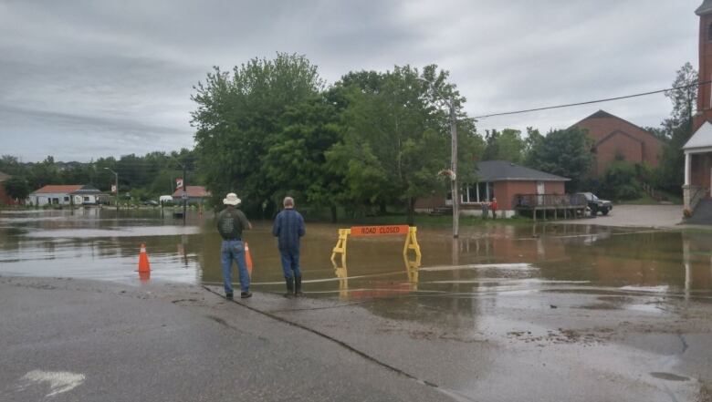
Flooding in Elora, West Montrose, New Hamburg after 100mm rainfall
Grand River Conservation Authority has issued flood warnings for numerous areas

Ontario's Grand River Conservation Authority has issued flood warnings for parts ofthe City of Kitchener, Cambridge and North Dumfries,theTown of Grand Valley, Township of Mapleton, Township of Centre Wellington and Township of Woolwich. Brantford was also included later Friday in the flood warnings and watches.
Information on:
- Kitchener
- Cambridge and North Dumfries
- Brantford, Brant county
- Grand Valley
- Elora
- Harriston
- St. Jacobs, West Montrose, Elmira
- New Hamburg, Ayr
Late Friday, New Hamburg was added to the list of threatened communitiesas the NithRiver was included on the list of waterways swollen by early Friday's rain.
It comes after 100 millimetres of rain fell in the northern part of the Grand River watershed between 3 and 5 a.m. Friday.
"The heavy rainfall has resulted in a rapid rise in river levels across the northern portion of the watershed," the authority wrote in an advisory Friday.
In some areas,such as the Glasgow Street bridge inWoolwich Township and Highway 24 south in Cambridge, the floodwater flows arenearing levels not seen for over 40 years.
The following areas are under theflood warning:
Town of Grand Valley
According to GRCA, flows through Grand Valley peaked late Friday morningand are now receding. Flows will remain high through the weekend, the agency said,and continue into early next week.
There are multiple road closures within the Town of Grand Valley.
According to the GRCA, flooding in that area "is expected to be similar to flooding that occurred in December 2008."
#flooding #GrandValley Keep dogs and children away from rivers and streams! @OrangevilleWX @weathernetwork @Lyndsay_CTV @AnthonyFarnell pic.twitter.com/Z6SFzkzES0
—@KirkMacDonald5Flooding in grand valley surging out into road and keeps getting deeper #onstorm. River is raging @KirkMacDonald5 pic.twitter.com/awAhUcx9rk
—@KayBeWxVilliage of Drayton
- Part of the Villageof Draytonis in a Level 3 flood area. Water levelspeaked early Friday afternoon and are receding, but GRCA reported Saturday that flows will remain high all weekend.
Elora
Flows through Elora peaked on Friday afternoon, GRCA reported on Saturday.
Discharge from Shand Dam is reduced. As the reservoir level is brought back withinnormal operating range, flows will remain high GRCA said.
"Flows of this magnitude were last experienced in May 2000," the GRCA said Friday afternoon.
"The river is crazy high,"Kathy Sullivan, the co-owner ofCafe Creperiein Elora, told CBC Kitchener-Waterloo on Friday.
"There's a GRCA buoy going down the river right now....a big, white buoy, and it's about to go over the falls. It has no choice, I guess it got loose somehow."
Sullivan said her shop is fine so far, but people on other sections of Mill Street have been bailing out their basements most of the morning.

St. Jacobs, West Montrose, Elmira, Conestogo Golf Course
TheGrand River through WestMontrosepeaked Friday evening, the watershed authority stated Saturday.
- The Three Bridges Road bridge upstream of St. Jacobs is closed, and is expected to remain closed through the weekend.
- Glasgow Street in Conestogois closed for the weekend. "Flows of this magnitude have not been experienced since May 1974," the GRCA said.
- High water levels are expected to flood parts of theConestogoGolf course. The GRCA is advising thegolf course to raise the pedestrian bridges that cross the Grand River.
- Nodamage to buildings is expected in the Town of Elmira, though there will be flooding of the municipal park downstream of Arthur Street, said the GRCA. "Flows will be high along the Canagagigue Creek through Elmira. Arthur Street and Bolender Park are flooded," GRCA reported Friday afternoon. "Crews are on-scene to maintain the closure. Flows of this magnitude were last experienced in June 2004."
- GRCAsaid discharge fromConestogoDam has been reduced, however flows will remain very high as the reservoir level is brought back within a normal operating range.
- WoolwichReservoir discharge has been reduced, however flows through Elmira will remain elevated as the reservoir level is brought back within a normal operating range.

Conestogo River flows are expected to peak Friday afternoon or early evening, but will stay high through the weekend.
Levels through West Montrose are expected to peak later Friday evening.
Canagagigue Creek levels will run high through the Town of Elmira.
City of Kitchener
The GRCA updated its flood warning information Saturday morning, stating "lows are peaking through Bridgeport and Doon Saturday morning in the 900 m3/s range."
The agency stated that the river flows would "remain extremely high through the weekend."
BingemanTrailer Park flooded Friday.
A spokeswoman for Bingemans said it's uncommon for the park to see flooding at this time of year, "but we have moved all our campers to higher ground."
Reminder if you come upon a flooded road while driving, turn around. Most cars can be swept away by less than 2ft of MOVING water
—@mintofiredeptA less serious flood watch is in place for the Grand River south of Cambridge. The conservation authority said flows will be higher than usual through the rest of the weekend.
Cambridge, North Dumfries
Saturday morning the GRCAsaid it expected theGrand River flows through Cambridge to peak around noon, reaching the 900 m3/s range. The authority said usually in the summer, water flows atthis location should be in the 15 m3/s.
"Flows of this magnitude in the Grand River through Cambridge have not been seen since April 1975," the authority reported.
Also, sections ofHighway 24 between Concession Street and Myers Road are flooded. Blair Road between Fountain and George Streets, are flooded. These sections would remainclosed until Sunday, GRCA said.
Also, the Everglades Trailer Park south of Cambridge was expected to flood late Friday or early Saturday.
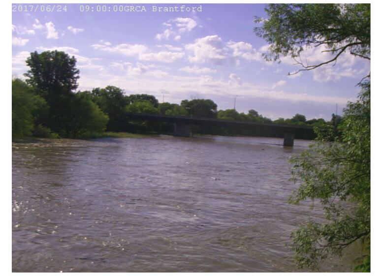
County of Brant,City of BrantfordandHaldimand County
Flows are expected to increase through Brantford overnight on Fridayand peakon Saturdayafternoon, said GRCA.
- Brantford flood co-ordinators wereasked toclose Gilkinson Streeton Saturdaymorning.
- Trailer park residents in Brant Park were advised to expect flooding and should be prepared to evacuate trailers in areas of the park if flooding occurs.
- Brant County and Six Nations flood co-ordinatorswere asked to maintain the closure ofBoundary Road between Six Nations and Brant County.
- Haldimand County officials are asked to warn residentsintrailer parks on the southern Grand River watershed that they may have toevacuate trailers in areas typically prone to spring flooding.


_(720p).jpg)


 OFFICIAL HD MUSIC VIDEO.jpg)
.jpg)


