Major flood risk remains for Red, lower Assiniboine and other southern Manitoba rivers
Severity of flooding depends on precipitation over next few months
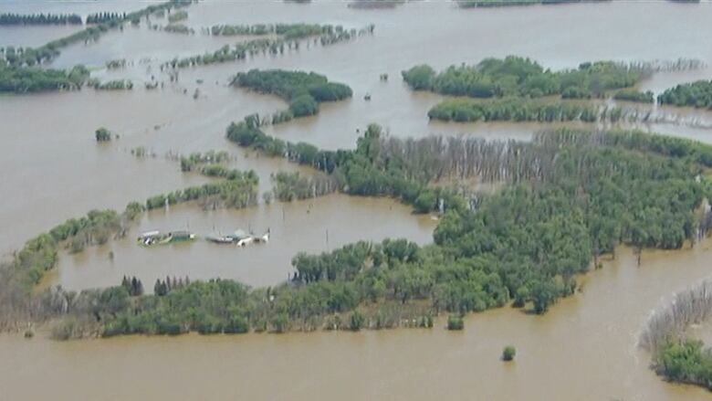
There remains a major risk of flooding this spring in southern Manitoba, despite the recent thaw that melted much of the snow upstream along the Red River drainage basin.
Provincial flood forecasters say they will be watching the weather closely over the next two months because the presence or absence of precipitation will determine the degree of flooding.
In the first formal flood outlook of 2017,Manitoba Hydrologic Forecast Centre director Fisaha Unduche said there remains a major risk of flooding along the Red River, Roseau River, Souris River and the lower portion of the Assiniboine River.

The recent thaw eliminated most of the snowpack upstream along the Red River, but also saturated the soil, making it less able to absorb runoff from more meltwater or rain, he said.
"It slightly reduced the flood potential but at the same time makes the soil more saturated. So if we get normal precipitation in March it could be translated to bigger runoff," Unduche said.
- Soggy soil could mean spring floods in west, north
- Don't trade that snow shovel for a sandbag-filler just yet
- Southwestern Manitoba faces high risk of spring floods
Lakes in Whiteshell Provincial Park are also at risk of major flooding, he said. But it all depends on how much rain or snow falls in the coming months.
If there's average precipitation in the coming months, the flooding should not create lengthy highway closures.
"If you can order another March just like January and February, we would be in much better condition then,too. But keeping in mind there is a potential for this [flood]. So we have to prepare," Infrastructure Minister Blaine Pedersen said.
The Red River in Winnipeg is expected to crest within a week at about 15 feetabove normal winter ice level at James Avenue, the level of a moderate flood,as melt from the recent thaw south of the border reaches the city.
A second, larger crest of 17 to 19.5feet James is expected after all the snow in the basin melts. That would be a moderate spring flood, similar to what the city experienced in 2005 and 2007.
Ice, however, could push the Red River up to 22 feet James, a level that would require extensive sandbagging along low-lying Winnipeg properties.

In early December, the combination of extremely wet soil-moisture conditions, above-normal water levels and a snowy winter forecast led Manitoba Infrastructure's hydrologic forecast centre to state there is a "probable chance of moderate to major flooding at some locations" in southern Manitoba this spring.
In the January forecast, provincial flood forecasters refined that outlook to state the Red, Pembina, Souris, Roseau and lower Assiniboine rivers are at risk of major flooding this spring.
They peggedflood concerns along the upper Assiniboine River, Winnipeg River and parts of eastern Manitoba as moderate to major.
Southern Manitoba has received a lot of snow this winter, but snow accumulationis just one factor among several that determines whether a flood will occur and how severe it will be.
The other factors include soilmoisture at freeze-up, lake and river levels, frost depth, the rate of snowmelt and the precipitation during snowmelt, hydrologists and meteorologists say.


_(720p).jpg)


 OFFICIAL HD MUSIC VIDEO.jpg)
.jpg)


