Red River forecast to hit 2011 flood levels with average weather, could go as high as 2009
Thick ice means jams are possible, but cold weather followed by quick melt is greatest threat
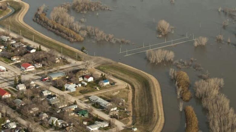
Major flooding on the scale of2011 is expected along the Red River in Manitoba this spring, with a deluge around the level of the more severe 2009 flood possible if the weather does not co-operate in March.
In the first detailed flood outlook of the year, provincial forecasters are warning of widespread overland flooding along the Red River, with flows south of Winnipeg around the volume of the 2011 flood, even if temperatures and precipitation in March are close to average.
This would mean farmland would be inundated, some communities along the Red River would either prepare or use their ring dikes,and Highway 75 south of Morris could be closed for several weeks, hydrologic forecasting director Fisaha Unduchesaid.
Less favourable weather for example, a lot of rain or snow, orcold weather followed by a sudden and rapid melt could bring about a Red River flood on the scale of 2009, the second-highest flood crest since the construction of the Red River Floodway, after the 1997 flood of the century.
Under both scenarios, low-lying properties in Winnipeg would require sandbag-dike protection and the city would be required to enact other flood-mitigation measures, such as closing off drainage outflows into its rivers.
The greatest threat right now is very cold temperatures throughout March, followed by a rapid melt that would create crests before ice moves off the Red River and out of the floodway diversion channel, Infrastructure Minister Ron Schuler said.
Below-normal temperatures are in fact expected in March and April, forecasters said, meaning the ground could remain frozen longer and less able to absorb runoff once the melt occurs.
"It means that water, rather than going into the ground or evaporating, then would start flowing very fast," Schuler said.
Cold weather this winter has created thicker-than-average ice, which the province is testing right now.
This means there is ahigher risk of ice jams, which are difficult to predict and can lead to rapid and highly localized increases in water levels.
What happens in March will dictate the severity of the Red River flood, Schulersaid, adding all communities along the Red River Valley have measures in place to deal with flooding on the scale of a 2009 event.
Moderate flooding along Assiniboine
Flooding is expected to be moderate along theAssiniboine River and Souris River this spring, with agricultural farmland expected to be inundated. Communities along these rivers, however, are not expected to see water levels above flood protection levels, provincial officials said.
The province plans to open the Shellmouth Dam to help mitigate flooding along the AssiniboineRiver and use the Portage Diversion to send some of the Assiniboine's flow into Lake Manitoba once ice has moved off the diversion channel.
The Red River Floodway control structurealso may not be used until ice moves off its diversion channel.
The province is not predicting high lake levels this spring but is predicting moderate flooding on the Saskatchewan River and Carrot River.
Schuler said municipalities will receive more technical information about what's expected and the public will be updated as needed.


_(720p).jpg)


 OFFICIAL HD MUSIC VIDEO.jpg)
.jpg)


