Montreal and surrounding municipalities have new flood maps but won't make them public
Updated maps show flood risk along the Mille les, Des Prairies rivers, but they may not be adopted for months
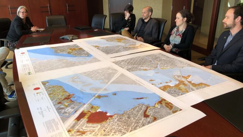
The organization overseeing Montreal-area municipalities has created state-of-the-art flood maps, but themunicipalities concerned have yet to adopt them and likely won't for months.
Until it does, rules for building permits and home construction will continue to be based on outdated informationin the communities that dot the Mille les River and the Rivire des Prairies.
That also means homeowners wondering whether their property is in a new flood zone will have to wait to find out.
Suzy Peate, executive co-ordinatorfor planningat the Montreal Metropolitan Community (CMM), says even if the maps aren't yet adopted, municipalities should at least be telling their residents about them when issuing permits.
"I think they have the obligation to advise their citizens," said Peate. "You have the zoning bylaw, but you have to give out all the information that you do have."
- What are flood maps, and why are they important?
- Province orders Quebec municipalities to come up with plans in responseto 2017 floods
Up-to-date portrait due by 2020
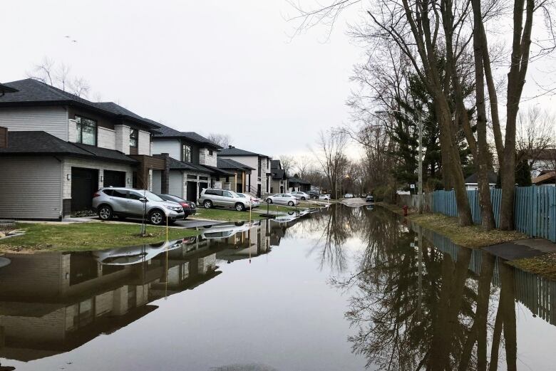
This spring's historic flooding has hit more than 100 Quebec municipalities, damaging more than 7,000 homes.
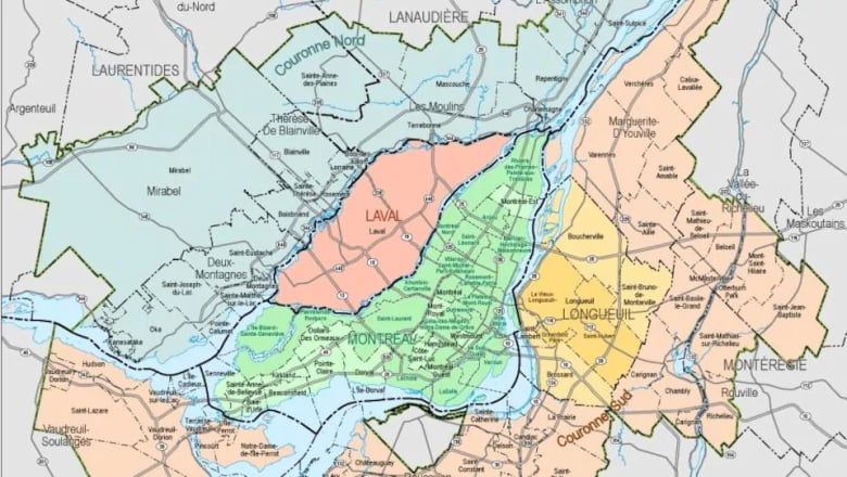
The catastrophic events have lentnew urgency to the CMM's task of creating and releasing a complete, up-to-date flood risk portrait of the Hochelaga archipelago the islands at the confluence of the St. Lawrence and Ottawa rivers, which include Montreal.
The CMM received $5.5 million from the province's Public Security Ministry do the job. It's expected to be completed in 2020.

But as part of that effort, maps of the Mille les and Des Prairies rivers have already been drawn up, based on data gathered by scientists, engineers and cartographers.
The CMM won't release them to the public, saying that's up to municipalities, but it isn't opposed to them doing so.
"If they want to distribute the information in their city, they are allowed to do so," said Peate.
Maps still to be 'validated'
None of the municipalities who told CBC News they had the new maps would make them public.
A spokesperson for Laval, Louis-Philippe Dorais, said the maps still have to be "validated."
He says they are trying to shed light on what are sometimes "important" differences between the new maps and existing ones, and he doesn't expect them to be formally adopted by the city until the end of 2019, at the earliest.
Youssef Amane, a spokesperson for Montreal's mayor and executive committee, says sharing the maps now is "impossible" because there's still work to be done to complete them.
The regional county municipality of Les Moulins in Lanaudire, which includes the cities of Mascouche and Terrebonne, referred CBC News back to the CMM, as did the City of Terrebonne.
Rosemre, which hugs the north shore of the Mille les River, says it doesn't have the new maps, and it's working off 2005 data.
The City of Deux-Montagnes, on the Lake of Two Mountains, did not respond to CBC's information request.
New maps also show volume of water
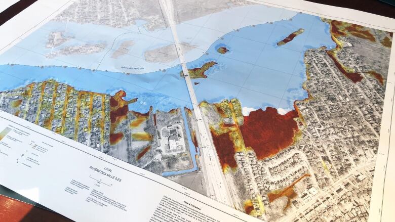
The new maps, which use data from 2014 and beyond, show not only the limits of the high-velocity (0 to 20 years) and low-velocity (20 to 100 years) flood plain zones, as in previous cartography, but also have colour-coded visualizations of just how high waters could be expected to rise in specific areas.
"A classic map just says it's wet or it's dry," said Brent Edwards, a CMM geographical information system manager. "Having, like, a centimetre of water or a metre of water there's a huge difference."
The new maps were produced by a team of specialists with LIDAR (Light Detection and Ranging) technology, which uses lasers to map the riverbeds.
Edwards said LIDAR provides a more complete portrait of how water flows will impact an entire waterway or system of waterways, and it's more accurate than having surveyors map lots on a permit-by-permit basis, as is currently the practice in places like the Montreal borough of le-Bizard-Sainte-Genevive.
LIDAR also allows cities to accurately project onto the map various water-level scenarios, like those seen in 2017 and 2019, to determine where water will accumulate, Edwards said.

Cities already using maps for emergency response
The revisions which Montreal and Laval spokespeople say still need to be done involve adding information about municipal drainage infrastructure, in order to complete inland areas of the maps, said the CMM.
But just because their new maps don't have every detail and aren't yet official doesn't mean they're inaccurate or not useful, it said.
Municipalities now dealing with intense flooding are already using the maps for emergency planning purposes, as is the province's Public Security Ministry, said the CMM.
In Saint-Eustache, on the north shore of the Mille les River, all city employees, including police and firefighters, have access to the maps through the city's centralized geomatics system. However, the city said it won't release them to the public because they are considered "working documents" and are not officially part of city regulations.
Denis Trudel, a consultant for Saint-Eustache's urban planning division says it's up to the municipal regional county, the MRC of Deux Montagnes, to pass a new regulatory framework which includes the new maps, so Saint-Eustache can update its own building codes.
"We've been pushing for several years to get adequate information, so everyone is in agreement," Trudel said.
Until then, he said, his city must follow the MRC's "interim" regulatory framework, which relies on flood zone data from as far back as 2005.
Right now, if someone asked him for a permit to build in a 100-year flood zone he'd authorize it, provided it had a flood-proof basement, he said.
"I'd give him the permit. It's allowed in the regulations," said Trudel.
Let's build 'resilient neighbourhoods': CMM head
The CMM says that situation of issuing permits based on outdated maps may change, depending on what the provincial government decides to do in the aftermath of this spring's flooding.

"It's time to redo the map" and stop new construction in flood-prone zones, saidPremier Franois Legaultthis week.
The CMM is suggesting the province use its new maps when the waters recede and it comes time to talk about who should be allowed to rebuild in flood zones.
"It's always the most recent information that is of interest," said Peate. "Using old maps and different maps for all the territories isn't in the interest of our citizens."
CMM Director General Massimo Iezzoni says even if municipalities haven't yet officially adopted the new maps, the province could bypass the process by issuing a provincial decree.
Failing that, the CMM could also override the hodgepodge of municipal flood zone guidelines by embedding them in its metropolitan plan, which would immediately make them legal across its territory.
Iezzoni said the era of every municipality having its own map is over, and it's time for all municipal governments in the region to agree on a master plan to build "resilient neighbourhoods" based on uniform data.
"I can't say everyone loves our maps, but now it's science talking,' he said.


_(720p).jpg)


 OFFICIAL HD MUSIC VIDEO.jpg)
.jpg)


