Flooding forces widespread road closures in New Brunswick
Roughly 3 dozen Fredericton roads remain closed, more southern roads added to the list of closures
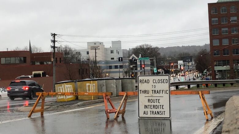
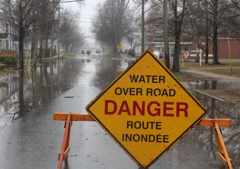
Widespread flooding throughout the provincehas left many roads under water and closed to traffic, as communities grapple with rising rivers.
The Fredericton area has been hit the hardest, with roughly three dozen barricaded city streets and nearly 20 highway or rural road closures in the region. But there's an increasing number of highwayand municipalroad closuresin southern New Brunswick.
A list of road closures can be found below.
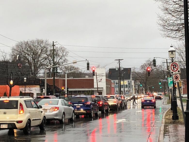
Commuting in the capital
John Lewis, the city's traffic engineer, said the combination of road closures and parking lots being flooded has made commutes very difficult.
Only two city-owned parking lots are open: Frederick Square and the east end parking garage.Fredericton is down by more than 800 parking spaces in total, according to a news release from city hall.
"This is one of the more challenging transportation issues that we've had to deal with for quite some time," Lewissaid.
As a result, the city was encouraging people to walk or bike to work or find other alternate ways of getting to the office.
City buses are free, and the city has also set up park-and-ride shuttle services on the city's north and south sides. Shuttles will run continuous service from6:30 a.m. to 9:30 a.m, and again from3:30 p.m.to 7 p.m., from these locations:
- Brookside Mall pickup, drop-off location at Queen andWestmorlandstreets.
- Willie O'Ree pickup, drop-off location at Queen andWestmorlandstreets.
- Grant Harvey Centre pickup, drop-off location York andBrunswick streets (Brunswick Street Baptist Church).
- Regent Mall (former Sears location) pickup, drop-off location York andBrunswick streets (Brunswick Street Baptist Church).

TheWestmorlandStreet Bridge and Princess Margaret Bridge are still open.
City roads that are closed are:
- Lincoln Road at City Limits (Baker Brook).
- Carleton Street at Queen Street.
- Water over road onWinslowand Alexandrastreets and University Avenue.
- Shore Street.
- Riverside Drive atGibson Street andat Route 8.
- Sunbury Drive.
- Carleton Street.
- Brunswick Street.
- Burpee Street.
- Cityview Avenue.
- Morrell Park.
- River Streetunder walking bridge.
- Devonshire Drive.
- Union StreetatGibsonStreet.
- Saint Anne Point Drive.
- Wilsey Roadat Kimble Drive.
- Vanier Highwayat Slip Lane to Lincoln.
- Forest Hill at Slip Lane to Lincoln.
- Waterloo Row Overpass.
- Lincoln Road at Waterloo Row.
- University Avenue at George Street.
- Church Street.
- King Street at Saint JohnStreet.
- Lincoln Road at theExperimental Farm.
- York Street atQueen Street;
- Union Street off ramp.
- Main Street off ramp.
- Smythe Street off ramp.
- Lincoln Road at Vanier Industrial Park.
- University Avenue atCharlotte Street.
- BurpeeStreet at Floral Street andat Hildebrand Street.
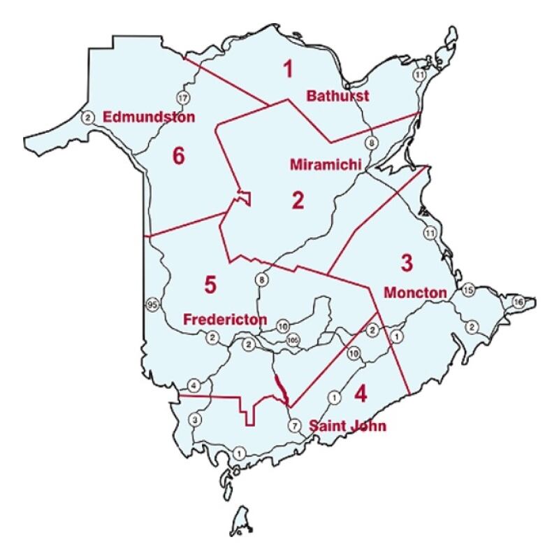
District 5 - Fredericton area
- Route 690 Pond Stream Roadto Douglas Harbour Road.
- Route 105 between Route 107 and Kinney Road.
- Route 101 Central Blissville, 280 meters north of the intersection with Branch Road.
- Route 105 with detour in both directions using Allison Road and Hunter Road then back on to Route 105.
- Route 105 below Hartland,detour on Route 575 and Rideout Road.
- Route 105 from the Princess Margaret Bridge to McGowan's Corner.
- Tweedside Road closed for 8.9 km from Route 3 Brockway.
- The Tripp Settlement Road in Keswick Ridge for 1.5 kmfrom Route 105.
- Kenneth Roadin Glassville from West Glassville Road to West Cross Road.
- Campbell Hill Road in Carlow from civic number 60 to West Glassville Road.
- Frasier Road in Brighton between Mainstream Road and Ashland Road.
- DuplisseaRoad in Central Blissville, 280 meters north of Brach Road intersection.
- Rusagonis Road between Sunpoke Road and Rusagonis Stream Bridge.
- Route 102 in Central Hampstead, near PelvinRoad.
- Route 102 in Swan Creek, south of Burton Bridge.
- Dorn Ridge Road, reduced to one lane in gravel section.

District 6 - Edmundstonarea
- Route 105 Salmon River Bridge area between Lucy's Gulch and Cantello.
- Labrie Road Between Rang 9,10 Road and Guimond Road, full closure for2 km.
- Rang 3 Road fromMyrlangto David Road, dirt road section.
- Route 105 2.4 kmnorth of Route 109.
- Route 380 closed 500 metres north ofLebelRoad.
- Route 144 from Edmundston city limits to Riviere-Verte and between civic number 1785 and 1795 in Saint-Leonard-Parent.
- Nadeau Road in Baker Brook between Joseph Mornault Road and Grand-Reed Road.
- Tinker Road in Tinker off of Route 130.
- LabrieRoad in Saint-Quentin between Rang 9 and 10 roads and Guimond Road.
- Ed Theriault Road in Rivire-Verte500 metres from Rivire Quisbis Road.
- Pleasant Street in Aroostook 100 metres from Berry Road.
- Riley Brook North, near Route 385 in Riley Brook.
District 4- Saint Johnarea
- Lower Norton Shore Road in Lower Norton.
- Beulah Camp Road in Browns Flat.
- Darlings Island Road in Darlings Island.
- Station Loop Road, from Route 100 to first house in Nauwigewauk.
- Lawrence Long Road in Saint John.
- Dominion Park Road in Saint John.
- Beach Road in Saint John.
- Bay Street in Saint John reduced to one lane near South Bay culvert.
District 2 - Miramichiarea
- Mullin Stream Road, 600 metres south of Gale Hill on gravel section.
District 1 - Bathurst
- Mathilda Road in Middle River 150 metres from the Middle River Road.
- Mines Road from Route 430 to Nepisiquit Falls Road intersection.
- Gloucester Junction Road on the upper part of gravel section.


_(720p).jpg)


 OFFICIAL HD MUSIC VIDEO.jpg)
.jpg)


