Winter weather wallop headed straight for the Maritimes again
Up to 40 cm of snow is expected on Wednesday in some parts of the province
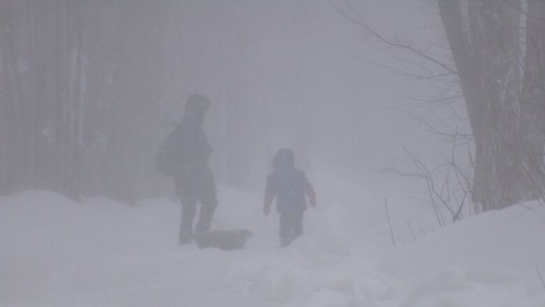
Another nor'easter is headed straight for the Maritimes this week and it's bringing a blast of heavy snow, strong winds and rain to New Brunswick.
Kalin Mitchell, a CBC meteorologist, said the storm is expected to hit Tuesday, bringing as much as 40 centimetres of snow to central and northern New Brunswick before it ends Wednesday.
Along with the snow, will come wind gusts up to 90 km/h in some areas, which will make driving hazardous.
"Due to the strong winds, there will be periods of blowing and drifting snow thatwill reduce visibility," Mitchell said.
- Nor'easter to slam East Coast with snow, heavy rain, strong winds
- Work, travel disrupted as nor'easter whips province
- Fredericton teen profits from digging people out of storms
Environment Canada issued a winter storm watch for most of the provincethis week as the third nor-easterinfive days approached the region.
Snow is expected to start Tuesday in southern and southwest New Brunswick. About15 cm of snow ispossible by late Tuesday afternoon with additional amounts likely by Tuesday night.
Snowcould change to rain along the Fundy coast by Tuesday night.
The storm will spread north and northeastward in the afternoon, bringing 10 to 20 cm Tuesday night to Fredericton, Moncton, Woodstock,Grand Falls, Edmundston, Campbellton and Bathurst.
Additional snow may fall into Wednesday.
Snow, snow and more snow
The worst of the snowfall could occur near the end of the storm Wednesday, Mitchell said.
"Areas of western Nova Scotia and New Brunswick in particular could double up on the Tuesday snowfall amounts by the end of Wednesday," said Mitchell.
Poor weather conditions could contribute to transportation delays, Environment Canada said.
Danielle Elliott, a spokesperson with EMO,said inthese types of weather events, residents should be prepared for any type of emergency, including apower outage.
She said New Brunswickers are reminded to have everything they need for at least 72 hours following a storm.
Residents should have emergency kits in their homes and cars, and they should include:food, water, radios, batteries, first-aid supplies and any special items they might need.
She also advised drivers to stay off the roads, because they will be snow-covered and visibility will be poor.
New Brunswick forecast
Northern New Brunswick
Today: A mix of sun and cloud with isolated flurries or showers. Northeasterly winds will be travelling between 10 km/h and 20 km/h. Temperatures will be at a high near 2 C.
Tonight: Partly cloudy in the evening with increasing cloudiness overnight. Northeasterly winds will be travelling between 10 km/h and 20 km/h. Temperatures will drop to a low of 6 C.
Tuesday: Increasing cloudiness with snow and blowing snow developing in the evening and overnight. Between 10 cmand 20 cm of snow is expected for the area. Northeasterly winds may reach 50 km/h in the evening. Temperatures will be at a high near 1 C.
Fredericton and area
Today: A mix of sun and cloud and temperatures will be at a high near 4 C.
Tonight: Increasing cloudiness and temperatures will be at a high near3 C.
Tuesday: Cloudy with snow and blowing snow developing late in the morning. Snow will continue throughout the afternoon and evening and could become mixed with ice pellets or rain.
Snowfall amounts will range between 10 cm and 20 cm. Northeasterly winds may reach 40 km/h and gusting up to 60 km/h in the evening. Temperatures will be at a high near 1 C.
Southern New Brunswick
Today: A mix of sun and cloud with northeasterly winds travelling between 10 and 20 km/h. Temperatures will be between 1 and 4 C.
Tonight: Increasing cloudiness with scattered flurries. Northeasterly winds will be travelling between 10 and 20 km/h. Temperatures will be at a high near4 C.
Tuesday: Cloudy with snow and blowing snow developing in theafternoon. Snow mixing with ice pellets or rain near the Bay of Fundy coastline in the afternoon.
Snowfall of as much as 20 cm is expected, except along the Bay of Fundy coastline where 10 cm is expected.
Northeasterly winds will be travelling between 40 km/h and 70 km/h. The high temperatures will be 3 C.


_(720p).jpg)


 OFFICIAL HD MUSIC VIDEO.jpg)
.jpg)


