Road closures and flooding: Here's what you need to know
The province is looking to implement a resource road so residents can get in and out of Chipman
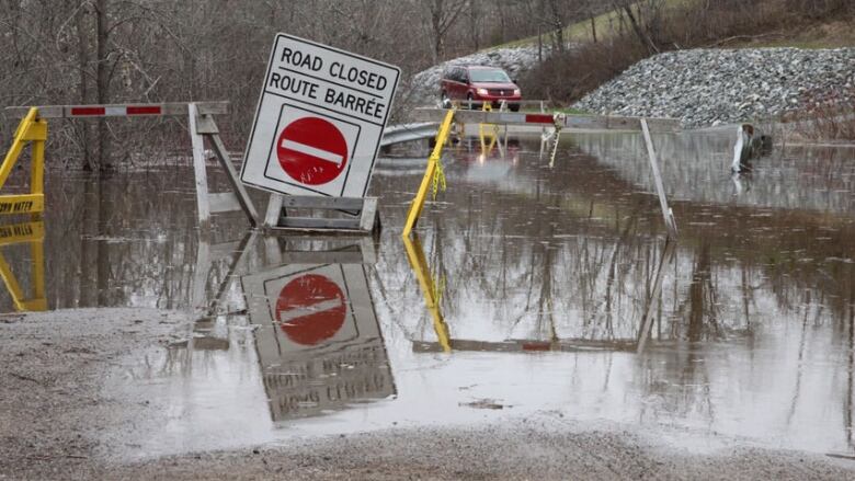
An increase in waterspillingonto the roadhas forced the provinceto close Route 10 in Chipman, N.B.,Saturday afternoon.
"We are currently working with industry to bring a resource road to a standard that would enable emergency vehiclesor other vehicles to get in and out of the community," saidAhmedDassouki, director of operations with the Department of Transportation and Infrastructure.
Meanwhile, theTrans-Canada Highway between Fredericton and Moncton could be closed untilnext week, according to an official with the company that operates the highway.
- On mobile? Follow our live coverage here.
- Water levels expected to reach 'historic highs' in southern New Brunswick
The Trans-Canada closure started shortly after 7 p.m. on Thursday and affects both eastbound and westbound traffic.
"That is expected to continue throughout the weekend and into the next week," Dassouki said.
"Water is now up to the centre line on both lanes and high winds are causing some waves on the roadway."
Moreroadshave beenclosed acrossNew Brunswick as water levels continue to rise on the St. John River. The province has asked residents to avoid flooded roads and to respect barricades that close off flooded areas.
Road closures in Fredericton
- Lincoln Road at city limits (Baker Brook)
- Carleton Street atQueen Street
- Water over road onWinslowand Alexandra streets and University Avenue
- Shore Street
- Riverside DriveatGibson Street
- Riverside DriveatRoute8
- Sunbury Drive
- Carleton Street
- Brunswick Street
- Burpee Street
- Cityview Avenue
- Morrell Park
- Riverside Drive
- River Streetunder walking bridge
- Devonshire Drive
- Union Street atGibson Street
- Saint Anne Point Drive
- Wilsey Road at Kimble Drive
- Vanier Highwayat Slip Lane to Lincoln
- Forest Hill, Slip Lane to Lincoln
- Waterloo overpass
- Lincoln Road atWaterloo Row
- University Avenue atGeorge Street
- Church Street
- King Street atSaint John Street
- Lincoln Road atthe experimental farm
- York Street atQueen Street
- Union Street off ramp
- Main Street off ramp
- Smythe Street off ramp
- BurpeeStreet atFloral Street and at Hildebrand Street
- Lincoln Road at Vanier Industrial
- University Avenue atCharlotte Street
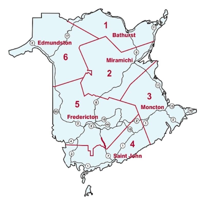
District 5 - Fredericton area
- Route 690 Pond Stream Road to Douglas Harbour Road
- Route 670 from Cow Pasture Brooke between Ripples and Lakeville Corner
- Route 105 between Route 107 and Kinney Road
- Route 101 CentralBlissville, 280 metres north of the intersection with Branch Road
- Route 105 with detour in both directions using Allison Road and Hunter Road then back on to Route 105
- Route 105 below Hartland, detour on Route 575 and Rideout Road
- Route 105 from the Princess Margaret Bridge to McGowan's Corner
- Route 105 from intersection of route 104, fourkilometres going west, water over road
- Tweedside Road closed for 8.9 km from Route 3 Brockway
- The Tripp Settlement Road in Keswick Ridge for 1.5 km from Route 105
- Kenneth Road in Glassville from West Glassville Road to West Cross Road
- Campbell Hill Road in Carlow from civic number 60 to West Glassville Road
- Frasier Road in Brighton between Mainstream Road and Ashland Road
- Duplissea Road in CentralBlissville, 280 metres north of Brach Road intersection
- Rusagonis Road between Sunpoke Road and Rusagonis Stream Bridge
- Route 655 at civic 770 to intersection at Rusagonis
- Merritt Smith Road from the intersection of Mills Road north to the end of the road
- NeversRoad from civic 554 to the intersection of Route 655
- Route 714 from the intersection with Route 10 to the intersection with FowlderRoad
- Route 710 between Highway 10 to Starkey Intersection
- Cow Pasture Brook between Riplles and LakevilleCorner
- Waasis Farm Road at the intersection of Nevers Road
- Mills Road from civic 130 to 150.
Please respect road closure advisories. Your safety - and that of the first responders who will need to rescue you - depends on it. pic.twitter.com/ihUatoLjxV
—@NBEMO_OMUNB- Route 102 in Central Hampstead, near Pelvin Road
- Route 102 in Swan Creek, south of Burton Bridge
- Dorn Ridge Road, reduced to one lane in gravel section
- Waterville Road, 30 metres south of Maple Street in GearySunburyCounty
- Route 123 from Chipman Village Limits to Stevenson Road
- Backland Road between Back Greenfield and Greg Settlement dirt road
- McKeaghan Road between Charleston Road and chipseal, about 1.5 kilometres
- Route 116, from Route 123 to Briggs Corner Road
- Starkey Covered Bridge on Starkey Road from Route 10 to Route 710
- Smith Road in Waterville closed at intersection with Waterville Road
- Post Road between Midland Road and Chipman
- Route 104 reduced to one lane around civic 228 and 246
- Route 102, 100 m from Upper HampsteadRoad
- Route 705 in Wickham area from Bald Hill intersection to Kings-Queens county line
- Route 710 in Wickham area from Big Cove to Route 705 intersection
- Route 715 in Waterborough area, five km of Fowler Road intersection
- Robinson Point Road in Waterborougharea
- Fanjoy Point Road in Waterborough area
- Craft Cove Road in Wickham area
- Route 10 at Coal Creek, civic number 8234 to 8286
District 6 - Edmundston
- Petit-Quest Road, from intersection of L'Acadie Road to Range Bye Roadabout 3.4 kilometres
- Riley Brook North, near Route 385 in Riley Brook
- Nadeau Road in Baker Brook between Joseph Mornault Road and Grand-Reed Road
- Route 380 closed 500 metres north of Lebel Road
- Route 144 fromEdmundstoncity limits to Riviere-Verte and between civic number 1785 and 1795 in Saint-Leonard-Parent
- Pleasant Street in Aroostook 100 metres from Berry Road
- Little River #1 Bridge in the Parish of Denmark
- Route 105 between Lucy's Gulch Road and Cantello Road in the Salmon Bridge area
- Iroquois River #3.5 Bridge in Edmundston
- Quisibis River #2 in the Parish of Saine-Anne
District 4 - Saint John area
- Lower Norton Shore Road in Lower Norton
- Beulah Camp Road in Browns Flat
- Darlings Island Road in Darlings Island
- Station Loop Road, from Route 100 to first house in Nauwigewauk
- Route 850 from Erb's Cove to Whiting Lane
- Route 850 from Upper Midland Road to Rogers Road
- Brittain Road from route 177 to McKenzie Road
- Milkish Creek Road between civic #125 to #142
- McKenzie Road at Woodsman's Point
- Sunset Valley Road at Woodsman's Point
- West Tenants Cove Road in Springfield
- Browns Cove Road near Kars
- Elms Road in Kars, from Ferry Road to Route 705
- Route 845, Moss Glen from Neck Road to Piper Town Road
- Route 124 in Springfield from Route 710 to Route 695
- Porter Road from Route 100 to Old Road
- Route 102 closed from Grand Bay-Westfieldfor five km before the Evandale Ferry
- Route 745 at Beaconsfield Road, dirt section only
- Route 850 fromKeirsteadville Road to Whiting's Lane
- Route 850 from Route 124 to KeirsteadvilleRoad
- Woodsman Point Road at Woodsman Pointfrom Civic 41 to road's end
- Route 124 from Morolle Road to Valley Road
- Lawrence Long Road
- Dominion Park Road
- Ferry Cover Road
- Westfield Road at 1370
- Mellinger Crescent at culvert
- Greenhead Road at Randolph Bridge
- PokiokRoad
- Spar Cove Road
- Ragged Point Road
- KennebecasisPoint
- Bravo Landing (Millidgeville)
- Beach Road
- Bloomfield Station Road between Route 121 and Centennial Road
- Passekeag Road from Centennial Road to River Road
- Harding's Point Landing Road from civic number 62 to the ferry landing
District 2 - Miramichi area
- Mullin Stream Road, 600 metres south of Gale Hill on gravel section
- Bloomfield Ridge Road, one kilometre from chipseal on gravel section
- StoreytownRoad tothe Big Hole Brook in the Doaktownarea
- Priceville Road between Storeytown and Priceville
District 1 - Bathurst
- Mathilda Road in Middle River 150 metres from the Middle River Road
- Mines Road from Route 430 to Nepisiquit Falls Road intersection
- Gloucester Junction Road on the upper part of gravel section


_(720p).jpg)


 OFFICIAL HD MUSIC VIDEO.jpg)
.jpg)


