Dorian winds whip western Newfoundland, as storm tracks toward North Atlantic
Wind 'big issue of the day,' as storm moves out to sea by Sunday night

Post-tropical storm Dorian is expected to move through western Newfoundland and off into the North Atlantic Sunday night, afterknocking trees into power lines and toppling fences Sunday afternoon and walloping the Maritime provinces the day before.
Hurricane warnings issued by Environment Canada have been downgraded to tropical storm warnings for much of the western and southwestern regions of Newfoundland, as well as the Northern Peninsula.
Doug Mercer, senior meteorologist with the Canadian Hurricane Centre, says Dorian is expected to have moved into the North Atlantic by Sunday night.
"This evening, around 9 or 10 p.m., it will have passed northeast of the Strait of Belle Isle and it will be heading out to sea," he said.
"But [winds]will still be fairly high, overnight will be when you really start to see things starting to drop off."
Mercer saidwinds will be back to normal ranges by Monday morning.
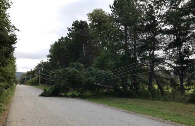
Newfoundland Power tweeted it had received multiple reports of trees being blown over and knocking into power lines along parts of the west coast.
Les vagues la marina de Cap St-George, film vers 10h30 ce matin #nlwx #icitnl #icinb @CBCNL @iciacadie #Dorian2019 pic.twitter.com/ufwGf03T9U
—@MarieIsabelleRoAs estimated 3,500 customers were without power at peak times, with the number gradually lowering asNewfoundland Power said its crews are atvarious stages of repairs.
"Most of the damage has been caused by large, heavy trees being blown into the power lines due to the extreme high winds from Dorian," said Michele Coughlan in an emailed statement.
"In some cases the trees have brought down power lines and broken poles."
Nasty morning out on the Gulf of St. Lawerence. #nlwx pic.twitter.com/2ustXvMIZw
—@cgsseaGusts were forecast to reachup to 150 km/hin coastal areas throughout the day Sunday.
Wind warnings were extended late Sunday morning to include the Bonavista region.
"That's going to be the big issue of the day," said Mercer.
The wind and possibility of storm surges later on Sunday are the main points of concern, Mercer said, as the storm's centre moves through the Strait of Belle Isle by around 3 p.m. NT.
The storm is tracking its way over the eastern Gulf of St. Lawrence Sunday morning, before moving up to the Northern Peninsula in the afternoon.
In Stephenville and along the Gulf of St. Lawrence, people were reporting increasingly gusty winds, as well as rain starting late Sunday morning.
"You're going to have a band of southwesterlies that are forecast to be hurricane force, and as the storm moves up into the Strait and nears the coast, those winds are going to be picking up," he said.
"The strongest winds, I would expect, would be somewhere near Corner Brook, moving up toward the Parson's Pond-Hawke's Bay region, then it may drop off a little bit as it gets up toward St. Anthony."
Those high winds gave Don Rideout a bit of a scare overnight, when a neighbour called to say there was a broken window at his mother's house nearby.
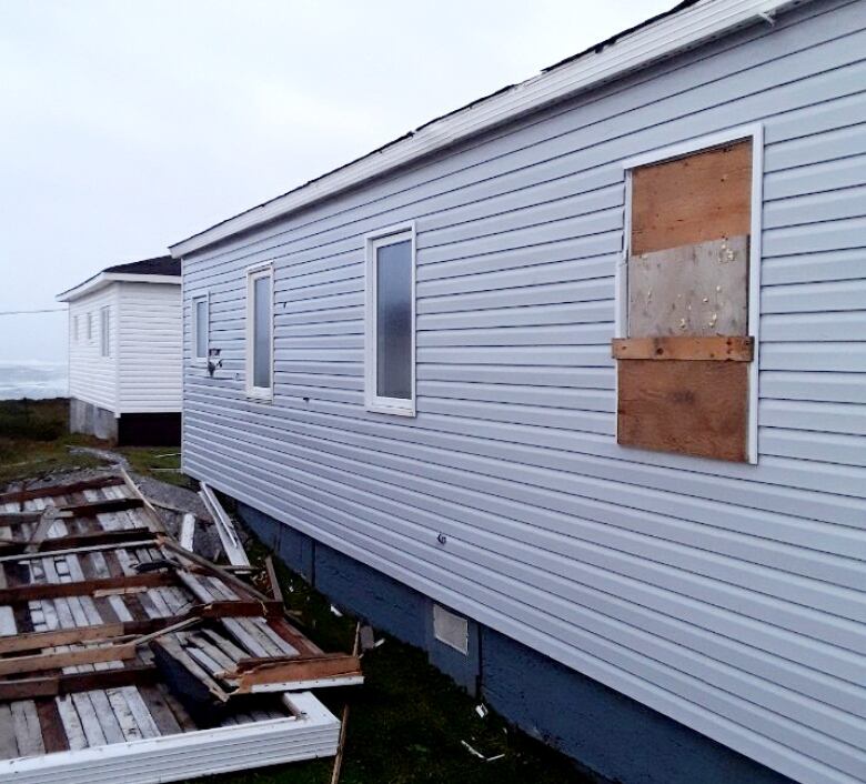
Rideout said the neighbour spotted a curtain blowing out through a broken window, so Rideout went over to see what had happened.
"I thought it was a bridge at first or a patio on the ground by the side of mom's house there, so I went on inside and when I went in there was glass everywhere and the window was all gone," Rideout said.
His mother, 89, had taken her hearing aid out to go to sleep, and hadn't realized what had happened.
"She was wondering why the bed was shaking so much," Rideout said, of the wind gusting through his mother's house.
Rideout took a closet door from his mother's room and boarded up the broken window from the inside, waiting until daylight to get someone to come and seal it more safely from the exterior.
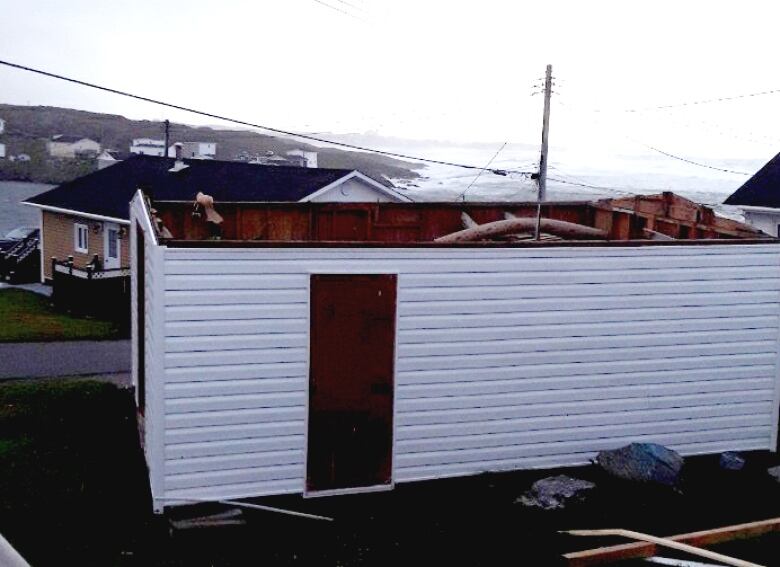
In the meantime, Rideout said the debris that had struck his mother's house was from a neighbour's garage.
"The roof blew off and came over and hit the side of mom's house, and had all kinds of damage on the siding there and busted out the window, too," he said.
Rideout lives along the Port aux Basques shoreline, and had worried about the storm surges at high tide around 7 a.m. NT. But, he said, the surges weren't bad; he did notice there's a fair amount of scattered debris along the coast.
High wind in the area isn't unusual, but Rideout said this weekend's gusts were very powerful.
"I don't know, it's like the winds are different, they're packing more of a punch or something," he said.
"We've had higher winds here I've been in the house with 160, 170 [km/h] winds, but I don't know what's happening lately."

Not much rain
Power outages due to high winds werereported in the Rose Blanche area, as well as in Pasadena and along the north shore of the Bay of Islands, according to the Newfoundland Power website.
The outages were also reported headed into central Newfoundland regions.
Crews were working throughout the late morning and early afternoon to restore customers, amid the high winds.
Rainfall amounts are not expected to be high, Mercer said, adding the area where the most rain can be expected is the south coast of Labrador.
In Irishtown-Summerside. Power out. Wind up to crazy gust levels. #nlwx #dorian pic.twitter.com/g1ya4UEFgP
—@CBCbirdAs the storm moves northward, winds will make their way further inland into the Baie Verte Peninsula, and possibly into the Bay of Exploits, Mercer said.
By 9 p.m., Dorian's storm system will be tracking north of St. Anthony before moving off into the North Atlantic.
Waves will be between four and seven metres due to Hurricane Dorian, Environment Canada says.
Marine Atlantic's scheduled crossings for Sunday have been cancelled and moved to Monday.
Overnight Saturday,heavy rain caused some water buildup on roads in parts of Newfoundland.
Dorian wreaked havoc through the rest of Atlantic Canada on Saturday, toppling trees, blowing roofs off homes, and even knocking over a massive industrial crane onto a building in the middle of Halifax.
Another video, some water building up on the roads from the heavy rain. #nlwx #grandfallswindsor #dorian pic.twitter.com/nXspptj42f
—@parsonscl90It whipped through Nova Scotia as a Category 2 hurricane, with gusts up to 141 km/h; the warning was diminished toa post-tropical storm around 7:30 p.m. NT as it made landfall in Halifax.
Hundreds of thousands ofcustomers in Nova Scotia were without power Sunday morning, according to Nova Scotia Power's outage listing website.
The Dorian storm system had whipped through coastal areas of North and South Carolina last week, after tearing through the Bahamas.
The storm had destroyed more than 13,000 homes and is being blamed for more than 40 deaths in the Bahamas.
With files from Troy Turner


_(720p).jpg)


 OFFICIAL HD MUSIC VIDEO.jpg)
.jpg)


