Hurricane Fiona could track over western Newfoundland, Nova Scotia this weekend
Meteorologists say storm will bring hurricane-force winds, urge people to be prepared
Western Newfoundland and parts of Nova Scotiaare in the possible path of Hurricane Fiona, which battered Puerto Rico over the weekend, causing catastrophic damage to the islandandleaving people without power or water.
The hurricane also tore through the Dominican Republic on Monday, bringing torrential rain, flooding and strong winds, andkilling at least two people.
CBC meteorologist Ashley Brauweilersays Fionais the first major category hurricane of the season. As of Tuesday morning it was churning close toTurks and Caicos with sustained winds of 185 km/hand gustsup to 220 km/h.
"It's a pretty strong Category 3, and actually over the next couple of days it's expected to become a Category 4 hurricane,"Brauweilersaid Tuesday.
2am AST 20 Sep -- Air Force Reserve Hurricane Hunter (@53rdWRS) data indicates that #Fiona has become a Category 3 hurricane. Fiona is the 1st Major Hurricane of the 2022 Atlantic Hurricane Season.
Maximum sustained winds are up to 115 mph.
Latest: https://t.co/EG1Nt92Czm pic.twitter.com/GCk9dyiE7d
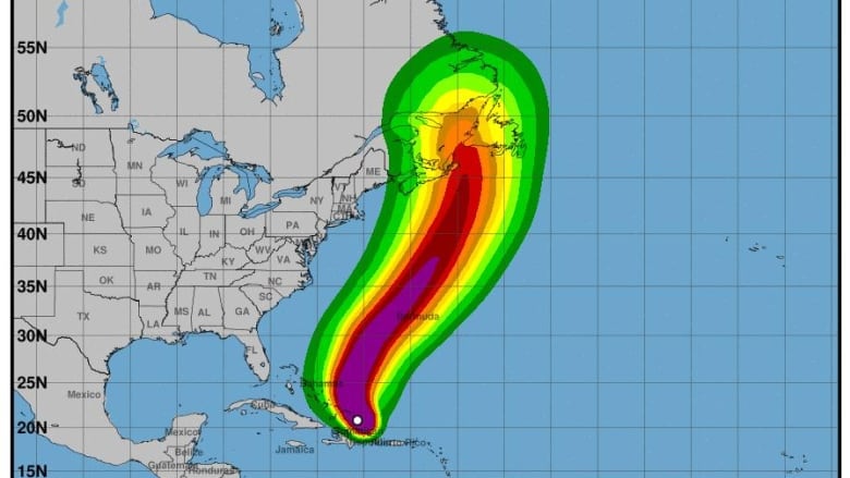
—@NHC_AtlanticAs the hurricane swirlsnorth toward Atlantic Canada, forecasting models have shifted Fiona'strack 200 kilometres west, withparts of Newfoundland and Labrador and Nova Scotianow in the possible path ofthe hurricane on Friday evening through Saturday.
"Even just that overnight shift that's a significant shift for the the Atlantic area," said Brauweiler.
Meteorologist Rodney Barney of Environment Canada's weather office in Gander agreesbut with the hurricane still days away from possible landfall, he said, there is still a lot of uncertainty.
"Right now the cone is showingFiona coming up from the south, andthe cone stretchesfrom Nova Scotia to the south coast of Newfoundland. So the track could be anywhere within that cone," he said.
5am EDT Tuesday, 20 September Key Messages for Major Hurricane #Fiona.
Hurricane conditions expected for Turks & Caicos this morning & tropical storm conditions for southeastern Bahamas.
Interests in Bermuda should continue to monitor Fiona's progress.https://t.co/EG1Nt93aoU pic.twitter.com/Fdh4vymuuk
—@NHC_AtlanticWhile it's too early for meteorologists to predict Fiona's final track, or put numbers to wind speeds,rain amounts and storm surges, bothBrauweilerand Barneysaid the storm will likely bring hurricane-force winds in excess of100 km/h.
However, Brauweiler said the heaviest rain is always to the left of a hurricane's track and the strongest winds are typically to the right.
Because of the impending storm, Marine Atlantic said it anticipates cancelling ferry sailingsbetween Port aux Basques, N.L., and North Sydney, N.S., betweenFriday andSunday. The Crown corporation said it would provide updates whenpossible and has added two extra crossings on Wednesday and Thursday before thestorm will have any effect on the region.
"The best thing to do at this point is just prepare. No need to panic," said Brauweiler.
People in the hurricane's probable track should put away patio furniture, trim tree branches, and prepare emergency kits with 72 hours' worth of essentials in case the power goes out, she added.
"Really strong wind gusts on the south coast that, with storm surge, is not something we like to see," cautioned Brauweiler.
For now, she says, models show the southern and western parts of the islandmay get more wind than rainbut can still expect a significant amount of downpour that could lead to road washouts.
Barney said the entire province of Newfoundland and Labrador will feel the storm's effectsbut western Newfoundland will see the strongest wind.
At this point, he said, he thinks the storm will pass relatively quickly.
With files from The St. John's Morning Show


_(720p).jpg)


 OFFICIAL HD MUSIC VIDEO.jpg)
.jpg)


