How artificial intelligence and lasers could make the seas safer
'Equipment can be sent in more dangerous areas' instead of people
Hydrography the study of surveying and mapping out the ocean floor drew 200 people to the Delta Hotel in St. John's this week.
To seafaring Newfoundlanders,the importance of mapping out coastal areas is well understood. Knowing where shallows are is crucial to avoid grounding ships and endangering life aboard.
However, because of this risk, many shallower seas are literally uncharted waters.
ALiDARsends laser beams down to the ground, and penetrates the water, and maps the seabed floor.-Dennis Hall,Quantum Spatial
Paul Brett, the head of the school of ocean technology at the Marine Institute in St. John's, was one of the organizers of the conference. He explained that one of the main goals of this new technology is safety.
"You could lose a vessel, you could lose people, if the ship hits a rock or hits some uncharted areas where there's a hazard to [navigate]," said Brett.
"So those are the key pieces that we're looking for. And autonomous vehicles, of course, do not have people aboard, so it's equipment, and equipment can be sent in more dangerous areas."
Laersas asolution
To deal with the complexities of shallow seas, differentcreative solutions were showcased at the conference.
Dennis Hall,who works with the U.S-based company Quantum Spatial showed off the capabilities of bathymetric LiDAR the technique of shooting lasers from a plane.
"A LiDAR sends laser beams down to the ground, and penetrates the water, and maps the seabed floor," explained Hall.
Other international companies presented autonomous vessels that can collect data independently for days on end, and amphibious "bottom-crawler" robots that can mount instruments or even perform rescue missions.
Autonomous vehicles, of course, do not have people aboard, so it's equipment, and equipment can be sent in more dangerous areas.- Paul Brett, Marine Institute
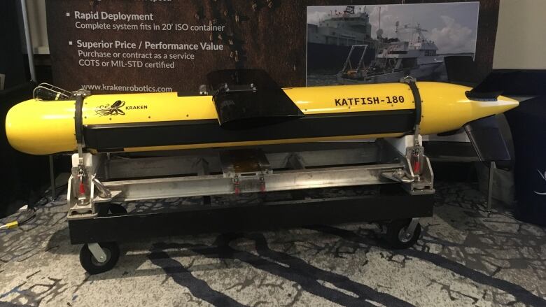
Brian Carroll from Kraken, a St. John's-based robotics company, stood in front of a bright yellow torpedo called the Katfish. The probe is meant to be towed behind ships and can capture the seafloor with a resolution of up to three centimetres.
"Defense measures, for sure, is one of the big reasons for the high resolution that we need," explained Carroll.
"You're trying to look for something that's less than a metre in diameter on the seafloor, conventional side-scan is just not going to find that."
A.I. and the Hydroball
In a speech, Genevive Bchard, Canada's hydrographer general from the Department of Fisheries and Oceans (DFO), highlighted the government's investment into artificial intelligence and autonomous vessels, but also pointed out the importance of crowdsourcing data from remote locations.
One technology that aims to make crowdsourcing seafloor data accessible to everyday Canadians is the HydroBall by Quebec-based company M2Ocean.
We'll bring you to Shallow Survey Conference 2018. Hear how #coastal Canadians are helping piece together the map of the #sea floor in the ocean's shallow water. Tune in 6pm. #hydrography #bathymetry #unknownocean pic.twitter.com/0WaACFaUft
—@TheBroadcastCBCThis beach ball-sized buoy can be deployed behind recreational vessels, and automatically collects data with little engagement from the vessel operator and the system has several advantages. One of those is helping to improve existing maps, and therefore decreasing people's risks at sea.
"Because this technology is so quick to learn, and doesn't have an overhead of requiring a particular crew or particular type of vessel to accommodate it, we're leveraging the local communities into using their own platforms, their own boats, their canoes, their dories," said Kevin Wilson, the CEO ofM2Ocean.


_(720p).jpg)


 OFFICIAL HD MUSIC VIDEO.jpg)
.jpg)


