High snowpack, water levels put several N.W.T. communities once again at risk of spring flooding
Snow levels around the Hay River basin are at the highest level ever recorded at this time of year
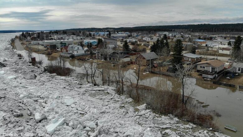
Excessive snowpack and highwater levelshave communities across the N.W.T. at risk of flooding once again this spring.
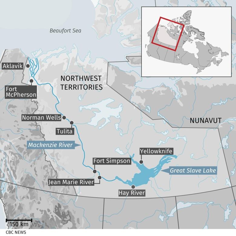
This includes Hay River, Kt'odeeche First Nation, Nahanni Butte, Fort Liard, Fort Simpson, Aklavik, Fort Good Hope, Tulita and Jean Marie River First Nation.
The N.W.T. government released a technical report on Monday which saidthere is potential for spring breakup flooding once again this spring.
This comes after last year's devastating floodingleft numerous homes damaged or destroyed in several communities across the N.W.T.
In an email highlighting key takeaways from the report, the territorial government saidice jams during breakup can cause flooding regardless of the water levels. However, high water levels increase the severity of the flooding.
High riskon Hay, Mackenzie,LiardandPeel River
Water levels in the Hay River Basin are at or near the highest ever recorded at this time of year as much as 40 per cent higher than normal levels in Alberta and B.C.
This is combined with an already saturated ground which increases the risk of smaller bodies of water overflowing.
Higher than normal water levels have been recorded around Aklavik and high snowpack is reported aroundthe Peel River and the Mackenzie Delta.
Snowpack aroundthe Liard River, which was the main cause of last year's flooding in Fort Simpson,is approximately 56 per cent higher than normal.
Throughout the Dehcho, Saht and Beaufort Delta, there is potential for ice jam flooding on the Mackenzie River which could be exacerbatedby high snow volumes in the area, as well as higher-than-average water levels and water flow in the river.
Ice jams unpredictable, but not inevitable
Although the water levels and snow buildup can increase the severity offlooding, ice jams are the main cause of flooding during breakup, something that isunique to the North.
And ice jams are difficult to predict.
Ryan Connonis a hydrologist with the territorial government.
He said there are two ways the ice can break up there is the "the good way" or thermal, where the sun slowly melts the ice.Then there's the bad way, mechanical,when thethere is thick ice near flood risk communities andrapid snow melt in other parts of the basin, that quicklymoves towards the river.
"What that will do is it that will push up the ice on the edges of riverbanks and it will break up the ice a little bit and when those large chunks of ice move further downstream and if it hits thick solid ice that hasn't melted yet, that's how you get the ice jams," Connon said.
It's unknown if ice jams will form until breakup starts, which he expects will be in the next week or two.
With files from Shannon Scott


_(720p).jpg)


 OFFICIAL HD MUSIC VIDEO.jpg)
.jpg)


