'This is a big deal': Dorian makes landfall in Halifax as a post-tropical storm
Most of the region on alert, under hurricane, tropical storm and rainfall warnings

Hundreds of thousands of residents in Atlantic Canada are without power after Dorian blew through the region, knocking down trees anda crane while stirring up large waves.
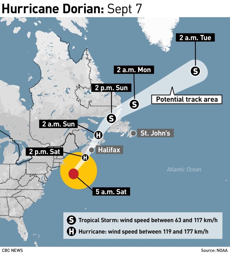
Dorian made landfall in Halifax shortly after 7 p.m. as a post-tropical storm, but had previously been a Category 2 hurricanewith wind gusts of 141 km/h hitting parts of Nova Scotia.
"This storm is just a huge storm," said CBC meteorologist Tina Simpkin. "This is a big deal."
Updated Maritimes Timeline
Strong winds slowly ease from west to east tonight, as #Dorian tracks into the Gulf.
Still blustery for PEI, Northumberland Shore & Cape Breton Sunday morning, with winds easing in the aft.
Some sun for clean up Sunday aft.#nsstorm #nbstorm #pestorm pic.twitter.com/C09pcaz3Ge
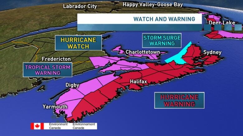
—@ryansnoddonMost of Atlantic Canada is under a combination of weather warnings:
- Hurricane,tropical storm and rainfall warnings for much of Nova Scotia;
- Rainfall warnings for New Brunswick;
- Rainfall, wind, storm surge and tropical storm warnings for P.E.I.;
- And hurricane, tropical storm and wind warnings for Newfoundland and Labrador.
Environment Canada is warning of flooding along the coast due to storm surges and pounding surf. The Halifax Regional Municipality called for residents who live along the shoreline in some areas to leave their homes.
By 8 p.m. Saturday, more than 348,000 customers were without power in Nova Scotia.
Ralph Goodale, Minister of Public Safety and Emergency Preparedness, tweeted on Saturday afternoonthe Canadian Armed Forces are mobilizing to deploy to assist with recovery after the storm moves through.

Environment Canada is cautioning thatwinds will cause significant damageand lead to extended power outages.
"We've seen some really significant impacts with storms that were weaker than this one," said meteorologist Bob Robichaud."So, widespread trees being uprooted, broken trees, lots of roof damage, all those sorts of impacts which also include potential for prolonged power outages are all very likely at this point."
As the storm headed northeast toward the region on Saturday morning, it was moving at 41 km/h the fastest it hadtravelled since it formed, said Simpkin.
The prime minister also said he had been briefed on the storm and that Ottawa would be willing to help.
Just received a briefing with @HarjitSajjan, @RalphGoodale and @CDS_Canada_CEMD about the latest information on Hurricane Dorian. The safety of Canadians is our number one priority and were ready to help Atlantic Canada through this storm.
—@JustinTrudeauNova Scotia
Simpkin said the eye of the hurricane is expected to hit somewhere between Lunenburg, N.S., and Sheet Harbour this afternoon around suppertime, and Robichaudsaid landfall is likely to occur near or just to the east of Halifax.
By mid-morning, the storm was starting to be felt in southwestern Nova Scotia, with winds already gusting to 90 km/h, or what Environment Canada calls "warning criteria."
Rain will spread across Nova Scotia today, with 100 to 150 millimetres expected over western areas, and 200 millimetrespossible in some local areas. Over central and northwestern parts of the province, 60 to 120 millimetres are expected.
Rain will taper off from southwestern portions of the province to the northeast between Saturday night and Sunday morning.
In Cape Breton, close to 50 millimetresis expected to fall over the course of the storm.
Winds will be strong throughout the mainland, withsustained winds of about 100 km/hr and gusts up to 120 km/h later in the day. Gusts along the coast could reach 150 km/h.
In Cape Breton, winds will be 70 km/h gusting to 110 km/h, with gusts of up to 130 km/h along the coast.
New Brunswick
Southern New Brunswick will see the bulk of the impact of Dorian compared with northern parts of the province. Fifty to 70 millimetres of rain is expected in the south over the course of the storm more than post-tropical storm Erin brought to the area last week, according to Robichaud while 20 to 30 millimetresis forecastfor the north.
The strongest winds from Dorian will be felt east of New Brunswick, but winds in the south of the province will be 50 km/h gusting to 80 km/h this afternoon, and 70 km/h gusting to 100 km/h after midnight.
In northern New Brunswick, winds will be about 40 km/h gusting to 60 km/h.
Prince Edward Island
The Island will see heavy rain starting early this afternoon, with 30 millimetresor more in the afternoon and an additional 40 millimetresor more in the evening.
Winds will be 30 km/h gusting to 60 km/h in the afternoon, increasing to 50 km/h gusting to 90 km/h tonight.
Newfoundland and Labrador
Western and northern parts of Newfoundland, as well as the southern tip of Labrador, are facing hurricane or tropical storm warnings.
Winds are expected to gust up to 150 km/h in some coastal areas on Saturday evening and 120 km/h early Sunday morning.
Storm surges of up to one metre are forecasted, with wavesreaching up to seven metres.
Follow the live weather blog
Keep up to date on Hurricane Dorian with the CBC Maritimes live weather blog, updated every day.
With files from CBC meteorologist Tina Simpkin and Frances Willick


_(720p).jpg)


 OFFICIAL HD MUSIC VIDEO.jpg)
.jpg)


