October's highs and lows, and that record snowstorm in 1974
Fall in the Maritimes means being at the mercy of jockeying air masses, says CBC meteorologist Kalin Mitchell

While the province is currently on track to experience one of our milder Octobers on record, it is important to realize that this month has historically been one of how do I put this? "variable" weather.
In fall, the Maritimes are at the mercy of a number of different air masses, which are regions of the atmosphere with unique temperature and moisture content,all jockeyingfor position across continental North America.
Cold, dry air begins to break down from the north in waves while warm, humid air can still move up the Eastern Seaboard in southerly winds.
This is why rain, snow, sun, cloud, warmthand cold snaps are all likely to be experienced during our fall season, and sometimes only hours apart.
Warmer air is winning out this October.
But that wasn't the case Oct. 20, 1974, a day where record snowfall was experienced in much of the province.Here's what happened:
Early in the week of Oct. 13, 1974, a wave of cold Arctic air broke down over Hudson Bay. That cold air was directed into the Maritimes by northwest winds left in the wake of a storm system that moved into Labrador.
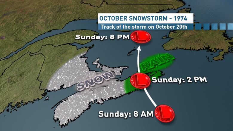
The same colder air moved to a position along the Eastern Seaboard of the United States, creating the perfect setup for a very early season nor'easter, which isjust what happened.
A low-pressure system just off the southeastern U.S. developed rapidly and moved to a position near Sable Island by earlySundaymorning. From there, the storm continued to strengthen as it moved across Cape Breton and into the Gulf of St. Lawrence. This was the perfect track to wrap moisture into the cold air above southwestern Nova Scotia, creating an October snowstorm.
The snowfallnumbers wereimpressive:
- Halifax: 38.6 cm
- Yarmouth: 37.6 cm
- Greenwood: 29.5 cm
- Kejimkujik: 27.9 cm
- Annapolis Royal: 25.4 cm
- Shelburne: 20.3 cm
- Truro: 17.5 cm
Most of those are record amounts for an October snowfall.
'Visibility was zero'
Many other areas in the southwest of the province experienced a snowfall of 20-40 cm, such as Liverpool where resident Fred Giffin recalls the storm.
"During the morning, as I took my daughters for a toboggan ride along the street, a sudden 'thundersnow storm' began," he said in an email. "With that, like other thunderstorms, the snow was so heavy that visibility was zero and I took the girls back into the house.In Liverpool, my estimate of the snowfall was 31 cm."
Northeastern areas of the province were spared the brunt of the snow as they ended up on the warm side of the storm. Instead, they experienced a heavy rain. Strong winds and the heavy snowfall alsocontributed to widespread power outages in Nova Scotia.
Is there October snow shovelling ahead this year? It doesn't appear so as the month is likely to wrap up much like it started, with unusually warm conditions.


_(720p).jpg)


 OFFICIAL HD MUSIC VIDEO.jpg)
.jpg)


