Bundle up it's about to get dangerously cold in Nova Scotia
The whole province is under an extreme cold warning from Environment Canada
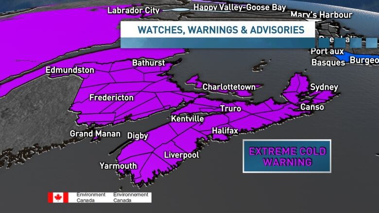
Frigid temperaturesand windsFriday and Saturday areshaping up to be the coldest winter weather eventfolks in Nova Scotia have experienced in many years, withEnvironment Canada issuingan extreme cold warning for the whole province.
Wind chill values will reach dangerously low levels across the Maritimes Friday night and Saturday.
School closures
Some schools are closed Friday.
On the mainland, all schools in the Annapolis Valley, Cumberland County and Digby County are closed.
For Conseil scolaire acadien provincial(CSAP) schools, cole Rose-des-Vents in Greenwood and all schools in Clare are cancelled.
In the Cape Breton-Victoria Regional Centre for Education, schools north of Smokey are closed.For the schools that are open, buses will only be operating on paved roads this morning and afternoon.
Forthe Strait Regional Centre for Education, buses are also only travelling on paved roads. Classes are cancelled at the Cape Breton Highlands Education Centre and Pleasant Bay School due to weather conditions.
Temperatures will start out rather mild on Friday morning, with southwest winds.

A cold front will then swing through the province and temperatures will plummet throughout the afternoon. By dinnertime, expect wind chill values in the 20 to 30 range.
Winds will continue to strengthen and the temperatures will continue to drop Friday night.
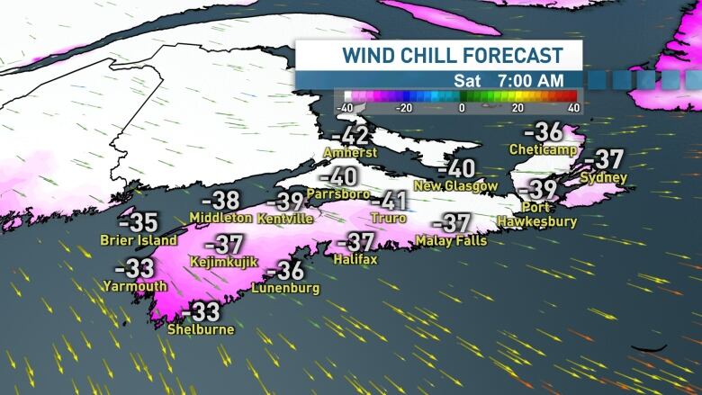
By Saturday morning, temperatures will bottom out in the low to mid 20s, with wind chill values making it feel more like 35 to 40 across Nova Scotia.
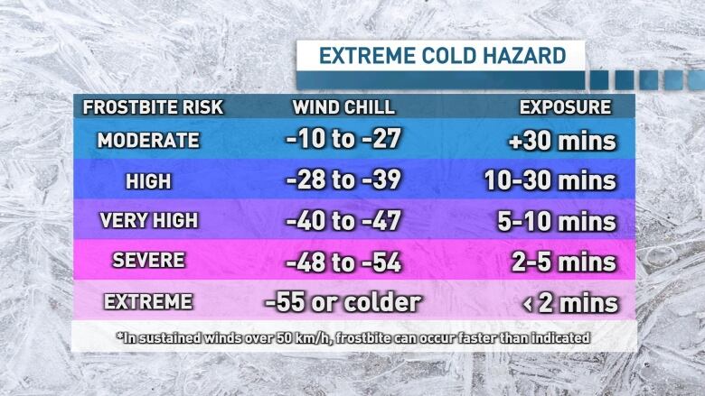
Frostbite can occur in as little as 10 minutes in theseconditions, so be sure to bundle up if you are heading outside.
Hypothermia is also possible if exposed to this type of cold for too long.
The last time we had a similar event was February 2015. During that Arctic air outbreak, we experienced wind chill values drop to the 30 to 35 range across much of Nova Scotia, P.E.I. and New Brunswick.
We have to go back nearly 20 years to January 2004 to find the last time the wind chill dipped below 35 in the Halifax metro area. Wind chill values dropped to40 in Charlottetown and Saint Johnthe same year.
While the temperatures will slowly rebound throughout Saturday, northwest winds gusting 60 to 80 km/h will keep wind chill values in the 25 to 35 range on Saturday afternoon.
Those strong northwest winds will also trigger onshore flurries to develop and bring the risk of snow squalls Friday night and Saturday.
Drivers should be prepared to encounter snow and blowing snow, particularly in theTri-County area, Annapolis Valley, NorthumberlandShore region and across Cape Breton.
The winds and flurries will ease through Saturday night then shift to southwest, with temperatures set to rise throughout the day on Sunday.


_(720p).jpg)


 OFFICIAL HD MUSIC VIDEO.jpg)
.jpg)


