Winter driving season begins Friday in the Maritimes
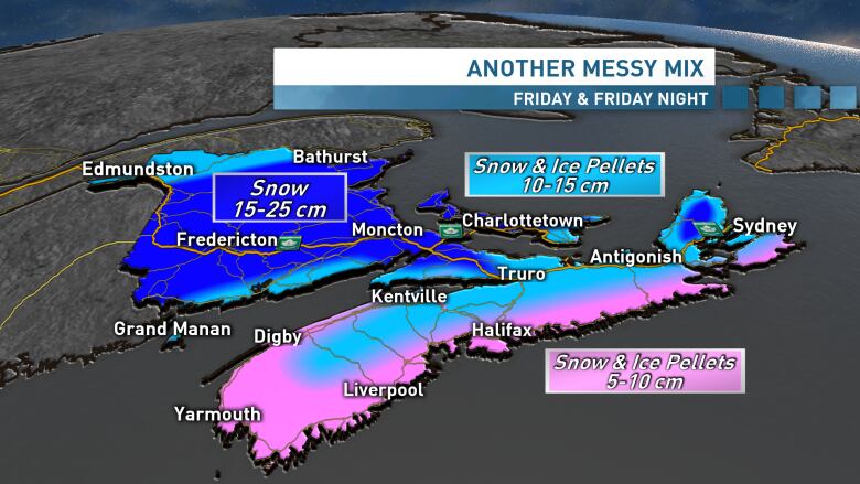
First accumulating snowfall for much of Nova Scotia, significant snow for much of New Brunswick
It's the most wonderful time of year... winter driving season!
While Friday's storm won't be a major event for this neck of woods, the first widespread accumulating snowfall is always one that brings a few challenges, especially on the roads.
Timing
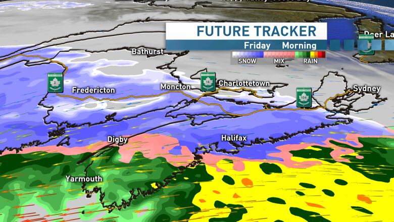
We'll see the snow move into southwest Nova Scotia and southwest New Brunswick through the early morning hours of Friday, arriving in the Halifax and Fredericton regions through the busy 6 a.m. to 9 a.m. commute time. The snow will continue to spread in across the rest of the region through the morning. Easterly winds will strengthen with gusts 40-50 km/h as the snow moves in.
Maritimes Timeline
Snow arrives in southwest Nova Scotia & New Brunswick in the early morning hours of Friday, moving into #Halifax and #Fredericton through the morning commute. A sloppy drive home for most of Nova Scotia, a snowy drive for New Brunswick.#nswx #nsstorm #nbstorm pic.twitter.com/txTgEWIk8Z
—@ryansnoddonThe mix from snowto a couple of hours with ice pellets, then over to rain and drizzle, will start in southwest Nova Scotia mid-morning, before transitioning in the Halifax region around lunch time. Northern areas of Nova Scotia, as well as the Fundy coast of New Brunswick will also see a mix to ice pellets and rain through the afternoon. Southeasterly winds will increase during this transition with gusts 50-70 km/h.
It's certainly looking like a sloppy drive home on Friday across most of Nova Scotia and a snowy drive home in New Brunswick.
Friday evening brings a transition from snow to rain across Cape Breton, while mainland Nova Scotia will see a mix of showers and flurries as winds shift back to northwest. Steady snow tapers to light snow then flurries across New Brunswick.
Messy roads in P.E.I. too
CBCP.E.I. meteorologist Jay Scotland says he expects flurries to arrive on the Island bylate morning with steadier snow moving in for the early afternoon.
Steady snow could see roads become messy through the mid to late afternoon before tapering off in the late evening. Snow and ice pellet amounts look to generally fall in the 10-20 cm range across much of P.E.I., with as much as 25 cm possible for parts of western Queens County and Prince County.
Winds will also increase through the day with easterly winds from 40 km/h to over 70 km/h possible by the late afternoon which could restrict travel options for folks heading off Island.
Long range
The weekend looks quiet but cool across the region and the below average temperatures are set to continue right through next week. There's even another chance for snow mid-next week!
I'll have an update on the chilly outlook and the latest on the incoming system tonight on CBC-TV at 6pm.
Follow the live blog
Keep up to date with myweather blog, which is updated every day.
With files from Jay Scotland


_(720p).jpg)


 OFFICIAL HD MUSIC VIDEO.jpg)
.jpg)


