Snowy, icy, windy Wednesday: An hour-by-hour breakdown of what to expect from storm
Mix of snow, ice pellets, freezing rain, rain and gusty winds on Wednesday
This story was originally published Tuesday, Feb. 12, 2019.
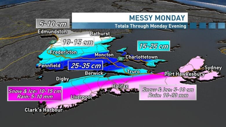
As has been the case all winter, thisweather system is bringingyet anotherround of snow, ice pellets, freezing rain, rain and wind to Nova Scotia through the day Wednesday.
Most schools across the province are closed and many flights have been cancelled. Travel will be impacted for most of the day, so here's a breakdown of what you can expect and when.

6 to10 a.m. Snowy morning commute
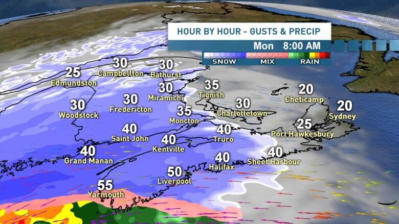
During the morningcommute, we'll see the snow and winds ramp up with gusts 60-80 km/h for the Halifax region and across much of central Nova Scotia.
Snow on the roads with blowing snow and reduced visibility will make ita difficult commute for most.
At the same time, snow will be mixing with ice pellets and even some freezing rain over southwest Nova Scotia. Winds will be gusting 70-100 km/h over the southwest and wind warnings are in effect.
The snow begins during the commute over north and eastern Nova Scotia, as well as Cape Breton.
We'll see a lot of ice pellets mixing in with the snow across the Maritimes on Wednesday.
Some freezing rain likely too.
Here's a quick refresher on snow vs ice pellets vs freezing rain vs hail. #nsstorm #nbstorm #pestorm pic.twitter.com/J1kZs1m3V7
—@ryansnoddon10 a.m. - 3 p.m. Ice, ice baby

Snow will mix to ice pellets across most of mainland Nova Scotia aroundmidday. Shovelling or walking outside will be flat out unpleasant(if not painful!) when ice pellets couplewith winds gusting 60-80 km/h.
Areas over southwest Nova Scotia will mix to freezing rain, rain and then drizzle as temperatures rise above the freezing mark. Winds will continue to howl.
- 11 a.m., Wednesday:Join CBC meteorologists Ryan Snoddon, Tina Simpkinand Jay Scotlandon Facebook for a live update on the weather.
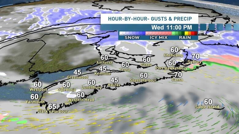
3 p.m. - 7 p.m. Messy commute home

For the Halifax metro region and most of mainland Nova Scotia, we should be seeing a mix from ice pellets to freezing rain and then drizzle during the commute home and supper hour. This will bring its own challenges for travellers. Expect to use lots of windshield washer fluid as temperatures near the freezing mark.
Winds will continue to gust 60-80 km/h.
Cape Breton will transition from snow to ice pellets during the commute home.
7 p.m. tomidnight Clean-up time
While Cape Breton continues to see ice pellets mixing in through the evening, the rest of mainland Nova Scotia will see generally dry conditions for shovelling and cleaning up the snow and ice of the day.
Temperatures will start the evening in the low to mid single digits, then fall back to freezing by midnight. A chance of drizzle will mix back to flurries as winds ease with gusts 50-60 km/h for most.
Thursday morning
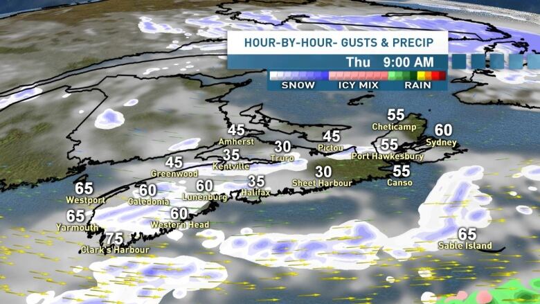
Some onshore flurries and snow squalls developing overnight Wednesday and through Thursday morning will bring another trace to a few cm locally. Northwest winds gusting 50-70 km/h will make for more blustery conditions for the Thursday drive to work, especially for the southwest, valley and central regions, including Halifax.
A chance of onshore flurries continues through the day on Thursday with winds staying breezy.
Another rainy warm-up
And finally a quick heads up that a system set to move in through Friday and Saturday is looking likely to bring another round of rain, gusty winds and mild temperatures.
More on that system in the coming days.
I'll have a full update on the system moving in and the long range forecast tonight at 6pm on CBC Nova Scotia News. See you then.
Follow the live blog
Keep up to date with our weather blog, updated every day.


_(720p).jpg)


 OFFICIAL HD MUSIC VIDEO.jpg)
.jpg)


