'Weather bomb' brings strong winds and rain Thursday
Strong fall storm will likely bring power outages and localized flooding to the Maritimes
A powerful fall storm is taking shape today over the northeastern U.S. and it has its sights set on the Maritimes for Thursday.
It will be our season's first "weather bomb," which is a rapidly developing storm that drops 24 or more millibars of centralpressure in 24 hours. This rapid strengtheningmakes the storm a bigger threat for strong winds.
The storm will track into southwestern Nova Scotia and New Brunswick with rain and strengthening winds early Thursday, and then spread northeastward across the rest of the region throughout the morning.
Thankfully, this storm is a quick mover. As you can see with the timeline below, the heaviest rain and strongest winds will blowthrough in six to eight hours.
Strong winds
The largest impact from this storm will be from the winds, and some power outages look likely.
In Nova Scotia, we're looking at widespread east-southeast gusts in the 70 to 90 km/h range, with gusts 90 to 110 km/h along the Atlantic coastline from Yarmouth to Cape Breton.
Gusts in excess of 110 km/h are certainly possible for exposed areas of the coast like Baccaro Point, Beaver Island and the usual spots in these types of events.Les Suetes winds will likely top 130 km/h.
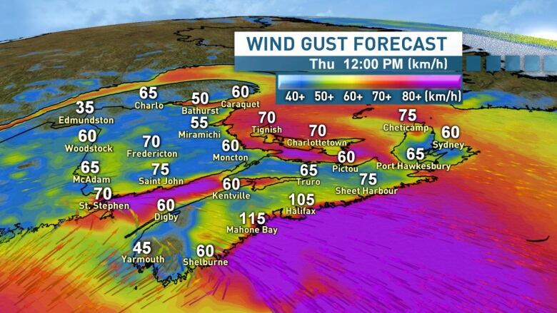
In New Brunswick, widespread gusts of 50 to 70 km/h are on tap, with gusts 70 to 90 km/h along the Bay of Fundy coastline and also from Moncton up the Northumberland Strait to the Acadian Peninsula and Bathurst region. Exposed coastal areas could certainly exceed 90 km/h.
Following those peak east and southeast winds, we'll see the winds subside and shift to southwest throughout the day.
High water levels
The storm will be tracking in around high tide for the Atlantic coastline of Nova Scotia. As a result, higher than normal water levels and pounding surf are likely, including in the Halifax region.

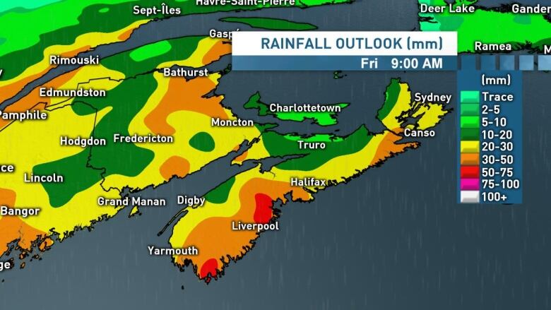
Heavy rainfall rates during downpours may cause some localized flash flooding, especially where wind-blown fallen leaves will be blocking storm drains.
We're looking generally at 10-30 mm across the region, with some pockets of 30-50 mm amounts, especially in southwest Nova Scotia. In the heaviest downpours we'll likely top 50 mm locally in some areas.
Stay tuned for updates on this storm. I'll be updating the live blog below with fresh details and expanded warnings later today. Of course I'll have the latest on CBC-TV at 6 p.m. this evening.
Follow the live blog
Keep up to date with our live weather blog, updated every day.


_(720p).jpg)


 OFFICIAL HD MUSIC VIDEO.jpg)
.jpg)


