First significant snowfall on the way for parts of Nova Scotia
Wintry week of weather continues with snow on the way for Thursday into Friday.
Winter doesn't officially begin for another few days, however we're getting an sneak preview across Nova Scotia this week.
The coldest temperatures so far this season are currently in place across the Atlantic region and this polar air mass will be in place right into Thursday.
That cold air will set the table for our first significant snowfall of the season across parts of the province on Thursday and Thursday night.
The incoming system will be tracking just south of the region, with Nova Scotia set to see snow along its northern edge.

The heaviest snowfall amounts are set for southwestern and central Nova Scotia where 15-25 cm is expected. Inland and higher terrain areas in the southwest could see 25-35 by Friday morning.
While the forecast models have become better aligned, there remains some uncertainty with the exact track. Any shift south or north will have an impact on totals and you should keep an eye out for updates into Thursday morning.
Timeline
This system will arrive with snow mid-Thursday morning in the Tri-County region, then move from west to east across the province through the day.

Halifax and central regions of Nova Scotia will see light snow arriving near lunchtime and the early afternoon hours. Moderate to heavy bands of snow are expected to move in throughout the later afternoon and evening hours and this will likely lead to a snowy and slow going commute home for many.
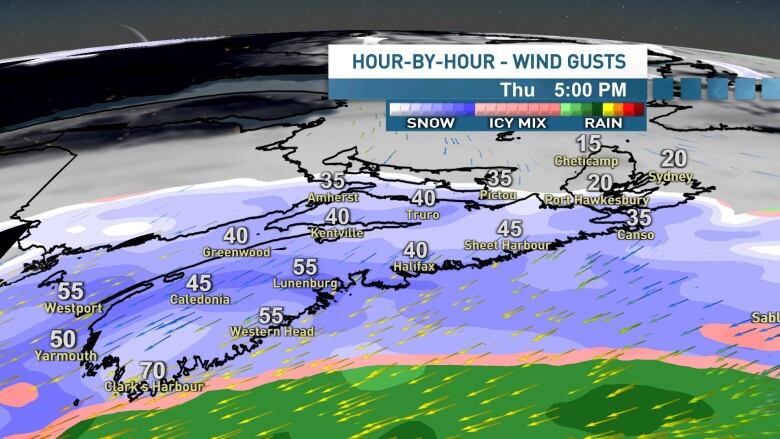
The snow will be fluffy to start this event and so while winds don't look overly strong, some blowing and drifting is likely for Thursday afternoon and evening time. Northeast windsare likely to gust 40-50 km/h for most, with some 60-70 km/h gusts possible along the South Shore.
We may see some brief mixing with ice pellets and drizzle along the South Shore during the late afternoon and evening as well.
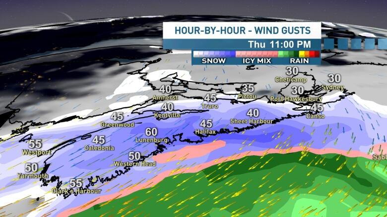
Moderate to heavy snow will continue overnight, before tapering off to light snow and flurries through the early morning hours of Friday.

A few lingering flurries are likely for the Friday morning commute and perhaps some light snow continuing for the Cape Breton region. Expect plenty of snow and slush on the roads.
AWhite Christmas?
For you snow lovers, my advice would be to enjoy it while it's here. Be sure to get out and take any festive season snapshots before the snow melts and washes away next week.
Forecast models are in good agreement that we'll see a return to warmer temperatures along with some showers for early next week and then perhaps again for Christmas Day itself.
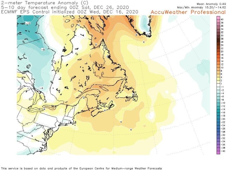
Despite the incoming snow, next week's warmth and rain will put a white Christmas in jeopardy.
As always, I will keep you posted. Stay tuned for updates on social media, radio and CBC Nova Scotia News at 6.
Follow the live blog
Keep up to date with our live weather blog, updated every day.


_(720p).jpg)


 OFFICIAL HD MUSIC VIDEO.jpg)
.jpg)


