Students sleuthing boundaries of mass grave of 1873 shipwreck victims
Study could help determine whether grave is at risk due to coastal erosion

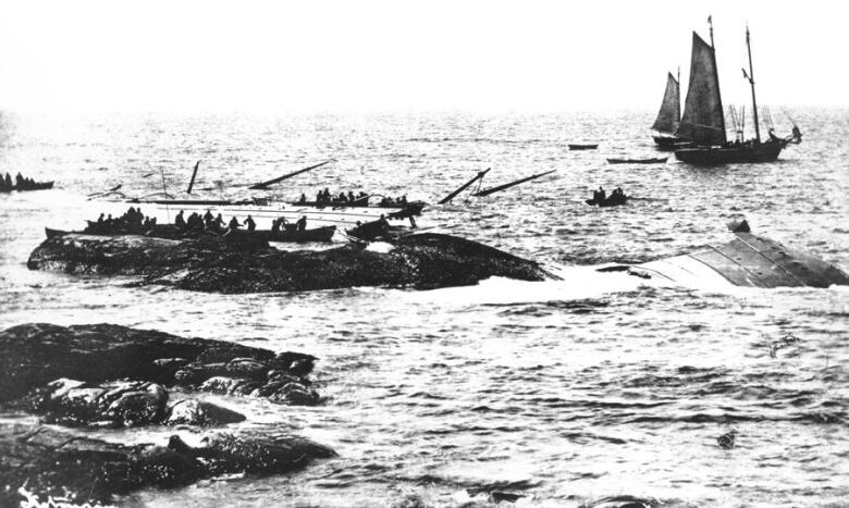
Hundreds drowned in their beds as the icy Atlantic flooded their rooms in an instant.
Some died dropping into the sea from the sinking ship, wearing nothing but their night clothes as a storm raged around them.
Many perished making a desperate attempt to reach the rocky coast of Nova Scotia in the early morning darkness of April 1, 1873.
The tragedy that struck the SS Atlantic has forever marked the communitiesnear Lower Prospect, N.S.
Two hundred and seventy-seven people were buried in a mass grave at St. Paul's Anglican Cemetery in Terence Bay, and another 150 were interred at the nearby Star of the Sea Roman Catholic Cemetery in Lower Prospect.
Now, a group of students from Saint Mary's University in Halifax is hoping to discover the exact boundaries of the mass grave in Terence Bay.
The students, led by archeology professor Jonathan Fowler, are using ground-penetrating radar and electromagnetic induction instruments to aid their effort.
John Corbett, chairman of the board of the SS Atlantic Heritage Park and Interpretation Centre, said the project was prompted in part by frequent questions from tourists about how so many people can be buried in such a small space.
"It seems to be a little smaller than simple math would suggest," Corbett said. "It's not important to the story, but it's one of those things there'ssort of a loose end that we want to tie off."
The ocean liner, which was carrying more than 950 people, was travelling from Liverpool, England, to New York when the captain, concerned there wasn't enough coal aboard to make it to thedestination, decided todetour to Halifax to refuel.
Butunbeknownst to the crew,a storm had pushed the ship off course, and at 3:15 a.m., travelling at full speed, it struck anunderwater shelf near what is now called Marrs Island, off Lower Prospect.

Within minutes, the giant vessel flooded and rolled onto its side. Lifeboats were destroyed or washed away.
As soon as local fishermen became aware of the disaster, they headed out in boats to rescue survivors. A rope strung between the SS Atlantic and a rocky outcroppingprovided a lifeline for those who were strong enough to make the journey, but huge waves and wintry waters claimed most who made the effort.
In total, at least 535 people died that fateful morning, including every woman on board and all but one child.Exact numbers of passengers and deceased are difficult to ascertain, due to inaccuracies in the passenger list.
Grave at risk from erosion?
Aside from simply figuring out the dimensions and exact location of the mass grave, the students' efforts could have another benefit.
In the 1990s, the integrity of the grave was threatened as storms and erosion wore away at the shoreline.
"Bodies were starting to become exposed by coastal erosion," Corbett said.
The coastline was shored up with boulders to minimize further erosion.
While Corbett said he hasn't heard of any similar problems recently, knowing the boundaries of the grave could help monitor whether the site could be threatened again.
"The recent storm Dorian cast a number of smaller rocks and whatnot that had been part of this rock wall back up onto the mass grave," he said.
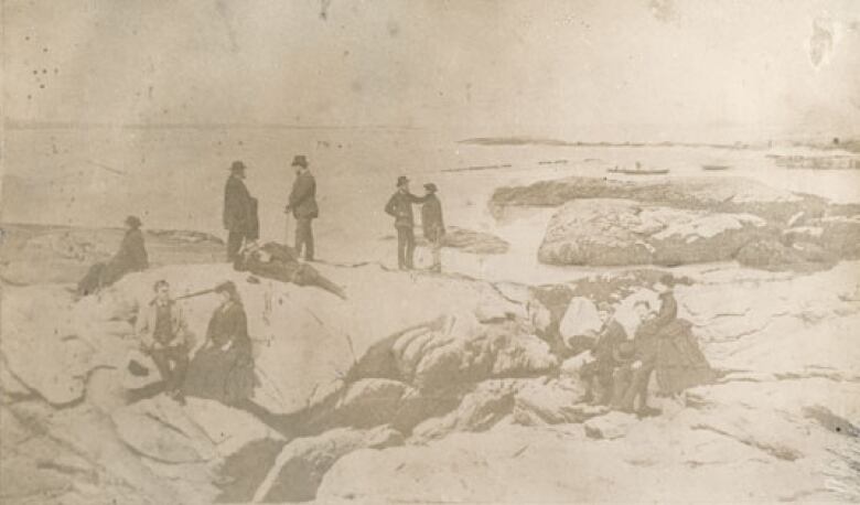
In addition to using technology to study the dimensions of the grave, the students have also turned to archival photos.
One photo, taken in the immediate aftermath of the tragedy, shows Rev. W.J. Ancient delivering a funeral service at the ocean's edge.

A row of wooden coffins liein a ditch in front of himas local fishermen and their families many of whom were likely involved in the rescue efforts and offered assistance to survivors gather around.
"It's an incredibly important image because not only does it capture the gravity of that moment, but it's one of the best sources we have to show us where the grave was," said Fowler.
Students are examining features in the photo, such as large rocks or outcroppings, to position themselves in relation to where the grave is pictured.
"It appears that the larger stones have not moved really at all," Fowler said.
"And so by lining them up, we can recreate a sense of where that photographer was standing. The students got a real charge out of it and they were all out there with their mobile phones and walking around looking at the image."
The group will also study aerial photos dating back to the 1950sto try to map how much of the shoreline has eroded and to understand future erosion possibilities.


_(720p).jpg)


 OFFICIAL HD MUSIC VIDEO.jpg)
.jpg)


