2019 floods: The latest road closures in Ottawa, Gatineau and beyond
Roads are likely to remain flooded through the week
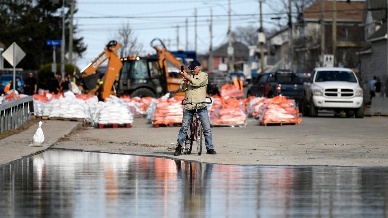
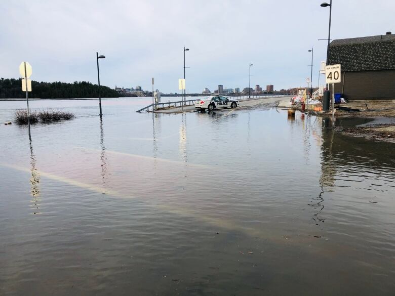
Rising waters have closed or reduced the capacity of several streets and highways in the Ottawa-Gatineau area.
Here's a list of some of the roads affected by flooding as of 7a.m. Sunday.
Officials are warning people to take care when driving through any standing or moving water as conditions can change rapidly.
Road closures in Ottawa
The Chaudire Bridge isclosed to all trafficuntil further notice.Traffic control devices are at the corner of Eddy and Laurier streets, and at the intersection of Booth Street and the Sir John A. Macdonald Parkway.
Route 44 and 105 buses will take the Portage Bridge.
Route 16 is avoiding Britannia Park and the Ron KolbusCentre, stopping on Britannia Road just to the east of the park instead.
- Willola Beach Road is closed due to flooding.
- Moorhead Drive is closed due to flooding.
- Ivy Acres Road is closed east ofRitchie Side Roads due to a collapsed culvert.
- Doris CurrieRoad is closed due to flooding.
- Trim Road is closed at Jeanne D'ArcBoulevard due to flooding.
- Grandview Road is closed at CarlingAvenue due to flooding.
- Greenland Road is closed from ArmitageAvenue to Rock Forest Road due to flooding.
- Len Purcell Drive eastbound closed from Whistler to Fireside roads.
- The northern end of Churchill Street N.is closed, north of Selby Avenue.
- Selby Avenue is closed from Churchill to Royal Avenue.
- BoisLane is closed.
- The northern end of Armstrong Road is closed, north of Phillip Road.
- Leo Lane is closed.
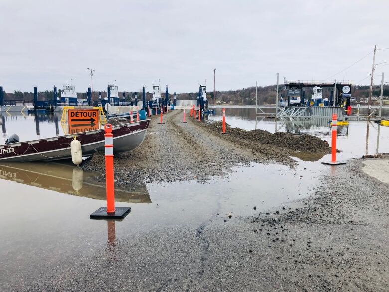
The Ecolos ferry between Rockland and Thurso and the Bourbonnais ferry between Masson-Angers and Cumberland are not running because of the flooding.
The Quyonferry was open early Monday morning, but was laterforced to suspend operations due to high water levels.
Road closures in Gatineau
The Quebec Ministry of Transportationis closing all the on and off-ramps from Highway 50 to rue Saint-Louis, with a detour along boulevard de la Gappe.
The Alonzo-WrightBridge between boulevard la Vrendrye and Highway 105 is dedicated to only westbound traffic from 5:30 to9:30 a.m. and eastbound traffic only from 3to 6:30 p.m.
The Boyes bridge is closed along boulevard Saint-RenEst between boulevard Lorrain and rue Boyes, meaningSaint-Renis restricted to local traffic only from Monte Dalton to Lorrain.
Pointe-Gatineau
- Rue Saint-Louis is closed between Boulevard de le Gappeand rue Moreau.
- Rue Moreauis closed from Saint-Louis to rue de Pointe-Gatineau.
- Boulevard de la Gappe south of rue Carmen.
- Rue Ren.
- Rue Blais.
- Rue Ernest-Charron.
- RueSaint-Franois-Xavier.
- Rue Oscar.
- Rue Adlard.
- Rue Corriveau.
- Rue Olida.
- Rue Oxford
- Rue Carmen.
- Ruelledu Como.
- Rue du Prince-Albert
- Rue Jacques-Cartieris closed from Saint-Louisto rueMontgolfires; another smaller stretch is closed further west from Saint-Louis to rue Joseph-Blanger.
Lac Beauchamp
- RueRiviera.
- Rue Saint-Saveur.
- Most of rue Campeau.
- Rue de Vimy.
- A section of rue Notre-Dame near Wabassee Creek.
- The southern end of rue Sanscartier.
- Rue Saint-Denis.
- Rue Glaude.
- RueSaint-Patrice.
- Rue Saint-Paul.
- Rue de Versailles and rue Sabourinbetween rue Watt and boulevard Hurtubise.
- Boulevard Hurtubise.
Masson-Angers
- Chemin du Fer--cheval.
- Rue Gabriel-Constantineau.
- Rue Victor-Charlebois.
- Rue du Ruisseau south of rue Lasalle.
- The southern end of chemin du Quai at the ferry terminal.
Aylmer
- Rue Lamoureux west of rue Dorion.
- Chemin Frasersouth of rue du Minervois and another section between rue Jacques-Philion and rue des Grand-Chateaux.
Roads in Gatineau restricted to local traffic only
- Rue Saint-Louis between rue de Picardie and boulevard de la Gappe, also between rue Rodolphe and rue Moreau.
- Saint-Renfrom Monte Dalton to boulevard Lorrain.
- Rue Jacques-Cartier between rue de la Baie to Montgolfires.
- RuesSaint-Patrice, Saint-Paul,Glaude and Saint-Denis between rue Saint-Andre andSaint-Sauveur.
- Rue Notre-Dame between rue Monseigneur-Lemieuxand rue Chamberland, and strips between boulevard Labrosse and rue de Vercheres.
- A section of rue Campeausouth of rue Notre-Dame.
- Rues Hemlock, Pine, Butternut and Saratogasouth of rue Juniper.
- Rues Forest andRen-Thriensouth of rue Arbutus.
- Rue Riverview south of Alle Higgerty.
- Chemin Queen's Park between rue de Corail and rue du Triathlon.
The city's flood page has an interactive map.
Road closures in eastern Ontario
Pembroke
- Albert and Alexanderstreets north ofLake Street as part of the city's efforts to keep people away from the waterfront.
- DorenStreet from Miller to McGee streets.
- McGee from Murray Street to Doren
- D'Arcy Street from Murray to Doren.
- Murray Street south of McGee.
Road closures in western Quebec
Pontiac:
- Chemin Anne.
- CheminBord de l'eau.
- Chemin Bronson-Bryantat Clarendon and 2nd Concession.
- Chemin Bruce.
- Chemin Cain.
- The end of chemin Dion.
- Chemin du Lac.
- Chemin Eardley-Marsh.
- Chemin Ferry.
- Chemin Gauvin.
- CheminGold Mine at 5th Concession.
- Chemin Mohr.
- Chemin Mulligan.
- Sections of cheminMurray.
- Chemin Proven between Beaudoin and 6th Concession.
- Chemin Rivire between cheminMulligan and Highway 148.
- Chemin Smith.
- As well, chemin Westbrook and cheminVielle Pompe are not closed, but are in bad shape and should be avoided.
Val-des-Monts:
- Chemin de la Montagneat chemin du Moulin.
- Rue de la Pineraieclosed at the culvert.
- Chemin Saint-Pierre at rue Dwyer,
- CheminTaylor.
- CheminWhipple at chemin de La Blanche.
- Chemin Brunke at the bridge.
- The northern end of chemin des Cavernes.
- Cemin de la Colline at chemin de l'Orme.
- Chemin de l'glise is closed to heavy vehicles.
- Chemin de Prtre.
- Chemin de la Truiteat the bridge.
Mont-Laurier:
- Rue Fortier between rue Achim and rue Laviolette. Open to localtraffic.
- Rue Achim.Open to localtraffic.
- Chemin de la Presqu'le.Open to localtraffic.
- Monte Lanthieron the western shore of Lac desles.Open to localtraffic.
- Chemin de Ferme-Rouge.Open to localtraffic.
- Chemin du Lac-de-la-Damepast the last house.
Saint-Andr-Avellin:
- The bridge over the Petite-Nation River on rue Principale, part of Highway 321,is closed.


_(720p).jpg)


 OFFICIAL HD MUSIC VIDEO.jpg)
.jpg)


