Ottawa River peaks, but could take weeks to return to normal
No significant rain, warmer weather forecast in next week
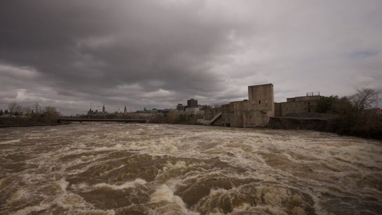
The historically high water levels along the Ottawa Riverpeaked Monday and are now expected to slowly recede, according to the group managing the river basin but it may be weeks before those levels return to seasonal norms.
The Ottawa River Regulation Secretariat forecast on Monday afternoon said that peak water levels occurredMonday at the Hull Marina in Gatineau, as well as in Thurso, Que. and Hawkesbury, Ont.
The South Nation ConservationAuthority confirmedTuesday that peak levels were reached along the Ottawa River from Mattawa to Hawkesbury.
The flood warning for the Mississippi Valley watershed, however, will remain in place until Friday, according to the Mississippi Valley Conservation Authority.
Levels on Dalhousie Lake appear to have stabilized and should start to decline Thursday, but there is some rain in the forecast for the weekend which could lead cause it them to rise again.
"Simply put, we have nowhere left to put any additional water," water management supervisor Gord Mountenay said in a news releaseTuesday.
Flows on the upper ClydeRiver peaked and have been dropping since yesterday. The lower part of the river peaked Monday night but had not started to decline as of Tuesday. Water levels on the Fall River have also stabilized, the authority confirmed.
The one exception is Mississippi Lake, where water levels are expected to climb another 10 to 20 centimetres before levelling off Friday, the authority said.
Levels at Britannia in Ottawa reached their high point Sunday, the Ottawa River Regulation Secretariatsaid.
In Quebec, Public Security Minister Martin Coiteuxsaid Tuesdaywater levels in the province have peaked and should begin to recede slowly. It will likely be the end of May before water levels are back to normal, he said.
The updates arewelcome news for areas hit hard by flooding, like Gatineau's Pointe-Gatineau neighbourhood and Ottawa's Constance Bay.
- When will the water subside? Residents, officials keep exhausted eyes on water
- Full coverage of the flooding in Ottawa-Gatineau
Warmer weather and a break from significant rain are helping to provide the timely relief, saidMichael Sarich, the senior water resources engineerwith the secretariat.
But water levels will continue to be high over the next couple of days before starting to drop, he added.
"We're going to be literally weeks with levels that are above normal. Probably it's going to be a week to 10days until we get down to even to what would be considered a high spring level," Sarich said.
Gatineauwater levels 3 metres above normal
The May mean water level for the Ottawa River at Britannia is about 58.78 metres above sea level. On Monday the water level was forecast to be about 60.45 metres, or 1.67 metres higher than normal.
Similarly, the mean water level in May at the Hull Marina in Gatineau is 42.18 metres; on Monday it was expected to peak at 45.18 metres, or about three metres higher than normal.
Sarich doesn't know exactly when water levels will recede enough for flooded neighbourhoods to return to normalcy, but said it won't take much of a drop in recently-hit areas before they noticea significant retreat from their homes.
"A lot of the questioning people have is how long is it going to take to go down. So our focus is going to change from forecasting when the peak is to the rate of recession," he said.
Rain showers possible, but not significant
The wild card, of course, is the rain.
After an April that had twice the normal rainfall and more rain in the first week of May than the normal average for the month, all eyes are on the weather forecast.
As of Monday evening, Environment Canada's forecast called for some flurries on Tuesday and then mostly sunny skies on Wednesday through Friday, followed bycloudy skies on the weekend and a chance of showers.
It's asimilar story in many surrounding regions that feed water into the Ottawa River basin.
Ian Black, CBC Ottawa's climatologist, said the rain that's expected is nothing significant.
"This is good news," he said.
David Phillips, the senior climatologist for Environment and Climate Change Canada, agrees.
"At first blush, if you look at the forecast, it looks more depressing," said Phillips. "But if you dig down deeper you are not dealing with major weather systems, so [there won't be] alot of accumulation."
Rainfall forecast murky after this week
Beyond that, the forecast becomes more difficult to predict, says Phillips.
Black and Phillips both say the temperature for the rest of the month is expected to be warmer, which will also help, but rainfall predictions are harder to pin down.
"Precipitation is a real crapshoot," said Phillips. "It's hard to get tomorrow and next day right, let alone next week."
Sarich said any length of time without significant rain in the region will help water levels drop and that'ssomething the region hasn't had in the past few weeks.
"[It was] one event after another, just one kind of building on another, not allowing the river system time to decrease," he said.


_(720p).jpg)


 OFFICIAL HD MUSIC VIDEO.jpg)
.jpg)


