U.S. National Hurricane Center projects Dorian to be Category 1 as it impacts eastern P.E.I.
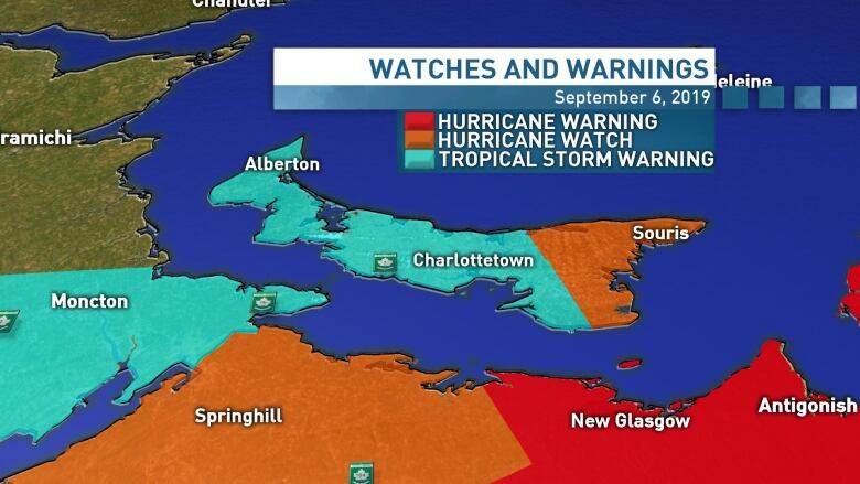
Eastern P.E.I. under a hurricane watch Prince, Queens under rainfall, tropical storm warnings
The latest projection for Dorian's arrival to Prince Edward Island has the storm as a Category 1 hurricane, according to the U.S.National Hurricane Center.
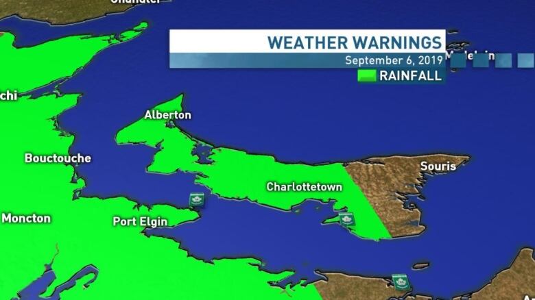
As Dorian draws closer to P.E.I., Environment Canada has issued rainfall andtropical storm warnings for western and central P.E.I.,and issued a hurricane watch for the eastern region.
The tropical storm warning for Prince and Queens counties meanssustained winds over 60 km/h are expected with gusts up to 100km/h possible, CBC meteorologist Jay Scotland says.
MAJOR UPDATE in Hurricane Dorian's official @NHC_Atlantic track. #Dorian is now projected to potentially impact Nova Scotia as a Category 2 hurricane and possibly move over or very near eastern P.E.I. as a category 1 hurricane. pic.twitter.com/9Y6BLu3spT
—@JayScotlandRainfall amounts of 40 to 60 millimetres are expected in those counties, the warning said, with higher amounts possible over the westernmost areas of the Island.
Depending on the track and intensity of Dorian, even stronger winds are possible over eastern P.E.I., Scotland said.
"This change in intensity in the official track is reflected by the hurricane watch in place over Kings County," he said.
Hurricane winds are sustained winds of 119km/h or more.
Scotland cautions that this is just a forecast and a transitionto a post-tropical storm before reaching P.E.I.is still possible.
"Whether it's officially a hurricane or a strong post-tropical storm, P.E.I. is still going to face strong winds and heavy rains regardless of the storm's category. Either way we're in for very wet and very windy conditions beginning late Saturday."
A storm surge warning is also in effect, andmeans higher than normal water levels are expected near the shore.
"The intense winds associated with Dorian are forecast to generate large waves and storm surge for parts of the Gulf of St. Lawrence," the warning said."Storm surge is most likely to be a concern Saturday evening and overnight."
HURRICANE WATCH for Kings and TROPICAL STORM WARNING for Prince/Queens. I see potential of 60+ km/h sustained wind for central/west P.E.I. with 100+ km/h gusts possible. @ECCC_CHC sees "slight possibility" of "near-hurricane conditions" over Kings County during passage of #Dorian pic.twitter.com/LoQBU5FTnW
—@JayScotlandScotland said coastal areas may be impacted by strong winds during Dorian'spassage Saturday evening and overnight.
Elevated water levels combined with high waves and a potential storm surge may result in some coastal flooding and erosion, Scotland said.
"My main concerns arepower outages and local flooding.With high waves and a potential storm surge, some coastal flooding is possible in addition to inland flooding due to the high volume of rain falling over a matter of hours," he said.
"We haven't experienced a lot of high winds over the summer so there is potentially a lot of dead or dying branches that may be brought down by Dorian's strong winds.
"With saturated soil, there's also the potential for downed trees. So please be prepared to lose power."
Some cancellations already
Doug Newson, CEO of the Charlottetown Airport, advised passengers to check their flight status before coming to the airport. Air Canada and WestJet have issued travel advisories in connection with the storm.
Newson said Air Canada has already cancelled the twoovernight flights for Saturdaynight and Sunday morning to Montreal and Toronto, as well as some evening flights between Halifax and Charlottetown on Saturday.
If you are booked to travel Saturday or Sunday out of an airport in the Maritimes call your airline for options regarding changing your flight.
Northumberland Ferries has cancelled all scheduled sailings between P.E.I. and Nova Scotia on Saturday.On Sunday, crossings are expected to start in the afternoon. The company warned customers to expect service disruptions on Sunday.
Emergency officials are advising Islanders to tie down or move inside anything that could be picked up by the wind. Islanders should also be prepared for power outages, which are more likely in strong winds with the leaves still on the trees, by putting together 72-hour emergency kits.
More P.E.I. news
With files from Jay Scotland


_(720p).jpg)


 OFFICIAL HD MUSIC VIDEO.jpg)
.jpg)


