Winter storm to bring full mix of weather to Maritimes
A little something for everyone in coming Eastern Canada storm
A storm passing over the Maritimes tonight and into tomorrow is expected to bring something different for just about everyone, depending on where you live.
CBC meteorologist Peter Coade said anywhere there is snow coming down, there will be a chance of some difficult conditions.
"We're going to have snow, mixed with ice pellets in the afternoon, and if you've got ice pellets around, there's always the risk of some freezing rain," Coade said.
"With that wind, and that snow, and the temperature around zero, you are going to have some areas of local blowing snow. It's not going to be widespread, but there will be some isolated areas of near zero visibilities."
Mixed bag for N.B.
As usual,northern New Brunswick will see most of the snow.
Environment Canada has issued weather alerts for most of the province, running the gamut from snowfall and rainfall warnings, to freezing rain and winter storm warnings.
The northern part of the province could see as much as 25 centimetres of snow. The Fredericton area is bracing for ice pellets and ice buildup due to freezing rain. The Saint John area will be spared heavy snowfall, as the precipitation is expected to fall mainly as rain. Environment Canada warns a total of 40 millimetres of rain is expected to fall, with a risk of flash floods and localized flooding.
'Wintry mix of precipitation' for N.S.
Nova Scotia is expected to get off lightlyin the snow department. In Halifax, Environment Canada is calling for a "wintry mix of precipitation" starting with ice pellets before turning mostly to rain.
In northern Nova Scotia, precipitation will start as snow early Tuesday, before changing to ice pellets and freezing rain during the day, then tapering to showers or flurries in the evening.
The Cape Breton area could see up to 15 centimetresof snow, while the Atlantic coast region could see up to 10 millimetresof rain.
Snow, ice pellets on P.E.I.
The western part of Prince Edward Island is expected to get as much as 25 centimetres of snow, starting late Monday and becoming heavy at times into Tuesday morning.
The snow will likely mix with ice pellets through the afternoon, before turning into flurries or showers Tuesday evening.
"Prepare for quickly changing and deteriorating travel conditions," Environment Canada warns. "Rapidly accumulating snow could make travel difficult over some locations."
The rest of the Island is expected to see about 15 centimetres of snow, starting with a steady snowfall Tuesday morning, changing to ice pellets in the afternoon. The snow will taper to flurries or showers near midnight.
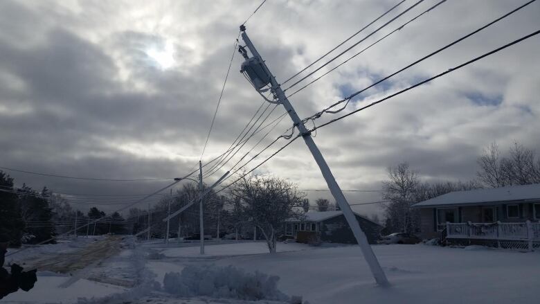
Islanders hopethis storm, which will likely produce wet snow with temperatures around the freezing mark, will not produce a repeat ofDec. 3, when a storm dropped 24 centimetres of heavy snow that took down power lines across the province. Tens of thousands lost electricity, and some were out for days.
Find out what's open and closed in your region, and follow our live coverage of the storm:


_(720p).jpg)


 OFFICIAL HD MUSIC VIDEO.jpg)
.jpg)


