Despite frequent storms, Sask. tornado count on par with average
Last couple of years had been quieter because of heat, forest fire smoke
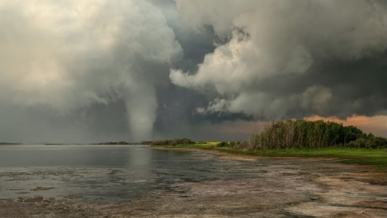
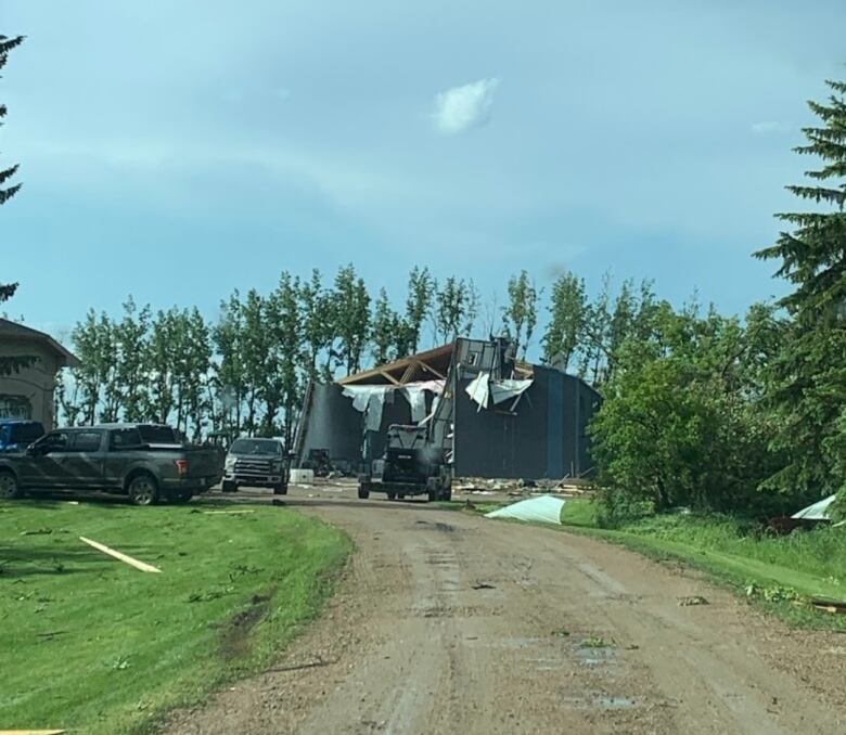
Saskatchewan has recorded 15tornado touchdowns so far in 2022.
Eleven of those have been in just the past two weeks.
But Environment and Climate Change Canada (ECCC) meteorologist Terri Lang says this is what Saskatchewanshould expect at this time of year.
According to ECCC, Saskatchewan records an average of about 17 tornadoes in a calendar year.
"That can [range]as high as the high 30sand as low as two," said Lang. "To me, this is more like the summers that we're used to."
Last summer, dry, hot weather coupled with forest fire smokeprevented storms from developing for much of the season. In July 2021, the province didn't record any tornadoes something that hadn't happened since 1959.
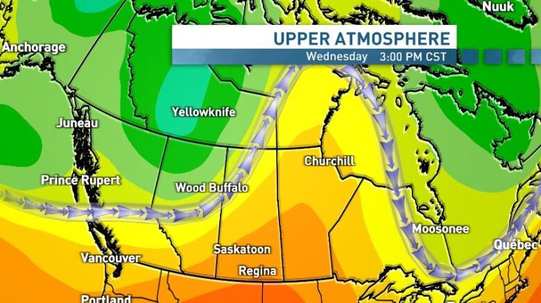
This year, Lang attributes an "open trough" pattern in the upper atmosphereand the positioning of the jet stream over the provincefor the frequent storms. As things like low pressure systemsor theirassociated frontal boundaries interact withthe trough and jet stream,they act as a trigger for unsettled weather.
Additional humidity from above average moisture falling through the spring and evaporationfrom growing crops has also played a key role in storm production.
"It really does makea difference in the amount of storms that we can have," said Lang.
"It ... kind of feeds back on itself. If you get more storms, you get more moisture which allows more storms to kind of keep going."
Intense heat heraldsweather pattern change
While severe weather is possibleagain in the afternoon and evening hours Wednesday, a multi-day event is unlikely because of a change in the jet stream.
A ridge of high pressure will bring intense heat, with highs into the low to mid 30s, and overnight lows staying above 15 C for much of south and central Saskatchewan for the next week or so.
A quick break from the heat is expected Thursday and Friday, before the ridge re-intensifies over the weekend, with humidex values getting close to 40 in some places.
The City of Saskatoon has activated its extreme heat response plan, which will ensure cooling locations, wellness checks and water distribution to people who are experiencing homelessness, according to a release from the city.
In Regina, the Salvation Army is making similar preparations at its Waterston Centre shelter, according to Al Hoeft, a public relations officer for the organization.
"In the downtown core we want to make sure that there are places where folks ... are able to find a place where they can cool down, stay safe and get some water and potentially other services as well," said Hoeft.
He said people can come and go from the centreas well as other places like the Central Library, Newo Yotina Friendship Centre or Carmichael Outreach as needed during thisperiod of heat.
"It's really important during these extreme heat events ... that we're making sure people have safe places to go," said Hoeft.


_(720p).jpg)


 OFFICIAL HD MUSIC VIDEO.jpg)
.jpg)


