Technology increases odds of finding Franklin ships
This summer's search in the Canadian Arctic for the lost ships of Sir John Franklin's 1845 expedition will deploy a host of technologies, some tried and true and some new.
The six-week search, a co-ordinated effort involving several federal agencies as well as the University of Victoria, will converge on two areas west of King William Island in Victoria Strait in early August.
The headquarters for Franklin search operations will be the Martin Bergmann, a 19-metre research vessel, and the Sir Wilfrid Laurier, an 83-metre Canadian Coast Guard icebreaker.
Alison Proctor, a research engineer with the University of Victoria, will use a new autonomous underwater vehiclethe Bluefin 12 AUVfor the first time this summer in the search for the Franklin ships.
Not available in time for last summer's quest for HMS Erebus and HMS Terror, the "no strings attached" technology should be a valuable new tool in this year's arsenal of search technology, Proctor says.
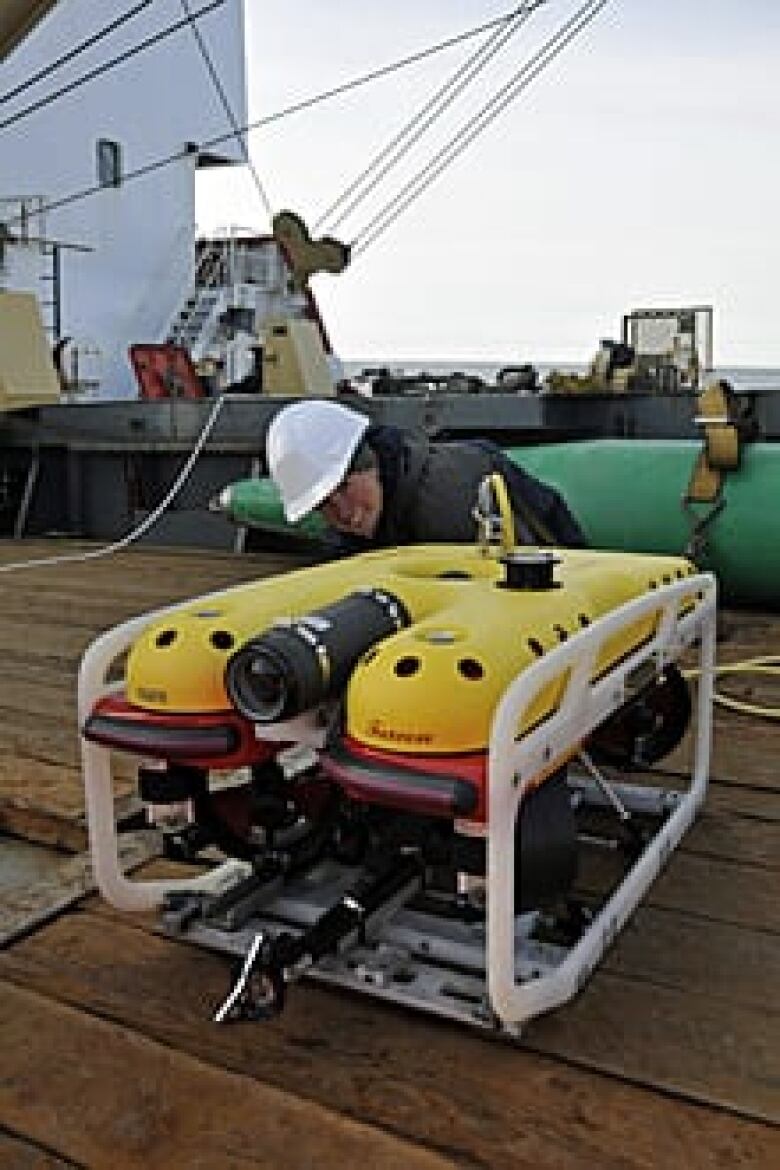
However, it is not a small instrument. With a length of 3.5 metres, and weighing in at 204 kilograms, the torpedo-shaped device, equipped with several onboard computers, has to be carefully hoisted over the ship's side and into the ocean, Proctor says.
Then the $800,000, remote-controlled device is on its own.The AUVs "side-scan" technology consists of two sonar transducers on the sides of the "torpedo" directed at a 20-degree angle toward the sea floor, allowing a wide swath of data collection into its computers.
"We command it to do a mission from the surface, so it goes off, completes its work, and then comes back to us," Proctor says.
Computer control
She or another member of her four-person team will control the AUV using a laptop computer while sitting in a 16-foot tender boat from the Martin Bergmann.
"Once it's back, we download and analyze the image data. It will collect acoustic imagery from the sea floor that will allow the Parks Canada team to look for artifacts related to the Franklin search."
Proctor expects that she and her team from the University of Victoria will deploy the device about 12 hours a day during the six-week search for the Franklin ships.
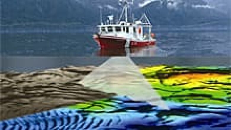
In 2008, Parks Canada initiated a partnership with the Canadian Hydrographic Service to conduct a joint survey to scan the sea floor and to determine underwater depths and topography, as well as try to find the Franklin shipwrecks.
Ryan Harris, a marine archeologist with Parks Canada, will be directing sea floor scanning for the Franklin ships with newly acquired "multibeam" echo sounders.
The sonar beam-emitting boxes will send out fan-shaped audio pulses thousands of acoustic beamsto the sea floor from the Canadian Hydrographic Service launches Gannet and Kinglet.
"The sounders give individual depths in a big line perpendicular to the path of the launch, so that paints the sea floor in terms of the depths," Harris says.
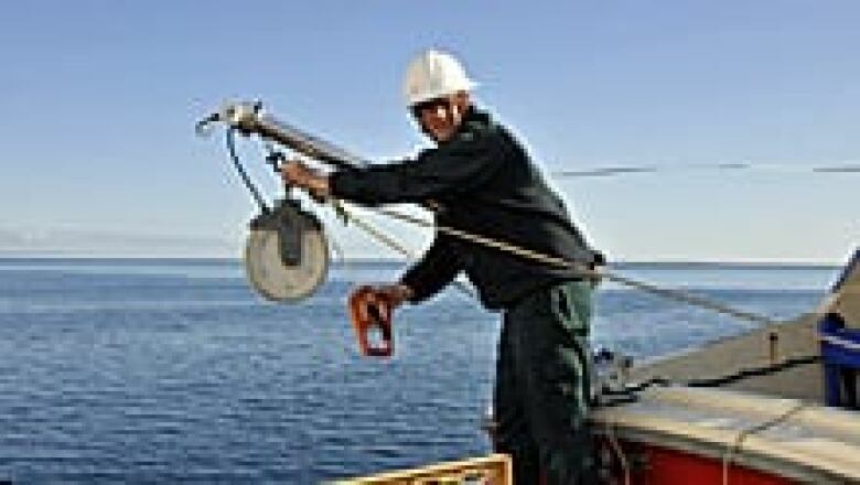
At the same time, each launch will pull a sonar towfish attached to a tow cable on a winch.A third sonar towfish will be pulled by the Martin Bergman.
Towfish are a commonly used technology to gather hydrographic data. Each towfish, a 1.2-metre, stainless steel cylinder with two side-scantransducers and rear fins, "flies just above the sea floor, and scans about a 100 metres out to each side, and at very high resolution shows rocks and other features, such as shipwrecks, on the ocean floor," says Harris.
The surface operator has a "real time look at the acoustic data," Harris says.If something of interest is detected, the operator can direct the towfish to the area where it was recorded to take another look, often at a higher resolution.
But Harris adds that there is a downside to the towfish technology. The rougher the ocean, the bouncier the ride of the towfish, and the more difficulty in analyzing what the towfish is "seeing" below.
Surveying the ocean floor
The Canadian Hydrographic Service's interest in the Franklin ship search area goes well beyond finding the Terror and Erebus.
The Franklin search site, says George Schlagintweit, operations manager for the service, is an area of increasing vessel traffic through the Northwest Passage, but the lack of survey detail limits the amount of marine traffic able to safely ply the waters.
To enhance navigational data and aid in the search, the Hydrographic Service is deploying technology from the air.
Called LiDAR (or light detection and ranging), it uses light pulses that are emitted into the ocean from a unit installed on a Beechcraft airplane. Its a technology that has been deployed previously.
"It does much the same as what acoustic depth-measuring technology provides," Schlagintweit says.
"It gives you a representation of the seabed with its depths from light data bouncing back to the aircraft. LiDAR uses light to measure depths, and acoustics uses sound.We end up with an image of what the seabed looks like if there were no water on it."
From the data, the hydrographic service is able to produce detailed nautical charts. Ice cover and water cloudiness reduce depth measurement capabilities by LiDAR, but with good conditions, using this aircraft technology is a much faster way of gathering mapping data, Schlagintweit says.
The up-to-date technologies "are quite exciting," he says. "We're seeing the ocean floor like we've never seen it before."
Other agencies involved in hydrographic surveying in the Arctic include the Canadian Space Agency, which provides satellite imagery, as well as the Canadian Ice Service.
The ice service provides ice data for day-to-day search operations this summer, as well as historical ice and climate data that could help narrow down the target area for the search.
Schlagintweit says the overall goals of the collaborations and technologies are to improve navigational safety, produce more detailed charts and evaluate the remote sensing technologies
"One of the goals overarching for this project," says Schlagintweit, "is to assist Parks Canada in their quest to locate the Franklin expedition vessels. They are symbols of national pride to the British and to the Canadian public at large.
"If they're sitting there on the ocean floor, and we get over top of them with our multibeam sounder, we will see them.
"We really have some amazing technologies we can use to assist us. If there's ever a time to find those vessels, now is it."


_(720p).jpg)


 OFFICIAL HD MUSIC VIDEO.jpg)
.jpg)


