Air quality statements issued as over 140 forest fires burn in northwestern Ontario
Fire hazard high to extreme in Kenora, Dryden, Fort Frances, Thunder Bay, Red Lake districts
Environment Canada has again issued air quality statements for much of the northwestern Ontario due to smoke from the more than 140 forest fires in the region Tuesday.
The statementsare in effect for the Dryden, Ignace, Fort Frances, Rainy Lake, Geraldton, Manitouwadge, Hornepayne, Kenora, Lake Nipigon, Nipigon, Marathon, Pickle Lake, Red Lake, Ear Falls, Pikangikumand Sioux Lookout areas.
"Smoke plumes from active fires in northwestern Ontario and eastern Manitoba will continue, resulting in poor air quality," Environment Canada said. "Low visibilities can also be expected, particularly in areas closer to the fires."
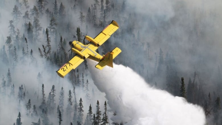
Aviation, Forest Fire and Emergency Services (AFFES) said 18 new fires had been discovered in the region by Monday evening.
Breakdown of larger fires
Firefighters continue suppression efforts on a number of large, established fires in the region, including:
-
Red Lake 65, about 17,500 hectares and burning six kilometres northwestof Poplar Hill First Nation. AFFES said the eastern edge of the fire is being monitored, and an ignition plan has been been approved andwill be implemented when conditions are safe. Poplar Hill has been evacuated.
- Red Lake 51, about 51,900 hectares and24 kilometres west ofDeer Lake First Nation. The community has been evacuated. AFFES said crews are focused on protection of community infrastructure.
- Sioux Lookout 60, burning about eight kilometres west ofCat lake First Nation. Apartial evacuation of the community has taken place. Crews are establishing hose lines on the fire, AFFES said.
- Red Lake 77, about 23,400 hectares, and 33 kilometres west of Red Lake. AFFES said crews are working to build 40 kilometres of fire guard in strategic areas.
- Kenora 51, about 156,300 hectares, burning inside Woodland Caribou Provincial Park. The fire is not under control.
A restricted fire zone remains in effectin the Kenora, Fort Frances, Dryden and Thunder Bay districts, and portions of the Sioux Lookout, Red Lakeand Nipigon districts. Outdoor burning is prohibited in those areas.
The province previously issued an emergency order for northwestern Ontario, whichallows itto take special measures"to ensure the safety of people and the protection of critical property."
The restrictions apply to certain industrial operations that have the potential to cause sparksand start fires. A complete list of affected operations isavailable on Ontario's forest fire information page.


_(720p).jpg)


 OFFICIAL HD MUSIC VIDEO.jpg)
.jpg)


