These are the 5 things forecasters are most worried about with Hurricane Florence
From blocking patterns to storm surge, several factors could make this system one to remember
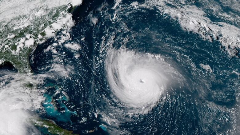
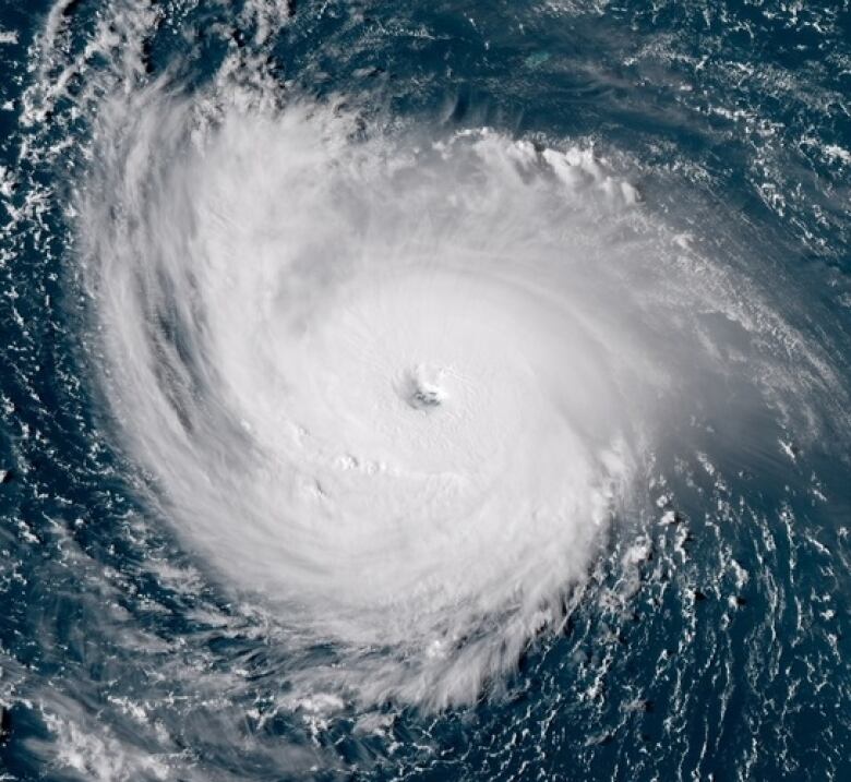
Hurricane Florence,a powerful Category 4 hurricane poised to strengthen over the next 24 hours, is expected to make landfall somewhere between North and South Carolina by late Thursday.
As with any hurricane, Florencewill be adangerous storm. But weather forecasters are particularly concerned about Florence due toa handful of factors.
Here's why.
Slow-moving storm
Hurricane Florence was producing maximum winds of 225km/h, and moving at 28km/h, as of 2 a.m. ET Wednesday. But once the storm systemreaches land, its speedis expected to drop to as slow as 5.5 km/hto 9 km/h.
"It looks like as soon as it gets to the coast, there's a good chance it's going to stall right out.So [it will] end up getting cut off from the main jet stream flow that normally carries systems quickly up the coast," said CBCmeteorologist Johanna Wagstaffe. "Instead, it'll just sit and spin."
Part of the reason is that a blocking patternwhere high- and low-pressure systems stay in place is expected to preventthe weather systemfrom quickly moving on, which could lead to prolonged danger for the region.
Flash flooding
The U.S. National Hurricane Center(NHC)is warning residents across the Carolinas and other mid-Atlantic states that "catastrophic" flash floodingand "significant" river floodingis possible, with38 to 63 centimetres of rainfall expected from Florence.
Again, that's partly due to the nature of the slow-moving storm.But itis exacerbated by the fact that, earlier thissummer, blocking patterns also forced prolonged rains in parts of the Carolinas.
With the ground already saturated and unable to absorb extra moisture, there's nowhere else the watercan go but upwardand further inland.
Storm surge
No matter the intensity, a hurricane disrupts a large amount of water in the ocean.
If the hurricane remains at sea, the storm surge it produces is minimal. But once the hurricanereaches thecoastline, the storm encounters shallower water, and the displaced water has nowhere else to go but forward.
"Storm surge is always a concern with hurricanes," said Wagstaffe. "Basically, it's the forward motion of the hurricane combined with winds that are wrapping around sort of counterclockwise.So on the right-hand side of the storm, you get the addition of the forward speedplus the winds and that's literally pushing the water ahead of it.
"Andall of that water piles up as it moves into shallower coastlines."
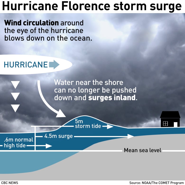
The continental shelf the portion of the continent's crust that is underwater around the Carolinas is particularly shallow, which could createa higher surge.
As an addedpunch,one of the things meteorologists are keeping an eye on is high tide, Wagstaffesaid, which is expected late Thursday into Friday exactly around the time when Florence is expected to make landfall.
This could add another metre or more of surge, which is forecast to be as high as four metres in some parts of North Carolina.
Hurricane-force winds
It likely goes without saying that hurricanes produce punishing, potentially deadly winds.
"Because [Florence is]such a large storm, as well as such an intense storm, by tomorrow afternoon, the coastline will probably start to feel tropical storm-force winds. That radius extends out much farther than hurricane-force winds do," Wagstaffe said.
By tomorrow afternoon, she said, the region may already start to see damage.
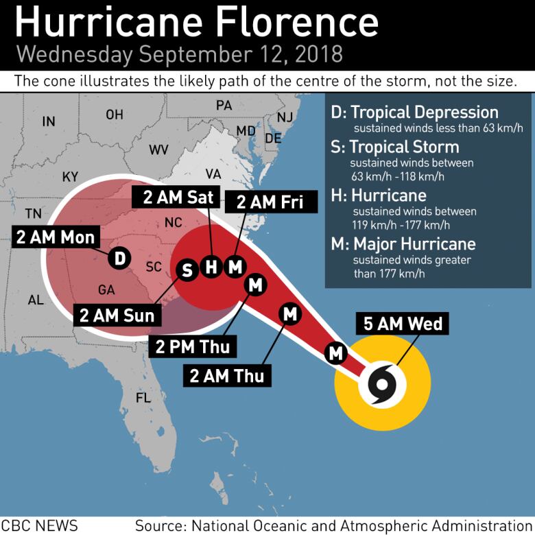
Florence's tropical storm-force winds extend 275 kilometresfrom the storm'scentre, but its hurricane-force winds extend 95 kilometresfrom its centre.
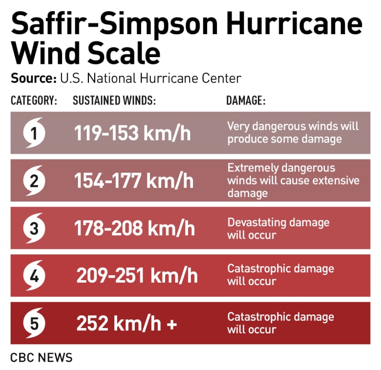
"The closer to the centre, the closer to feeling Category 4, which is catastrophic," Wagstaffe said.
Hurricane Florence weakened slightly as it underwentsomething called an eyewall replacement cycle, which occurs when a new eyewallforms,eventually breakingdown and replacingthe old one.
Once that process is complete, the stormregains its strength.
The National Hurricane Center is forecasting that Florence could produce sustained winds of 241km/hover the next 24 hoursjust shy of the 252km/h threshold that would push it toCategory 5 strength.
Surf and riptide
Hurricanes also affect rip currents the narrow currents of water thatflowoutward from a beach or a coast and these effects are felt much earlier than otherimpacts from such storms.
It may be a sunny, blue-sky day, with a hurricane still tracking days away,but in the lead-up to the storm, rip currents can still strengthenand pull people out to sea.
Florence has already demonstrated such power. Over the weekend, authorities undertookmore thantwo dozen rescuesat Wrightsville Beach in North Carolina.
Will Florence be felt in Canada?
On Monday, parts of southwestern Ontario were wet and gloomy, as remnants from Tropical Storm Gordon moved in. The same system drenched the Maritimes on Tuesday.
Though it's still considered a long-term forecast, the lower Great Lakes might seea similar setup once the blocking pattern that will keep Florence from movinglifts earlier next week.But it's uncertain how much rain moisture may remain.


_(720p).jpg)


 OFFICIAL HD MUSIC VIDEO.jpg)
.jpg)


