Hurricane Otis turned into a monster overnight. Forecasters don't know why
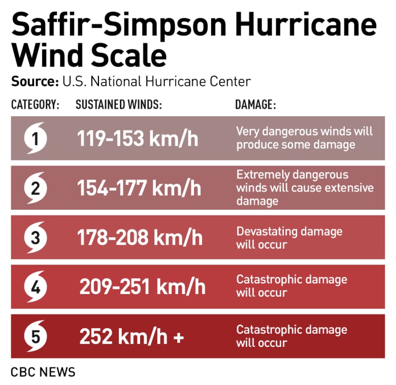
Went from tropical storm to a Category 5 hurricane in just 24 hours
The normally bustling beach resort town of Acapulco, Mexico, looks like a scene out of a disaster movie: palm trees stripped of its fronds; windows of hotels and homes shattered; twisted metal signs strewn across streets. All wreckage wrought after Category 5 Hurricane Otis slammed into the region on Wednesday just after midnight local time.
In the end, 27 people lost their lives.
The hurricane took everyone by surprise, including forecasters. The lingering question of why remains.
Otis began as a tropical depression (as all hurricanes do) on Sunday afternoon before transitioning into a tropical storm hours later.
The U.S. National Hurricane Center (NHC), a world leader in tropical storm forecasting, was closely monitoring it.
By Monday evening, it forecast tropical storm conditions and "possible" hurricane conditions beginning late Tuesday.

But that's not what happened.
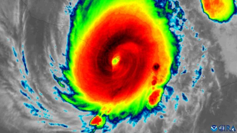
Instead Otis went from winds of 100 km/h to 268 km/h in 24 hours from Tuesday to Wednesday. By Wednesday evening, the NHC called it a "nightmare scenario."
This type of strengthening is referred to as "rapid intensification." While these types of hurricanes are becoming more common, it was Otis's magnitude that was so shocking.
Imagine starting your day expecting a stiff breeze and some rain, and overnight you get catastrophic 165 mph winds. Acapulco has never experienced a storm anything remotely like this-- never even a Category 2 hurricane. [2/2] pic.twitter.com/AiYAkzljY3
—@BMcNoldyTo put it into perspective, the NHC defines rapid intensification as storm winds that increaseby55 km/h in a 24-hour period. Otis more than doubled that.
"We were expecting maybe it could be a strong tropical storm or hurricane. Some of the models were kind of getting to that, but even when it started to intensify as much as it did, I was kind of thinking maybe it would peak out at a Cat 3," said Andy Hazelton, an assistant scientist at the University of Miami's Cooperative Institute for Marine & Atmospheric Studies who specializes in hurricanes.
"But it just kept going all the way up to landfall, which is sort of a worst-case scenario, especially when you're in that populated of an area."
'Very surprising'
Weather forecasters don't rely on just one model, but look at many different ones. The problem with Hurricane Otis was that not one model predicted this rapid intensification, especially to that degree.
So the question is: Why not?
"That's the question that we're still trying to untangle," Hazelton said."And we'll probably be trying to untangle for a while a little while in terms of with research.
"Models have gotten a lot better over the last decade or two, if you look at the stats ... certainly in the last 10 years, even sometimes with rapid identification. So to have a miss like this is very surprising."
Warm ocean water serves as the fuel for tropical storms. And while there was some deep warm water, Hazelton said, models take that into account.
Updated to account for Otis having explosively intensified from a tropical storm to a category 5 hurricane in less than 24 hours: pic.twitter.com/Bvurpo9LFl
—@burgwxHe also notedthat small storms can make it harder to forecast which Otis was initially and there was a wind pattern that contributed to strengthening, which could have also contributed to the inaccuracy of the predictions. But once again, models in the past have also been able to take that into account and forecast accurately.
One main factor may have been the initial forecast. Hazelton says forecasters look at the atmosphereand then models do the equations that forecast a day to a week ahead.
"Part of getting good models is getting those equations right, but you also have to have a good initial state of the atmosphere. So, you know, they say'garbage in, garbage out' if your initial state is really bad, and doesn't accurately capture what the storm was likeinitially, then,even with good physics and a good map and the model, you're going to have that [incorrect] forecast."
Climate and/or El Nio
While Earth's oceans are the warmest they've been in recorded history, it's not entirely clear if the fingerprint of climate change is on Hurricane Otis.
"It's always hard to pin specific events to climate change," Hazelton said."There are studies that attempt to do that. I'm sure that will be done on this one."
There have been recent studies about rapid intensification, with more of a focus on the Atlantic Ocean, but teasing out the human-caused contribution is more difficult when it comes to hurricanes.

"It's more difficult to tease out a global greenhouse gas inducedsignal change in hurricane activity than something like global mean temperature or sea level rise," said Tom Knutson, a senior scientist with the National Oceanic and Atmospheric Administration's Geophysical Fluid Dynamics Laboratory "We just don't have records [as long]."
A recent study found that there has been a "significant increase" in rapid intensification eventsoccurring 400 kilometresoff coastlines, tripling from 1980 to 2020, which could continue as our planet warms.
And Otis isn't the first storm we've seen undergo rapid intensification this hurricane season. In August, Hurricane Idaliawent from a Category 1to a Category 4 storm in within24 hours.
Another factor that may have contributed to Hurricane Otis is El Nio thenaturally occurring pattern of warming of the ocean surfacewhich is occurring in the Pacific Ocean at the moment.
"El Nio probably did play somewhat of a role in thatit tends to make the eastern Pacific warmer, and more favourable if you have more rising motion there," Hazelton said.
Scientists may have been caught off guard by Otis, but there are sure to be studies to follow.
"Anytime it's not wellforecastlike this it kind ofgives us pause because like,what are we missing in the models?" Knutson said.
"From a scientific perspective, it gives us an opportunity to learn and do better. But certainly, it reminds us how far we have to go."


_(720p).jpg)


 OFFICIAL HD MUSIC VIDEO.jpg)
.jpg)


