The Arctic just had its warmest winter on record
Reduced Arctic sea ice may be driving freak snowstorms in Europe, violent storms in North America
Winter at the top of the world wimped out this year.
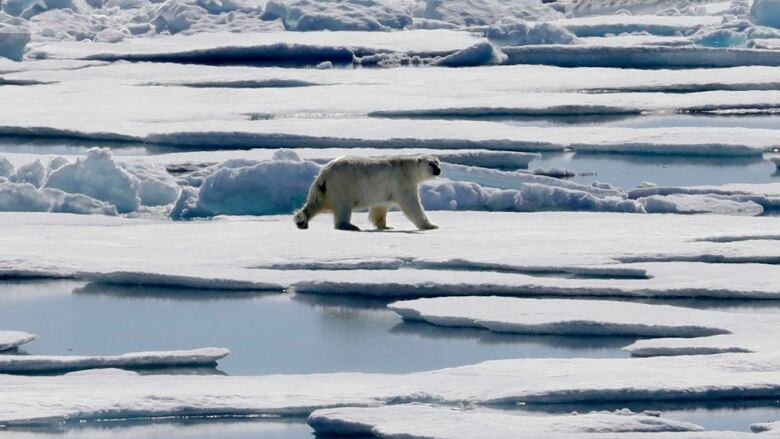
The Arctic just finished its warmest winter on record. And sea ice hit record lows for this time of year, with plenty of open water where ocean water normally freezes into thick sheets of ice, new U.S. weather data show.
Meteorologists consider December, January and February to be winter, and Arctic weather stations averaged 4.9 degrees Celsius (8.8 degrees F) warmer than normal for the season that just ended. The air above the Chukchi and Bering seasnear Alaska averaged about 11 degrees Celsius (20 degrees F) warmer than normal for February, theU.S. National Snow and Ice DataCenterin Boulder, Colorado,reported.
Scientists say what's happening is unprecedented, part of a global warming-driven vicious cycle that likely plays a role in strong, icy storms in Europe and the U.S. Northeast and Eastern Canada.
These heat waves, I've never seen anything like this.- Mark Serreze, U.S. National Snow and Ice Data Center
"It's just crazy, crazy stuff," said Mark Serreze, director of the National Snow and Ice DataCenter, who has been studying the Arctic since 1982. "These heat waves, I've never seen anything like this."
It's been so unusually warm that the land weather station closest to the North Pole at the tip of Greenland spent more than 60 hours above freezing in February. Before this year, scientists had seen the temperature there rise above freezing in February only twice before, and only ever so briefly. Last month's record-hot temperatures at Cape Morris Jesup have been more like those in May, said Ruth Mottram, a climate scientist at the Danish Meteorological Institute.
But it's more than that one place. Across the Arctic Circle in Barrow, Alaska, February was 10 degrees Celsius (18 degrees F) warmer than normal and the entire winter averaged 7.8 degrees Celsius (14 degrees F) above normal. Of nearly three dozen different Arctic weather stations, 15 of them were at least 5.6 degrees Celsius (10 degrees F) above normal for the winter, according to data from climatologist Brian Brettschneider of the International Arctic Research Center at the University of Alaska Fairbanks.
"The extended warmth really has kind of staggered all of us," Mottram said.
It's midwinter in the Arctic, and the Sun has yet to rise over the North Pole. But the Arctic is unusually warm for this time of year. To understand this unusual arctic warming event we enlisted @NASAEarth satellites & the @NASA_ICE #Icebridge mission: https://t.co/CiW38OsWAq pic.twitter.com/au83sV57oH
—@NASARecord low sea ice
In February, Arctic sea ice covered 13.9 million square kilometres (5.4 million square miles), about 160,000 square kilometres (62,000 square miles) smaller than last year's record low, the ice data center said Tuesday. The difference is an area about the size of the state of Georgia. Sea ice coverage in February also was 1.4 million square kilometres (521,000 square miles) below the 30-year normal an area nearly twice the size of Texas.
Sea ice is frozen ocean water that in contrast to icebergs and glaciers forms, grows and melts on the ocean. It is still growing, but "whatever we grow now is going to be thin stuff" that easily melts in the summer, Serreze said.
Near Greenland, warm air moved north up over a section of the Atlantic that usually has sea ice, Mottram said. Something similar was happening in the Pacific with open water on the normally iced up Bering Sea, said data center senior scientist Walt Meier. To be happening on opposite sides of the Arctic at the same time is unusual, Meier said.
#Arctic sea ice extent for February 2018 was the lowest in the satellite record for that month. https://t.co/lt31FAiVCP pic.twitter.com/5CsIzzAkX5
—@NSIDC_ArcticIceWhile some natural weather fronts were involved, "climate change is the overriding thing," Meier said. "When you have warmer temperatures you are going to melt more ice and it's going to grow more slowly."
Extreme weather role
In the winter, sea ice "acts as a lid to keep the warmth of the water at bay" but when there is less sea ice, more heat goes into the air, Brettschneider said. "You end up with a vicious cycle of warm air preventing sea ice formation and lack of sea ice allowing warmth to escape into the air."
One scientific theory is that this is changing weather further south and plays a role with extreme events, especially in winter.
The theory is still debated but gaining acceptance. It suggests that reduced sea ice, especially in the winter, reduces the difference in atmospheric pressure between the Arctic and mid-latitudes, weakening the jet stream. The jet stream is the usually fast-moving west-east current of air that affects daily weather and moves storm fronts along. A weaker jet stream often means strange weather, leaving storms stuck in place for days on end, said one of the theory's leading proponents, Rutgers University's Jennifer Francis. She points to recent U.S. nor'easters and freak snowstorms in Europe.
"This is what we've been talking about; it couldn't be more classic," Francis said. "If you look at the whole picture, the whole jet stream around the northern hemisphere, it's had these very large excursions north and south and that's led to all of the wacky weather."
"The underlying disease that's causing this is getting worse," Francis said, referring to heat-trapping gases from the burning of coal, oil and gas. "These are just the symptoms."


_(720p).jpg)


 OFFICIAL HD MUSIC VIDEO.jpg)
.jpg)


