Pemberton-area wildfire grows to 7 square kilometres
More than 20 properties near the Birkenhead Lake wildfire are on evacuation alert
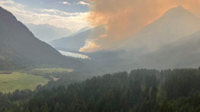
A wildfire near Pemberton, B.C., about 140 kilometres north of Vancouver,hadgrown to seven square kilometres by Wednesday afternoon, according to the B.C. Wildfire Service (BCWS).
More than 20 properties near the Birkenhead Lake wildfire are on evacuation alert, including the housing project Birkenhead Lake Estates.
The BCWS lists the fire as out of control a designation that means it is spreading,or is expected to spread, past its current perimeter.
"We have had crews and aviation resources responding to it continuously, although it has exhibited itself in very steep and challenging terrain," BCWS fire information officer Kimberly Kelly said.
The wildfire was likely caused by lightning, according to the BCWS. It'sone of about 370 wildfires burning across the province,most of which were caused by lightning, as of Friday evening.
Kelly said the fire was first spotted in August but started to grow quickly on Wednesday when winds picked up. Shesaid the area also has plenty of fuel, packed with close canopy, fallen trees and mature timber.
The fire is on steep ground, she said, which makes it difficult for crews to respond and can loosen debris and trees, which are liable to fall down slopes.
Crews have built some containment lines around it and have water sprinklers active on its east side, she said.
While the coast may see rainfall and cooler temperatures this weekend, Kelly said it's too early to tell what effect the weather will have on the fire's behaviour.
All clear status
On Friday,the Thompson-Nicola Regional District (TNRD)downgraded the evacuation order for around seven addressed properties to all clear. The majority of them are in the community of Venables Valley,an agricultural region about 70 kilometres west of Kamloops.
They are now part ofhundreds of properties that, since Aug.7, have been given the all-clearby the district.
The TNRDsays 12 addressed locations in the Venables Valleyremain evacuated due to the 281-square-kilometreShetland Creek blaze. It remains one of four wildfires of note in the province, which means it is highly visible or poses a potential threat to public safety.
Wildfire risk remains
In a report Friday, the service said it's expecting dry lightning strikes in some parts of the central and southern Interior, while cooler temperatures in some parts of southeast B.C. may dampen fire activity.
Meanwhile, the BCWS said northern B.C.continues to see higher-than-normal temperatures that will continue to heat and dry wildfire fuels over the weekend.
"We ask everyone to be mindful of activities that could spark a new wildfire, as fuels will be susceptible to new ignitions," it said.
The service has banned campfires in most of the province, except the Prince George and northwestfire centres andHaida Gwaii.
Environment Canada has issued a series of severe thunderstorm bulletins for the Fraser Canyon, Nicola, South Okanagan, South Thompson and Boundary regions.
The weather office says the storms could produce heavy rain, and there's a heightened risk of debris flows in areas scorched by recent wildfires.
Natural Resources Canada says it expects climate change to drive an increase in hot and dry weather, which makes wildfires more likely to start and increases fire behaviour.
Some researchers also expect human-caused climate change to increase lightning activity one study links each degree of atmospheric warming to a 12 per cent increase in the annual number of lightning strikes.
BlueSky Canada, a weather tracking collaboration between the B.C. and Alberta governments, shows wildfire smoke hangingover most of Canada.
Its interactive smoke forecast map shows smoke is creating particularly high concentrations of tiny particlesin the air over Manitoba and Saskatchewan.
With files from the Canadian Press


_(720p).jpg)


 OFFICIAL HD MUSIC VIDEO.jpg)
.jpg)


