Surge of water from B.C. landslide dam breach fills Fraser River
Concerns over salmon run as modelling expects water and debris from the surge to reach Hope on Tuesday
UPDATEAug. 7, 2024:B.C. landslide river surge expected to reach Lower Mainland on Wednesday
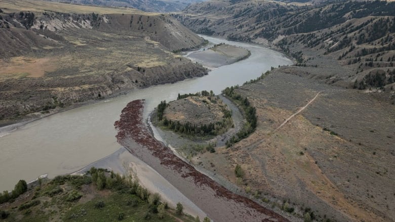
One day after water spilled over and breached the landslide blocking the Chilcotin River, officials, First Nations and residents in the B.C. Interior are assessing the damage as the backed-up flow surges down the Fraser River.
In an updateTuesday morning, the province said significant woody debris is flowing downstream along bothrivers.
At about 6:45 p.m. PT Monday, the leading edge of the water surge had reached Big Bar on the Fraser River, about 70 kilometres downstream of the Chilcotin-Fraser confluence. There, the flood reached peak flow Tuesday morning.
Connie Chapman, with B.C.'s Ministry of Water, Land and Resource Stewardship, told reporters at a news conference the released water is expected to cause river levels to rise by more than two metres near Lytton by 3:30 p.m. PT.
Modelling predicts the Fraser Rivernear Hope, around 300 kilometres downstream of the confluence, will rise by nearly a metre by about 2 p.m. Wednesday, she added.
In a live update on Tuesday, Chapmanclarifiedthat high river levels will be seen at Hope in the afternoon, but that peak river flows are not expected until around midnight on Tuesday.
"As mentioned yesterday, the risk of a worst-case scenario has drastically decreased, but we are not in the clear yet," said Bowinn Ma, minister of emergency management and climate readiness, in the Tuesday update.
She urgedpeople to stay off the Chilcotin and Fraser riverbanks.
"Now that the water is flowing past the natural dam, there is a risk of further landslides, both upstream and downstream of the dam," Ma said, adding that two emergency alerts were issued Monday, advising people in areas at risk of flooding to evacuate immediately.
"We are prepared to issue more alerts, should they be needed, as the situation evolves."

The landslide last Wednesday dammed the Chilcotin River at Farwell Canyon,which sockeye salmon must pass through on their way to spawn.
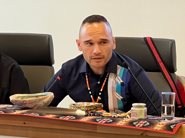
"We have some relief that the slide area has been released," Chief Joe Alphonse, chair of the Tilhqot'in National Government, said at a news conference Monday.
Evacuation orders remain in place for the banks of the Chilcotin River from near Hanceville, B.C., to where the Fraser and Chilcotinrivers meet, plus the banks of the Fraser immediately upstream and downstream of that confluence.
An evacuation order is also in place for 1.5 square kilometres near the Churn Creek Bridge.
Several districts in the area have also issued evacuation alerts along the river banks. In an evacuation alert Monday, the Thompson-Nicola Regional District recommendedthat anyone within 300 metres of the Fraser River banks prepare to evacuate.
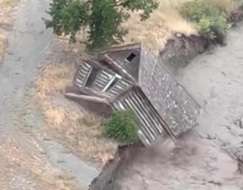
Photos from social media show the flood damaged a cabin on the Pothole Ranch inFarwell Canyon, near where the slide was first reported.
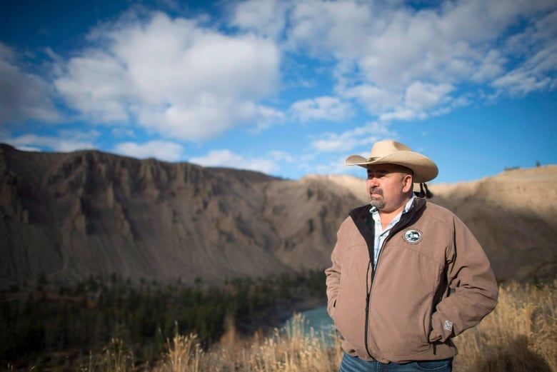
"How much energy going into that river system, and making its way to the Fraser, is pretty staggering," Williams Lake First Nation Chief Willie Sellars said.
"Much work is going to be needed when ... this river cools down to its natural flow rates."
While the extent of the damage is not yet clear, Sellars said flooding has reached historically and culturally significant places along the riverbanks, including important fishing spots.
Alphonse said a "handful" of structures, including small cabins along the Chilcotin River, were also swept into the water.

Alphonse said the province should have involved theTilhqot'innationsin its emergency response and flood management, adding that localknowledge of landslides could have improvedflood modelling.
"This is our land, we are the ones who know how to deal with this," he said.
The Ministry of Emergency Management and Climate Readiness responded in a statement,saying that staff from multiple B.C. ministries have engaged with First Nations, local governments, the Department of Fisheries and Oceans andexternal specialists on various occasions.
"First Nations partners continue to provide invaluable knowledge gained by living on and caring for this land for millennia," said the ministry, adding that First Nations chiefs and councillors have been taken on reconnaissance flights almost daily since July 31 to monitorthe landslide andculturally significant sites.
"All communities with traditional territory within the impacted area have been invited and attended the multi-way recommendation calls for orders and alerts in the area," the statement added.
"We're thankful to the [Tilhqot'in] rangers who are providing security around the evacuation order area and Farwell Canyon, visually monitoring the slide site and contributing traditional knowledge, information and advice."
The landslide was first reported last Wednesday on the Chilcotin River near Farwell Canyon, about 285 kilometres north of Vancouver. The area is also known as Nagwentled, which in the Tilhqot'in language roughly translates to "landslides across the river."
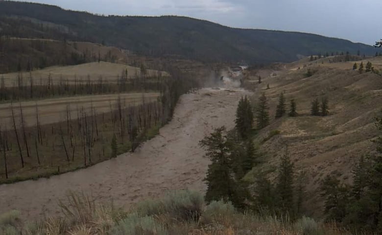
The slide created an approximately 30-metre-high dam that blocked the Chilcotin River for days. Water, debris and fallen trees built up behind the dam, creating a rising lake where the river used to flow.
On Monday morning, water and debris spilled over the dam and began to flow down the Chilcotin River. It surged over the Chilcotin River banks at rates higher than the typical levels at spring melt.
In the 24 hours before 10 a.m. PT Tuesday, according to the province, the lake that had formed behind the dam had drained by 15 metres.
Concern for salmon
First Nations have raised concerns about how the flooding will affect how salmon swim up the river, on their yearly migration to spawn.
Nathan Cullen, B.C.'s Water, Land and Resource Stewardship minister, told reporters Friday the sockeye salmon run was only days away from passing through the area.
Alphonse confirmed Tuesday that salmon head through Farwell Canyon to spawn in ChilkoLake in early August. But he said debris and silt from the flooding could greatly reduce the salmon run.
"We don't know how many are going to get through. There may be some but it's going to be very, very challenging,"he said.

Sellars said it's not yet clear what the impacton salmon will be.
"The salmon are resilient and they're smart and they're always going to find a way," he said. "Are they going to be able to find that way in a timely manner and get to those spawning grounds? I just don't know."
He said First Nations, the province and fishing authorities will need to collaborate to mitigate the impacton the salmon run.
Sellars said he's working with other First Nations in the region, and the Upper Fraser Fisheries Conservation Alliance, to bring 1,000 sockeye salmon to Williams Lake First Nation, so members who rely on the salmon run for sustenance will have food over winter.
"We're going to be able to persevere and we're going to be able to get through this and our people are going to be healthy. That does fill our hearts," he said. "But there's still a ton of work to do."
With files from Akshay Kulkarni and Bridget Stringer-Holden


_(720p).jpg)


 OFFICIAL HD MUSIC VIDEO.jpg)
.jpg)


