Evacuation alert issued for community in southeast B.C. as incoming rainfall fuels fears old dike might fail
Incoming storm could bring up to 80 millimetres of rain to the Elk Valley, warns Environment Canada
Residents of Six Mile,north of Nelson, B.C., are being asked to prepare to leave their homes as the district's Emergency Operations Centre issued an evacuation alert for the whole community.
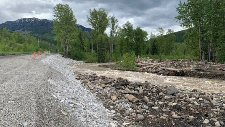
Chris Johnson,EOCdirector for theRegional District of Central Kootenay,saysa decades-oldorphaned dike near a creek by Six Mile could fall apart if water levels continue to rise, with heavy rainfall forecast for southeast B.C. on Monday and Tuesday.
"Six Mile itself has a creek on it called Duhamel Creek," Johnson told CBC News. "We are concerned with this [dike] rapidly deteriorating during high flows ... to speak frankly, the structure could fall apart at any time when we get into higher flows," Johnson told CBC News.
An orphaned dike is so named because it is not owned or maintained by anyone.
While residents of the community are not yet required to evacuate, Johnson says they should be prepared to leave at any moment.
#Evacuation Alert issued by @RDofCK for approximately 120 properties in Six Mile, Electoral Area F. For more info: https://t.co/FxgbtBWeQg #BCFloodhttps://t.co/MRV6VHqj0L
—@EmergencyInfoBC"Know where you are going.You might get evacuated while you're at work," Johnson said. "We're expecting up to 50 millimetresof rain in the next 24-48 hours. Make sure you have important documents, clothes ... some people won't necessarily be able to go back into their homes."
Johnson says the district board has been looking into replacing the six-decadeold orphaned dike.
"We are waiting for preliminary designs to be completed to determined potential costs associated with the project," he said.
Flood warnings for Elk River and Liard River
As of the morning of June 13, the B.C. River Forecast Centre had two activeflood warnings posted online: One, issued at 8:15 am for the Elk River in southeastern B.C. and the other for the Liard River around Fort Nelson in B.C.'s far northeast, issued June 11, which local officials say do not impact many residences.
A flood warning is the most serious in a three-tiered alertsystem used by the forecast centre and means flooding is expected.
A flood watch, on the other hand, means that river levels are rising and flooding may occur. The high streamflow advisory is the lowest of the three levels issued by the River Forecast Centre.
Large part of southern B.C. under flood watches as storm bears down
Many other waterways in the province are under flood watches as Environment Canada has issueda rainfall warningfor the Elk Valleyin the East Kootenay.
The forecaster stated 50-80 millimetres of rain could fall in the area by Tuesday morningand areas near Fernie are expected to receive the highest amount of rain. The rainfall could result in localized flooding, according to Environment Canada.
In addition to the flood warning for the Elk River at Fernie, theRiver Forecast Centrehas posted flood watches to rivers around Invermere, Radium, Revelstoke and as far west as the Shuswap, while maintaining flood watches for rivers from the Cariboo to the East Kootenay.
The unsettled weather has also prompted a snowfall warning for the highest elevations of Highway 3 as forecasters say 10 to 15 centimetres of snow is expected to blanket the route between Christina Lake and Creston by late Tuesday.
High streamflow advisories were also issued early Monday across the Okanagan, Boundary and Similkameen, and similar advisories remain for the Thompson region and the entire Fraser River corridor from Quesnel south to the ocean.
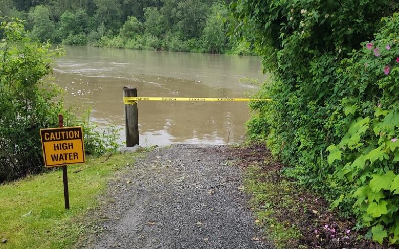
No evacuations have been ordered but alerts are still in effect for Six Mile, a small community near Duhamel Creek north of Nelson, 18 properties along the Tulameen River west of Tulameen, and for about 40 properties along the Fraser River in the eastern Fraser Valley District of Kent.
'Significant flows'
The provincial river forecast centre said rivers could rise to levels not seen in a decade, according to its current hydrologic modelling, "indicating risks for flooding" Monday and Tuesday, especially in the East Kootenays.
"Given the uncertainty in the position of the weather pattern and heaviest rainfall," the centre said in a statement, "itis possible that adjacent areas inthe West Kootenay and Upper Columbia also experience significant flows."
In response to the flood watch the centre issued Saturday for the North Thompson River, including tributaries around Barriere and Clearwater, the District of Clearwater activated its Emergency Operations Centre to Level 1.
Clearwater Mayor Merlin Blackwell says there areconcerns about the long-term forecast, which includes rain and temperatures in the low 20s and high-teens, andsnowpack levels that are unseasonably high.
"If that continues and the rain continues, that...could cause us a problem if we don't see a change in that forecast," he said.
Many other regions of B.C.'s Interior are either under a flood watch or a high streamflow advisory.
In the Fraser Valley, the Marina Park path in Fort Langley was closed Sunday due to rising water levels.
Parts of the Fraser Valley Regional District, including Hope, Boston Bar, Spences Bridge, and Yale, experiencedlandline telephone outages on Sunday, affecting 911 service. Telus reported later Sunday that all service had been restored.
NorthernB.C. concerns
Waterways in northeastern B.C. remain a concern, as a flood warning continues for the Liard River from Fort Nelson to the Yukon boundary and high streamflow advisories remain posted for other northern rivers and streams.
The centre says northern rivers that showed signs of levelling off Saturday could surge again due to weekend rains.
Earlier alerts for homes around Smithers and Terrace in northwestern B.C. were lifted over the weekend as levels of the Bulkley, Skeena and other northwest rivers subside.
With files from The Canadian Press


_(720p).jpg)


 OFFICIAL HD MUSIC VIDEO.jpg)
.jpg)


