State of emergency, flood warnings follow heavy rains on Vancouver Island
Tseshaht First Nation says Highway 4 to Tofino and Ucluelet expected to flood and be impassable Friday night
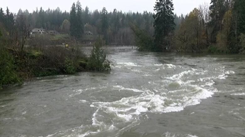
Heavy rainfall has led to a state of emergency at a First Nation near Port Alberni, B.C., and flood warnings across other parts of Vancouver Island.
The TseshahtFirst Nation declared the state of emergency at 3 p.m. PT Friday after "serious flooding" on the reserve Thursday night.
They say they have begun to sandbag homes on the reserve and residents will be evacuated to other accommodation as needed.
@Tseshaht Chief Cynthia Dick requests more volunteers for sandbagging.#PortAlberni #Nuuchahnulth #bcstorm #Indigenous pic.twitter.com/eL8YWsoam4
—@TseshahtTheTseshahtsay it is "very likely" that Highway 4 to Tofino and Ucluelet, which goes through the reserve, will be flooded and impassable Friday night.
The River Forecast Centre has issued:
- A flood warning for Central Vancouver Island, including the Sproatand Somass rivers and surrounding creeks and tributaries near Port Alberni.
- A flood watch for East Vancouver Island and the CourtenayRiver.
- A flood watch for East Vancouver Island including the Browns, Tsolum, and Oyster rivers, and surrounding creeks in the Bowser, Courtenay and Campbell River area.
- A high streamflow advisory for West Vancouver Island including Tofino Creek and North Vancouver Island including the Zeballos and Gold rivers.
More rain coming
CBC meteorologist Johanna Wagstaffe says mostof Vancouver Island saw between 120 and 200 millimetres of rain earlier this week.
There was a short break Thursday and Friday, but the rain returned Friday afternoon.
"It's definitely something to watch, especially since this is almost pineapple express atmospheric river setup," she said.
"We've already seen a number of heavy rain and rainfall warnings in place. The ground is saturated, the rivers are saturated, and now this latest surge comes overnight intoSaturday this is when you start to worry."
Wagstaffe said there will be a bit of a break in the rain on Sunday, but another storm is headed for the West Coast heading into Monday.
"I wouldn't be surprised if there are more warnings, both for the rivers and from Environment Canada, as we get intoSaturday," Wagstaffe said.
Although rain is the biggest factor in the forecast, gusty winds are expected as well. Winds are expected to approach 80 kilometres per hour.
With files from Justin McElroy


_(720p).jpg)


 OFFICIAL HD MUSIC VIDEO.jpg)
.jpg)


