Southern Manitoba flood risk down slightly, but southwest remains a concern
Risk of major flooding remains for Souris River; Assiniboine threat moderate to major
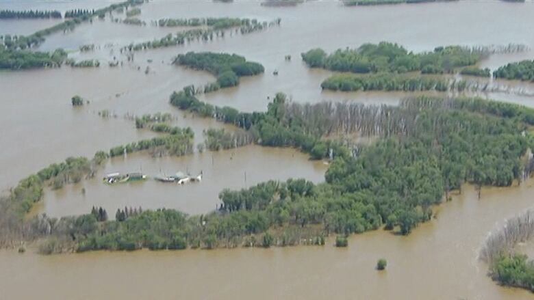
The risk of overland flooding in southern Manitoba has been downgraded by provincial flood forecasters but the southwestern corner of the province remains a major concern.
In the final flood forecast of 2017, Manitoba Hydrologic Forecast Centre director Fisaha Unduche said today there is still a risk of major flooding on the Souris River and in other areas of southwestern Manitoba, which were hit hard by a blizzard earlier this month.
The Souris flood could be almost as severe as it was in 2011if there's unfavourable weather a lot of rain or snow and a quick melt over the next month, the forecast says.
The risk of flooding on the Assiniboine River, Pembina River and Roseau River is now pegged at moderate to major, which means weather conditions over the coming weeks will dictate the need for temporary flood protection measures.
"The risk of flooding is still dependent on future weather conditions," Infrastructure MinisterBlainePedersen said at a press conference at the Manitoba Legislative Building.
The risk of flooding on the Red River is nowmoderate. Provincial officials said no major dike closingsare expected in the heavily populated Red River Valley, except for the border town of Gretna, which sits just above the Pembina River. Highway 75, the major artery running south from Winnipeg to the U.S. border,is at a very low risk of closing.
This forecast is less severe than it was a month ago.In the first forecast of the season on Feb. 27,Unduchesaid there was a major risk of flooding along the Red River, Roseau Riverand the lower portion of theAssiniboineRiver.
He identified the risk of flooding on theSourisRiver as as severe.
Those were worst-case scenarios, dependent on unfavourable weather conditions such as a lot of snow or rain and a quick melt.
All of the communities along those rivers have sufficient flood-protection measures in place to deal with the worst-case predictions, he said today.
In Winnipeg, the Red River is now expected to crest between 15 and 18 feet above normal winter ice levels at James Avenue, which constitutes a minor flood. That level isbelow that of other recent floods.
The Red River Floodway may be operated.
There is also a concern about Dauphin Lake, which is very high. Concerns about Lake Manitoba are lower, even though the province expects to divert some Assiniboine River water through the Portage Diversion.


_(720p).jpg)


 OFFICIAL HD MUSIC VIDEO.jpg)
.jpg)


