Southern Manitoba faces risk of major spring floodingalong Red River and its tributaries
Flooding risk is low for the Interlake region and northern Manitoba
As southern Manitoba remains enveloped in freezing temperatures and seemingly endless snow flurries, there's another "F" word that keeps coming to mind flooding.
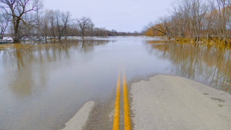
The province's Hydrologic Forecast Centre released its first flood outlook for the season on Friday and is predicting major flowsalong the Red River and its tributaries, including the Roseau, Rat and Pembina rivers.
At this time, all are expected to remain below flood protection levels inall communities along their path.
There is also a risk of moderate flooding for most other southern Manitoba basins, including the Assiniboine and Souris rivers and the Whiteshell lakes, a news release from the province says.
The risk of spring flooding is low, however, for the Interlake region and northern Manitoba regions.
Of course, the current outlook is dependent on future weather conditions,including the amount of snow still to come, the speed at which it all eventually melts, the amount of rain that follows, the release says.
In favourable weather conditions, the risk of flooding could actually be low to moderate, theHydrologic Forecast Centre report states.Levels would be similar to spring peak levels in 2013 from Emerson to the Red River Floodway inlet south of Winnipeg.
Normal weather patterns will bring a high risk of moderate to major flooding with levels near the spring peak levels observed in 2019 and 2020 from Emerson to theinlet.
Unfavourable weather would createa high risk of major flooding with levels on the Red River main stem similar to 2009 from Emerson to the inlet.
Thefloodof2009caused just under $7.5 million in damage in Winnipeg and forced hundreds of people out of their homes in southernManitoba.
In 2019, flood forecasters predicted a major deluge that turned out to be moderate, thanks to perfect weather conditions that slowed the spring melt. Even so, the flood level atEmerson wasthe seventh highest since 1903.
So far this winter, Winnipeg has received more than143 centimetres of snow with two more snow months to go. Theaverage snowfall for an entire winteris 127.6 cm, said Rob Paola, a retired Environment Canada meteorologist who runs the popularTwitteraccount @robsobs.
February alone has had more than 33cm of snow;a normal total for the month is about 15 cm.
Most Manitoba river basins have received10 to 30 millimetres more precipitation than normal for this time of year, with some areas getting as much as 50 mm more,theHydrologic Forecast Centre report says.
Some areas of the U.S. portion of the Red River basin have received up to 200 per cent of normal precipitation since Nov. 1, thereport says.
It's a drastic change from last winter, when parts of southern Manitoba received less than 20 millimetres of precipitation between November and March inone of the driest years on record.
That led to serious drought conditions across the province but has also meant the soil moisture levels were lower than normal, and that could allow the ground to absorb a greater amount of the snow melt this spring, reducing overland flooding and runoff into the rivers.
The U.S. portion of the Red and Souris river basins, however,have normal to above normal soil moistures. That could impact the amount of water getting into the rivers and flowing into Manitoba from the south,the flood report says.
Another key factoris river levels at the time of the melt. Because fall was so dry, thoselevels within Winnipeg were quite low at freeze up, so the riversdo have some room to take in water.
Similarly, most of the major lakes are below normal levels for this time of year, the report says. As a result, the risk of flooding for most lakes is low.
And then there is frost depth deeper frostcan limit the amount ofsurface water that can soak into the soil. The flood report says the current frost depth is variable across the watershedsbut is generally considered to be normal to deeper than normal throughout most of the province due to prolonged frigid winter temperatures.
James levels
If weather conditions are favourable for the rest of winter, the flood forecast predicts peak water levels will be5.2 to 5.5 metres(17 to 18feet) above normal winter icelevelat James Avenue in downtown Winnipeg.
Normal weather conditions would push that to between 5.5 to 5.8 metres (18 to 19feet),whileunfavourable weather could make it5.8 to 6 metres (19 to 20feet).
James Avenue datumis a scale used to measure the water level in Winnipeg near the Centennial Concert Hall. Zero "feet James" is defined as the normal winter ice level and two metres (6.5 feet) is the normal summer water level.
During the1997 flood of the century, thewater levels hit 24.5 feet.
Regardless of changes in the forecast, operation of the Red River Floodway is expected this spring to reduce water levels within Winnipeg, with some operation of the Portage Diversion anticipated to prevent ice jamming on the Assiniboine River, which can cause upstream flooding.
The floodway is a 47-kilometrechannel that diverts part of the Red River's flow around the east side of Winnipeg, from an inlet near St. Norbert to an outlet near Lockport.
Since the floodway was built, most floods in the city involved river levels just below six metres (20 feet) at James.
The Portage Diversionis a 29-kilometre channel that starts at an inlet near Portage la Prairie and redirects some water from the Assiniboine Rivernorth into Lake Manitoba.
The province's next flood outlook will be released late March.
Ice cutting to reduce jams
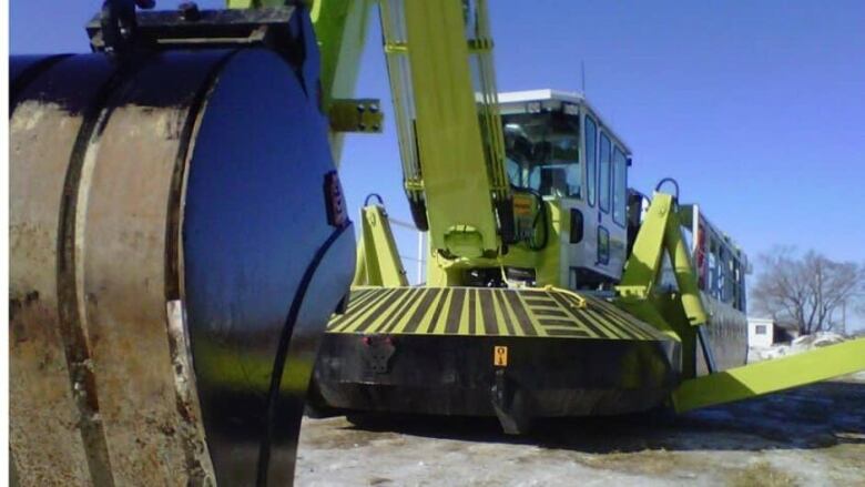
Manitoba is sending out its Amphibex icebreakers this weekend as part of itsannual effort to prevent spring ice jams and related floods.
The 20,000-kilogram machinesare used to break upice and open channels in rivers before and during the spring thaw.
When the rivers begin flowing again in warmer temperatures, they move ice chunks downstream.Ice jams form when those chunks hit a blockage of solid ice,forcing a backup of water that can spill over the banks.
The Amphibex a type offloatingbackhoe wasoriginally designed to perform river dredging using itsexcavator-like claw during the time of year when the rivers were thawed.
But the government found another way to use them and take advantage of their weight. The operator uses the claw topush the machine up, then lets it drop back down, smashing theice apart.
Remote-controlled ice-cutting units are first used to cut into the ice then the Amphibexes follow up by breaking it all up.
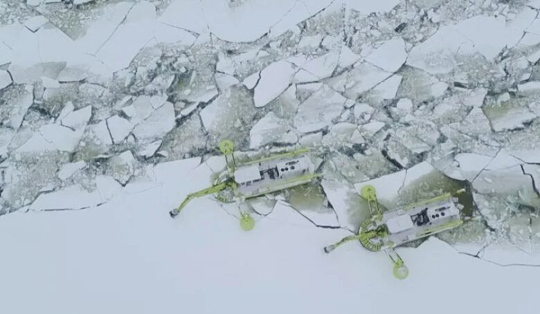
Every year, the ice-jam mitigation program works to open up a channel about100 metres wide, stretching for 28 kilometres from Selkirk to Netley Marsh.
Ice-cutting and breaking is also often completed on the Icelandic River at Riverton and at the outlet of the Portage Diversion as well.
Notices have been posted in areas where the operations will be taking place.Ice fishers will also be reminded to remove huts or other materials in the areas covered by the ice-jam mitigation program.


_(720p).jpg)


 OFFICIAL HD MUSIC VIDEO.jpg)
.jpg)


