So sorry, southern Manitoba, but there's more snow on the way
Environment Canada watching yet another Colorado Low tracking towardManitoba
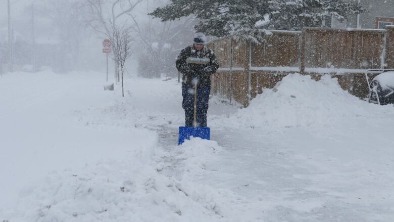
The weekend snowfall in southern Manitoba, which came on the heels of a three-day snowstorm, has ended just in time ...for more snow.
Environment Canada's forecast calls for a chance of snow on Tuesday with more certainty of it on Wednesday, but that's just the primer.
The weather agency is watching yet another Colorado Low tracking towardManitoba for this coming weekend the same type of weather system that brought heaps of snow last week
"We're not really sure whether it's going to bring snow or rain or freezing rain or all of them. At this point, we just don't know yet. It's not clear enough,"saidEnvironment CanadameteorologistDave Carlson.
"But what it does appear like is that there's going to be a lot of moisture dropped within this system. Pretty much all the forecast models are pointing to 25-40 millimetres of water equivalent, whether that's dropped as snow or as rain over a big portion of southern Manitoba.
"So, yeah, there's more moisture coming."
The system, which should impact pretty much everywhere inManitoba south of the big lakes, is expected to move in on Friday and linger through the weekend before departing to northwestern Ontario on Sunday.
A spring snowstorm, which officially reached blizzard level in some parts of western Manitoba, dumped anywhere from 13 centimetres just northwest of Winnipeg to82 cm in Onanole, just south of Riding Mountain, last week.Winnipeg received25-35 cm.
This is at my parents place in Clear Lake, MB.
Yikes. #mbstorm #blizzard pic.twitter.com/39G9eFBe8S
—@RadioClaytonThe sun showed up for a brief cameo appearance on Saturday before stepping aside on Sunday to allow for another re-topping of snow.
About 8-10 cm fell in general, thoughhigher elevations southwest likely received more, said Carlson.
"I expect that Turtle Mountain probably got more, maybe 10 to 15 centimetres, but I don't have any confirmation of that," he said.
Late spring snow is not unheard of in Manitoba. The Victoria Daylong weekend,considered theunofficialstart ofsummer and camping season, has been snowed under in the past.
It isabnormal to get so much, though, Carlson said.
"Usually we get one system that brings a decent snowfall, 15 or 20 centimetres, not one after the other after the other not like we've had this year, that's for sure."
The layer of snow has also kept the temperatures below normal. The average high for this time of year is 12 C, and the forecast a few days ago when Manitobans looked for hope to get through the snowstorm suggested it could hit 8 C on Monday.
So what happened?
"The temperature is higher up in the atmosphere [and] usually that would translate to eight degrees down here, but it [the forecast model] didn't capture that we had such a snowpack here and that's modulated it so much," Carlson said.
Instead, the high for Monday is expected to be 1 C. Same for Tuesday and same for Wednesday.
"This time of year you can get really, really wild temperature changes. So that in itself isn't too, too strange but the one thing we are looking at is that tonight, for example, in Winnipeg, we're forecasting a low of 16 C," Carlson said.
"Our record low for this date is 12 C."
With a ~1pm high of -2.4C, yesterday was #Winnipeg's coldest Apr 17th in almost 70 years, since 1953. #MBWx #YWGWx pic.twitter.com/T8ifJvUYlY
—@YWG_WeatherThe normal low for this time of year is 0.
"So, yeah, that [Monday low] is particularly cold for this time of year," Carlson said.
Temperatures look to climb a bit by the end of the week, which is why it's unpredictable at this time what type of precipitation the Colorado Low will bring.
Winnipeg typically averages 127 cm of snow over the course of a winter but has so far been hit with212 cm this winter, making it the sixthsnowiest on recordas of April 17.
If the coming moisture falls as snow, that could push the totals closer to third or even secondplace, according toretired Environment Canada meteorologist and weather historianRob Paola, who runs the popular Twitter account @robsobs.
With another 9 cm of snow yesterday, seasonal snowfall in Winnipeg now stands at 212.0 cm, 6th snowiest winter on record as of Apr 17. Additional snowfall this week will likely vault us to 3rd or 2nd place by week's end #MBstorm pic.twitter.com/VT4vj6smZr
—@robsobsThe coming snow is not somethingCindy Shaurettewants to hear about. The owner ofthe Honeycomb Bed and Breakfast in Onanole is exhausted from shovelling.
"When the groundhog came out and said that we had six more weeks of winter, it was correct only it keeps going," she said.
"It's just a long, long winter. It didn't start really until December, which was great cause we had an amazing fall but then the snow and the cold just kept coming.I'm kind of done with it.
"I'm not looking forward to what's coming this weekend."

After last week's storm,Shaurettewent to check on a guest inside a private suite with its own entrance.There was a large drift blocking the door.
"I had to get a shovel and keep shovelling until I got to her door and she was just talking to me through the window," Shaurettesaid with a laugh, but noted she was quite nearly in the same predicament.
"I couldn't get out of any of my doors except for the front, which was clear.My back door where I normally go out, it was halfway up the door," she said.
Her guest, who had just returned to Manitoba after spending most of the winter in Arizona, was content to just stay in her suite. But the storm has Shaurettefacing other cancellations from guests who were supposed to come out this week.
"They wanted to go hiking, which isn't happening here," she said.
With files from Marcy Markusa and Jill Coubrough


_(720p).jpg)


 OFFICIAL HD MUSIC VIDEO.jpg)
.jpg)


