Montreal flood-zone map for hard-hit Pierrefonds is decades out of date
Most recent map for floodplain along the Rivire des Prairies is from the 1980s

Over the past few weeks of flooding in the Montreal area, one of the hardest-hit neighbourhoods has beeninPierrefondsonthe Rivire des Prairies. CBC News has learned that the floodplain map for that area ofthe city's north shore is decades out of date.
The most recent complete map for flood zones along the Rivire des Prairies that CBC was able to obtain is from the 1980s.
It's so old that it has been archived by Quebec's Environment Ministry,intended for historical reference rather than planning purposes.
Compare this outdated map to the actual flooding onan eastern sector of Pierrefonds near Saint-Jean Boulevard:
CBC contactedthe City of Montreal to ask for an explanation.
City spokesperson Jacques-Alain Lavalle said that a new map based on 2006 data was in production.
When asked why it has taken so long to update, Lavallesaid that the maps are the responsibility of theCommunaut mtropolitaine de Montral(CMM), known in English as the Montreal Metropolitan Community.
Mayor Denis Coderrechairs the CMM.
In a news conference on Friday, Coderresaid that he's asked for the creation of a working groupto address climate change and urban planning.
2006 data not incorporated into map
A hydrology analyst with the Quebec Environment Ministry explained to CBC that while the ministryproduced new data in 2006, it appears only themaps for theMiles lesRiver and the Lake of Two Mountains were updatednot the Rivire des Prairies.
Urban planners rely on accurate floodmappingto advise cities on where to build and where not tobuild critical institutions such as hospitals and long-term care homes.

Isabelle Thomas, an urban planning professor at the UniversityofMontreal, said that when she first started to work in Quebec, she was surprised at the gap.
"If you look at what has happened in Montreal in the last two weeks, some institutions, even hospitals, had to be evacuated," she said.
If you look in Europe, you have these maps. If you look in the U.S., you have these maps.- IsabelleThomas, Urban planning professor
"Obviously, if these flood maps are from the ... '80s, how can we map adaptation?" Thomas asked, adding that climate change creates even more uncertainty.
"If you look in Europe, you have these maps. If you look in the U.S., you have these maps. Even in New Orleans."
Flood data vital to development
Developers also rely on up-to-date information from the government to make sure their waterfront structures are protected from flood risks.
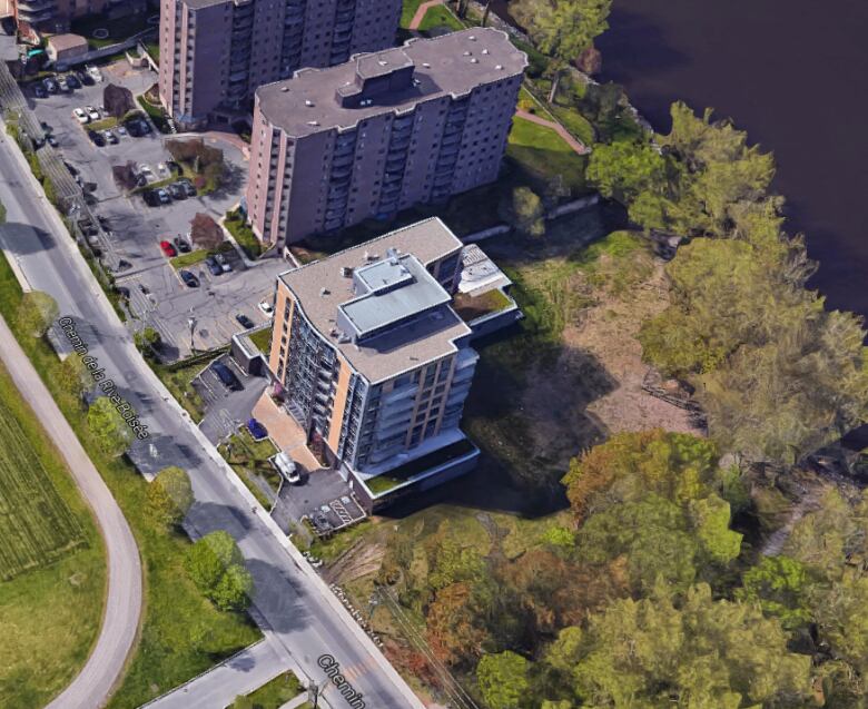
Pat Carbone was in charge of sales and promotion for the BleuMare Condominiums, which were completed in 2014 and overlook the Rivire des Prairies in Pierrefonds.
"It's vital, because if you don't have the right information, you don't build at the right level, [then] you have damage," Carbone said.
During the flooding of the past two weeks, the building has remained dry, even though another buildingjust three doors down had to beevacuated.
If you don't have the right information, you don't build at the right level, [then]you have damage.- PatCarbone, Montreal condo developer
Carbone saidthat's because his teamtook extra precaution when they built in that area.
"We built a couple feet higher than the level that the city and the Ministry of Environment had established."
Should Montreal consider a 'managed retreat?'
Jason Thistlethwaite, assistant professor at the University of Waterloo's faculty of environment, saidall levels of government need to be looking at ways to encourage developers and homeowners to move farther away from flood risk zones.
But to do that, they have to know where those vulnerable areas are.
"The government needs to come out and say, 'Look, here's where the flood risk areas are,' and that gives some leverage to municipalities to go against the developer and say, 'We think that development in this area isn't worth it.'"
- Canadian home owners in the dark about flood risks, study suggests
- 'Rebuild better:' Justin Trudeau says Canada must brace for more storm devastation
He said the U.S. actively uses a strategy known as a "managed retreat" to encourage people to move away from high-risk areas.
The idea, he explained, is that governments notify people that they have two options: Sell their home to the government at market value and move to a safer area, or remain, but accept that they'll be on their own to defend against flooding.
"The benefits of preventing a flood before it happens far exceed the costs of the damage after a flood," he said.


_(720p).jpg)


 OFFICIAL HD MUSIC VIDEO.jpg)
.jpg)


