Ottawa considers dozens more marine protected areas in Maritimes
Maps sent to CBC reveal areas under consideration that have not been made public
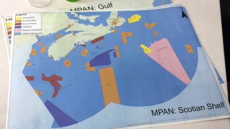
Ottawa is considering dozens more marine protected areas in Maritime waters, according to maps and other data shared by the federal government with stakeholders.
CBC News has received stakeholder planning maps based on information supplied by the Department of Fisheries and Oceans as part of its consultations.
That would represent a big increase on the Scotian Shelf, where two MPAs have been enshrined in law and three more have been declared areas of interest.
Canada is trying to set aside 10 per cent of ocean and coastal waters by 2020.
'DFOhas not consulted us on these,' says minister
Nova Scotia Fisheries and Aquaculture Minister Keith Colwell says the sites on the map are the same as those presented to the province by DFO.
He says they show about 25 per cent of the waters around Nova Scotia under potential marine protection.
"Quite frankly,DFO has not consulted us on these. We had no part in that, the selection of those sites or those potential sites," Colwelltold CBCNews.
He said the scientific information justifying the site selection hasn't been presented to the province, either.
"If we would have seen it,maybe we would accept it," said Colwell.
Political issue
The size and number of areas under some form of federal marine protection has become a political issue in Atlantic Canada, with the premiers of Nova Scotia and Newfoundland and Labrador expressing concerns about the potential impact on fishing and offshore energy development.
The fishing industry is also concerned.
"A lot of those areas completely overlap with very productive fishing areas going back to the '70s, '80s and to today," says Kris Vascotto, executive director of the Groundfish Enterprise Allocation Council, which represents larger harvesting and processing companies.
"Those interests have to be respected in the creation of marine protected areas," he says.
The mapswere created by the Mi'kmaq consultation team by overlaying data from DFO to produce what is known as a network map. It's a collection of areas currently under protection, declared an area of interest or proposed as a marine protected area.
A photo was taken at a meeting this week and sent to the CBC, not by First Nations.
DFO'on the verge' of releasing its map
"The maps are not produced by DFO, but they would come from sessions where we shared information," says Jeff MacDonald, DFO's director general of ocean management.
He said the department is "on the verge" of releasing its network map and would not discuss what is in the map obtained by CBC.
"When we are ready to release the map, you will be able to make that comparison," he said.
"It's accurate," said environmentalist Susanna Fuller when shown a copy of what was sent to CBC.
The marine science consultant has been deeply involved in developing MPAs, which she likens to land-use plans.
"It's good we finally have a plan. Are all those areas going to be marine protected areas? Likely not. Are some of them? Yes," she said.
Fuller downplays the impact on the fishery.
"We know we aren't going to have marine protected areas where a valuable fishery is going to take place. It's a given."
What the map shows
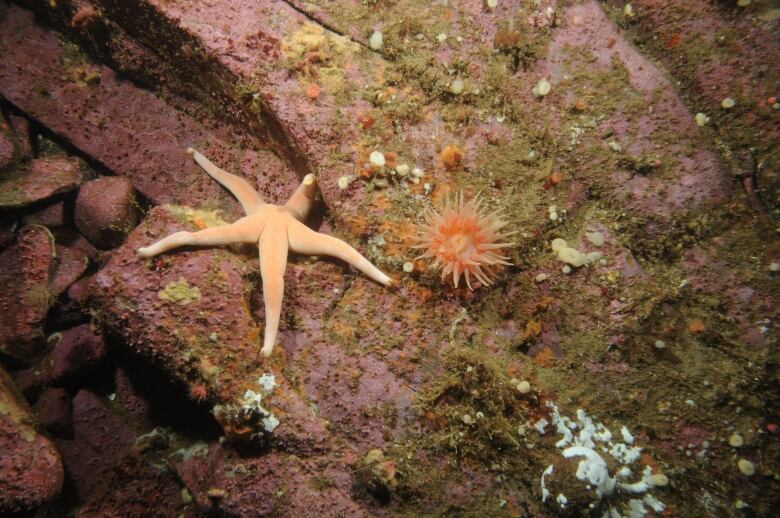
The existing MPA at St.Anns Bank off Cape Breton is 75 per cent closed to fishing and other extraction.
The proposed MPAs sent to the CBC include a small portion of the Minas Basin, but the tidal power demonstration site is outside the area. Two new large blocks in the offshore are also under consideration, as well as smaller parcels along the province's South Shore.
In the Gulf, the map includes the previously announced Cape Breton Trough, an area between Chticamp, P.E.I. and St. Georges Bay.
MacDonald says the network mapping underway is very preliminary.
"The next stage in the process is once our planning partners are comfortable, we will be releasing the MPAs for public comment so we can make a further set of adjustments to them prior to any conversation about what should be protected and how."
Fuller says even the proposed marine protected areas that make it into DFO's network map will be years away from becoming a reality.
"Our problem now is that we don't have much experience of this stuff because until 2015, we had less than one per cent protection. So now we are in the throes of a rapid protection. I think by 2030 we might be in a good position."


_(720p).jpg)


 OFFICIAL HD MUSIC VIDEO.jpg)
.jpg)


