Strong winds, heavy rain and another flash freeze set to hit Nova Scotia
Risk of outages, localized flooding and icy conditions as temperatures drop Thursday

A powerful storm tracking into the regionWednesday and Thursday will bring strong winds, another round of rain and then rapidly falling temperatures across Nova Scotia.
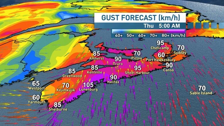
Southerly winds will ramp up throughout Wednesday and then peak Wednesday night and into Thursday morning. Power outages are certainly possible with widespread southerly winds gusting from 70 to 90 km/h. Environment and Climate Change Canada has issued wind warnings for the province.Coastal and exposed areas are likely to see gusts near, and possibly exceeding, 100 km/h. Winds will shift to northwest with gusts 50 to 60 km/h for Thursday afternoon.
Rainfall warnings are also in effect for mainland Nova Scotia. Showers on Wednesday will turn to periods of rain, at times heavy, on Wednesday evening, continuing overnight and Thursday morning.
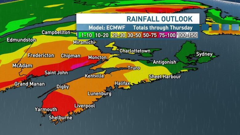
This time around, the heaviest rain is expected to fall in central and western Nova Scotia where a widespread 30 to 50 millimetres is predicted through Thursday. Localized totals in the 50 to 75millimetres range arepossible in the southwest. Totals will be lower in the east at15 to 30 millimetres.
The rain, coupled with the mild temperatures and melting snow will mean lots of water run-off and the risk of localized flooding, especially in low lying areas.
Another flashfreeze
There's a risk of another flash freeze across Nova Scotia on Thursday as temperatures are predicted to plummet.
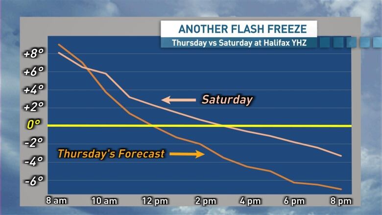
Temperatures are set to fall even more dramatically than they did a few days ago. At Halifax airport for example, temperatures last Saturday slid from near eight degrees in the morning to the freezing mark by mid-afternoon, or over about eight hours.
While it's difficult to predict which roads, sidewalks and walkways will have standing water that may turn icy, it's best to be prepared for icy conditions to develop on untreated surfaces.
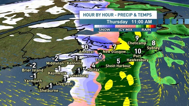
While significant snow isn't likely, a brief period of light snow and flurries is expected as temperatures drop, and will bring an increased risk of icy conditions.
Onshore flurries and a risk of snow squalls will develop in the cold northwest winds later on Thursday. Those snow squalls will linger into Friday with temperatures remaining well below the freezing mark.
Remarkably, temperatures are set to rebound on the weekend. Widespread mid to high single digits are expected both Saturday and Sunday and right into next week.


_(720p).jpg)


 OFFICIAL HD MUSIC VIDEO.jpg)
.jpg)


