Power outages likely as strong winds hit N.S., N.B., Monday night
Strongest winds will be late Monday in western N.S, southwest N.B., but will then move eastward Tuesday

When you're heading to bed Monday night, be sure you have your cellphone charging and a battery-powered alarm ready to go for Tuesday morning.That's because power outages are looking likely for parts of Nova Scotia and New Brunswick as our latest fall storm tracks through the Maritimes tonight and Tuesday.
The storm will also bring heavy rain and very mild temperatures, with double digits and even some low teens expected.
Strong winds
The strongest winds will be late Monday evening in western Nova Scotia and southwest New Brunswick, and then spread eastward across the rest of the region overnight and into Tuesday morning.
Most will see a solid eight to 12-hour period of widespread gusts measuring 80-90 km/h across Nova Scotia and southeastern New Brunswick, with coastal gusts in the 90-110 km/h range, especially in exposed areas.
Winds will then subside from west to east throughout the day on Tuesday.
Heavy rain
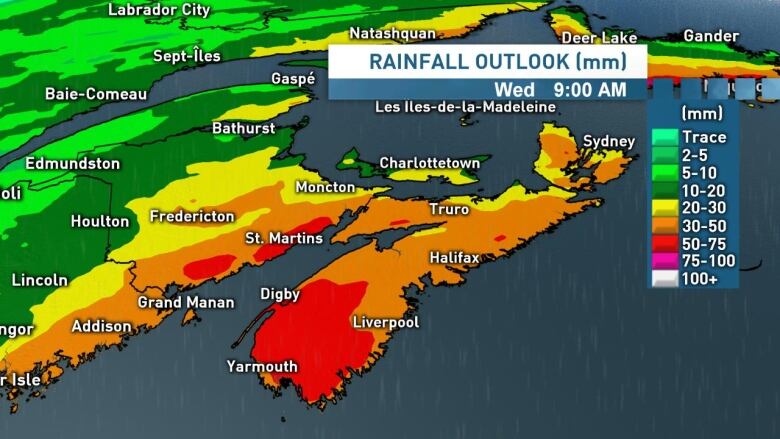
Localized flooding is certainty possible with this system, with widespread amounts of 20 to 50 millimetresof rainfall across Nova Scotia and southern New Brunswick by Wednesday morning. That said, local amounts of 50 to 75 millimetresare looking likely for the Tri-County region of Nova Scotia, as well as the Fundy coast of New Brunswick.
Icing up on Wednesday
After peaking in the double digits and even low teens across much of the region on Tuesday, we'll see temperatures plummet through Tuesday night across New Brunswick and Wednesday across Nova Scotia.
As temperatures fall, we'll see standing water beginning to freeze and some icy spots developing.
We'll also see rain beginning to mix with and then change over snow through Wednesday morning, with some accumulating snow looking possible for areas of southern New Brunswick and Nova Scotia.
In terms of possible amounts, this will be a tricky one to forecast over the next day or so, butas of now it appears a widespread swath with amounts of five to ten centimetresis possible. Stay tuned for updates.
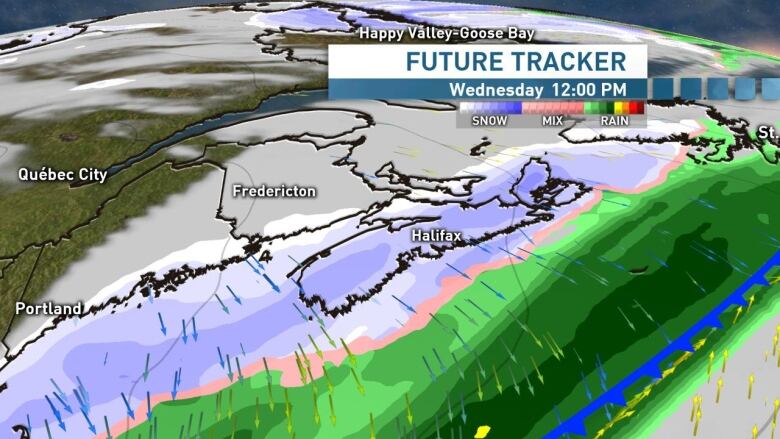
Either way, between the freeze-up and the snowfall, prepare for deteriorating road conditions throughout the day on Wednesday.
We'll be updating this storm on the live blog below, on CBC Radio and of course on CBC Televisionat 6 p.m.and 11 p.m. Monday.
Follow the live blog
Keep up to date with our live weather blog, updated every day.


_(720p).jpg)


 OFFICIAL HD MUSIC VIDEO.jpg)
.jpg)


