Hurricane Patricia strongest ever thanks to warm oceans, El Nino
When it first makes landfall ... those areas will be devastated, meteorologist says

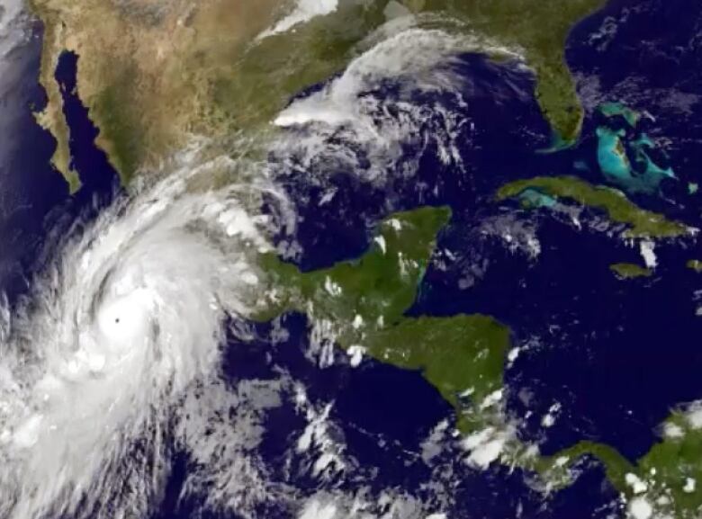
Near-record water surface temperatures off Mexico's coast have combined with a record El Nino to create the perfect storm, turning Patricia into the strongest hurricane on record in less than a day.
Hurricanes are fuelled by water vapour as it rises off the ocean's surface; the hotter the surface gets, the stronger the storm it creates.
- Hurricane Patricia, headed for Mexico, called strongest in history
- Canada warns against travel to Mexico as Hurricane Patricia approaches
- Hurricane Juan caused some long-term damage to Halifax trees
- Hurricane Patricia prompts Mexico travel warning, cancelled flights out of Calgary
In Patricia's case, the sea surface temperatures along Mexico's Pacific coastline have hovered around 30 C for the past week, one degree higher than anything recorded there in 34 years, CBC meteorologist Johanna Wagstaffe said Friday afternoon.
Once the ocean's surface reaches about 23 C, the water can start evaporating and create powerful thunderstorms as it rises, Wagstaffe said.
Monster #hurricane hits #mexico. @JWagstaffe has the latest on #HurricanePatricia making landfall #cbcnn https://t.co/2vPAfceMdX
—@PatMorrell_CBC"Hurricanes act like heat engines [and] water vapour is the fuel. The warmer that fuel is, the faster that engine can churn."
But as that vapour moves from the warmth of the seait gets colder and, eventually, it condenses and turns back into a liquid.
"That process releases latent heat," Wagstaffe said. "And that released heat then warms the surrounding air, which fuels more thunderstorms and the process starts all over again."
That helped blow up Patricia between Wednesday and Thursday night, with the hurricane registering winds of 324 km/h rising nearly 190 km/h in a day.
While forecasters had expected the storm to "intensify somewhat," a meteorologist with the Canadian Hurricane Centre said the "perfect conditions" of warm, deep water and one of the strongest El Ninos the warm currents in the Pacific suddenly turned Patricia into a Category 5 storm.
To meet that standard, a hurricane must register winds higher than 252 km/h, Jean-Marc Couturier said.
Second-strongest tropical storm
To put that in perspective, Hurricane Juan which shut down Halifax for more than a week in 2003 only briefly hit the Category 3 designation on the Saffir-Simpson Hurricane Wind Scale, Couturier said. When Juan made landfall, it was downgraded to Category 2.
Patricia may be the strongest hurricane ever recorded, but Couturier said it's actually the second-strongest tropical storm ever recorded. A typhoon, which is the same thing as a hurricane but happens in the western Pacific or Indian oceans, registered wind speeds of 333 km/h in 1955, he said.
Couturier said Category 5 storms like Patricia usually only occur every few years.
Sometimes, a hurricane of that magnitude will grow so large that two eyes form in the hurricane. As they compete with one another, the hurricane briefly loses strength.
Flooding, mudslides in northern Mexico
"An outer band of thunderstorms begins to form a ring around the eye, eventually choking out the inner eye and re-strengthening as the new eye forms," Wagstaffe said. "There is some weakening during this process, which can help if it happens just before a storm makes landfall."
But Patricia is expected to hit land as a Category 5 storm. Only then will it start to weaken, Couturier says.
"When it first makes landfall, in the vicinity of the eye, those areas will be devastated," he said. "But as quickly as it came up intensity wise, it will likely go down once it hits the mountains of northern Mexico."
The storm will bring heavy rains to that region and is expected to cause flooding and mudslides.


_(720p).jpg)


 OFFICIAL HD MUSIC VIDEO.jpg)
.jpg)


